New Map Shows The Traffic Violence Toll Of Hochul’s Congestion Pricing Cowardice
Gridlock Gov. Kathy Hochul decision to pause congestion pricing will allow carnage to continue to spread on Manhattan streets, as drivers kill and maim pedestrians and cyclists throughout the would-be tolling zone.
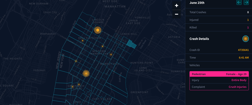
A new interactive map of Manhattan south of 60th Street — where congestion pricing tolls were supposed to launch on Sunday — tracks daily car crashes to highlight the way streets in the Central Business District remain unsafe without the 17 percent drop in traffic that congestion pricing was supposed to bring.
The map, made by Bay Area transportation activists from Transpo Maps, is a rolling counter of car crashes and the resulting injuries and fatalities in lower Manhattan in 2024. In the same way Streetsblog is tracking the revenue gains and reductions in pollution and congestion that could have been, the crash map hones in on what is happening — avoidable car crashes.
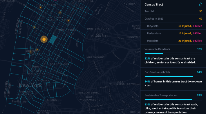
Transpo Maps’ data is further broken down by Census tract, and includes crash and injury numbers from 2023, as well as statistics about the number of car-free households and children, elderly and disabled residents in each tract. The crash data comes from the city’s traffic crash data available publicly online.
The cartographers behind the interactive map wanted to draw attention to the people directly harmed by the Hochul’s congestion pricing cowardice, they said.
“The project is really trying to highlight, here’s the people who live in the congestion zone, here are the demographics, like the percentage of people that don’t drive or that don’t own cars, that are vulnerable,” said Transpo Maps founder Stephen Braitsch.
The map demonstrated how people in lower Manhattan face plenty of chaos on the street. On average, there’s a crash every hour, every day in lower Manhattan. That traffic violence has injured 1,320 people and killed eight people since the start of the year.
The people forced to live with that state of affairs also happen to be a population particularly vulnerable to traffic violence.
“There’s a lot of vulnerable folks in lower Manhattan, about a quarter of a million children, seniors and disabled people,” said Braitach. “It’s really unfair to have those folks be under constant siege by all this unnecessary vehicle traffic.”
The city as a whole has been dealing with a pedestrian injury and death crisis all year. Before June was even up, 55 pedestrians were injured and just over 4,000 pedestrians were injured across the city, increases of 22 percent and 3.6 percent compared to last year. And now New York is down a tool to make a dent in those numbers in part of the city.
The federal government expected congestion pricing to lead to a 17-percent reduction in the number of vehicles driving in lower Manhattan. In London, the policy was credited with reducing crashes by 40 percent, something New York City won’t get to experience thanks to Hochul walking away from the policy in June.
Braitach said that he hopes the map can communicate the way that car crashes have become a baked-in part of life in the city — and noted that just as he was getting ready to publish the map, a recent pedestrian death in Hells Kitchen came through the city’s open data portal.
“That was really sad. Just as I was putting the finishing touches on the project, and pulled the latest data, to see there was a young woman that was killed,” he said.
“There’s an emotional component to this, that I think is being downplayed by the governor, which is just the impact on the people who are affected by traffic violence, because it’s just so sadly, prolific.”

Read More:

Streetsblog has migrated to a new comment system. New commenters can register directly in the comments section of any article. Returning commenters: your previous comments and display name have been preserved, but you'll need to reclaim your account by clicking "Forgot your password?" on the sign-in form, entering your email, and following the verification link to set a new password — this is required because passwords could not be carried over during the migration. For questions, contact tips@streetsblog.org.