DOT Canal Street Plan Adds Pedestrian Space, Bike Route, But Next Mayor Must Think Bigger
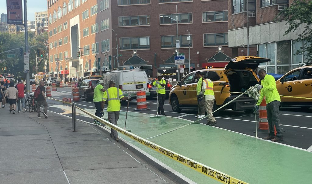
Canal Street will get much-needed wider sidewalks and a new bike connections — albeit adjacent — next year, according to a preliminary Department of Transportation proposal obtained by Streetsblog.
DOT’s plans for the stretch between the Manhattan Bridge and the Hudson River will widen pedestrian areas with so-called “Super Sidewalks” along the busiest parts of the corridor east of Broadway, and officials plan to roll out a new westbound bike lane to join the existing eastbound lane on Grand Street, according to the plans.
Transportation officials showed early details of the redesign to local stakeholders last month, and the changes are set to go live next July or August. DOT began its latest long-stalled plans on Canal Street with a study of possible pedestrian and cycling upgrades two years ago, as Streetsblog revealed at the time.
The changes are crucial and will up to the next mayor to execute — and advocates are already calling on the next city leader to think bigger now that congestion pricing has cut car traffic in the area substantially.
“This plan is a great step in the right direction, but we need more to prevent cut-through traffic on Canal Street. The next mayor should build on this change and extend the sidewalk with concrete, not just paint,” said Ben Furnas, executive director of Transportation Alternatives.
The city should also do more to pedestrianize streets around Canal, added Jon Orcutt, a former DOT official under the Bloomberg and de Blasio administrations, who now is the policy and advocacy director at Bike New York.
“We need to do something with [congestion pricing],” Orcutt told Streetsblog. “What would meet the moment would be matching it with a bunch of other stuff. We could do pedestrian streets in so much of Manhattan.”
‘Super sidewalks,’ closed slip lane and bike lanes
DOT’s plan includes “super sidewalks,” painted expansions of the footpath that also shorten crossings, on Canal between Broadway and Elizabeth Street – however not touching the block between Elizabeth and the Bowery. Why? It’s unclear from the document, but it does happen to be the block where cops from the nearby Fifth Precinct park illegally.
The agency plans to close the last block of eastbound Walker Street, between Baxter and Mulberry Streets, expanding the triangle with the Chinatown information kiosk and cutting off a side street that spews traffic like a sewer from the Holland Tunnel.
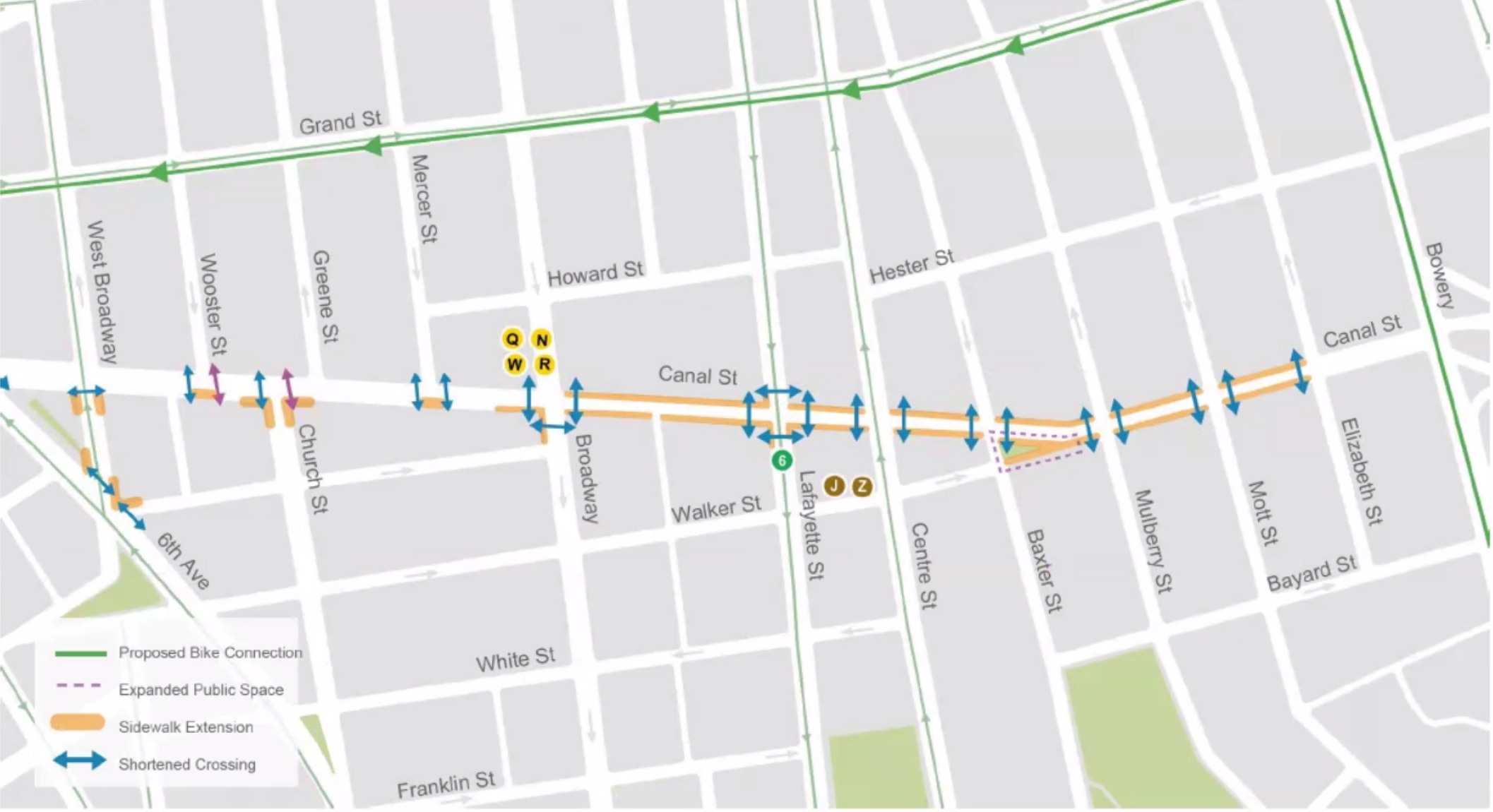
A much-needed two-way bike corridor will finally be completed. It will allow cyclists who use the Manhattan Bridge to connect via the Bowery to Grand Street – which currently has an east-bound-only cycle path – and back to Canal, between Sixth Avenue and Hudson Street then onto Watts Street to the river.
DOT will remove an eastbound lane on the furthest western stretch of Canal to make room for the new path.
The change stitches together north-south bike paths on Sixth Avenue, Hudson Street and Varick Street that currently contend with heavy car and truck traffic near the Holland Tunnel, and provide fairly direct way to head east and west too – though largely not on Canal Street itself, a concession, apparently to the continued existence of Canal as a conduit rather than a neighborhood street between the Manhattan Bridge and the Holland Tunnel.
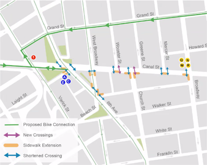
The agency will relocate parking and loading from Canal and Grand streets to side streets.
The agency will also add new street crossings and shorten existing ones along the whole corridor, including with another sidewalk extension between Greenwich and Washington streets, the plans show.
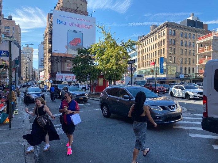
Many of the western sections of Canal Street, especially between Broadway and West Broadway, lack crossings at all corners, making for long blocks that shouldn’t exist in the city, Orcutt said.
“It’s insane that we had these sort of LA-style one leg of the intersection is safe to cross,” he said.
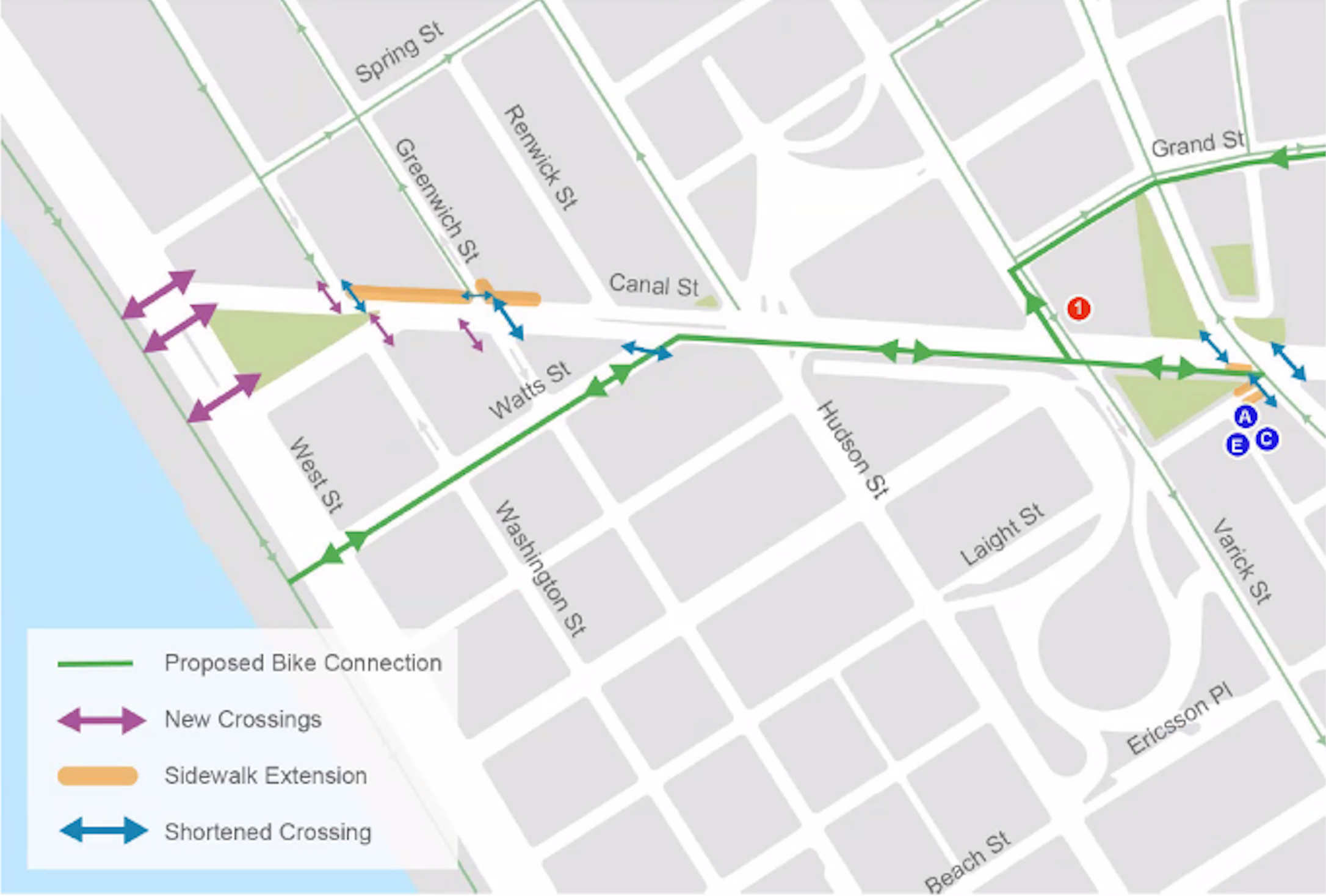
The changes will also provide a safer way for people to walk and bike to the river, as well as small Canal Park by the West Side Highway.
The agency is also looking at “opportunities” to redo Church Street south of Canal to Franklin Street, which becomes an underused offshoot because most cars head north when it forks off into Sixth Avenue.
“Maybe that’s a linear park or something,” Orcutt suggested.
There are many short streets in Tribeca and Chinatown that only go a few blocks that would be prime locations for pedestrianizations. Orcutt cited as a model the pedestrianized block of E. 25th Street between Third and Lexington avenues outside Baruch College.
Council Member Chris Marte (D-Chinatown) recently revived a decades-old push to pedestrianize much of the Financial District further downtown.
Long overdue
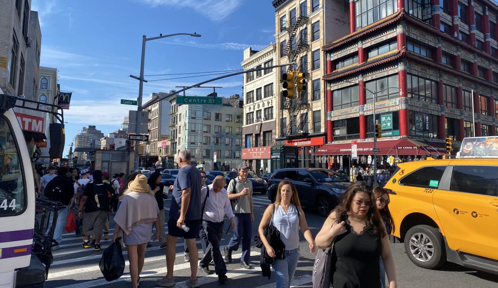
Lower Manhattanites have for decades been clamoring for more space and street safety on the deadly six-lane truck route that used to be an actual canal before the city filled it in some 200 years ago.
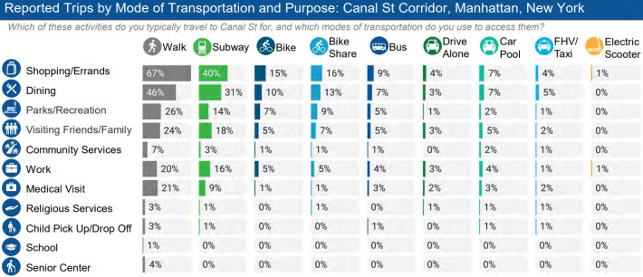
Nearly two-thirds of people in the area travel foot, but cars hog a whopping 90 percent of the street space. For virtually all purposes, people travel to Canal on foot, transit, or bike, according to a DOT survey from 2022.
Just 4 percent of shoppers, and 3 percent of restaurant-goers or people visiting use a car to get to the area, the agency found at the time
That disparity has likely only grown since congestion pricing took effect this year, with the charge discouraging the longtime practice “toll shopping” by drivers taking the street to cross the East River via the formerly-free the Manhattan Bridge.
The Holland Tunnel has seen the biggest reduction in traffic delays of all river crossings in the congestion zone, with 36 percent faster crossings over last year, according to recent data released by Gov. Hochul on Tuesday. Manhattan Bridge crossings fell by nearly one-fifth following the charge taking effect, an analysis by Streetsblog recently found.
But the Mayor Adams administration has left Canal Street virtually unchanged for years, part of his larger lack of vision to seize on the “space dividend” that the nation’s first-of-its-kind toll unlocked.
“It’s a huge historic opportunity that Adams is totally flat-footed about,” Orcutt said.
On Canal Street, the wide open lanes allowed a driver to allegedly speed unimpeded off the Manhattan Bridge exit at more than 100 miles per hour and kill two people in July. Another motorist crashed into a food truck, injuring two, at the same location within 24 hours.
That horrific wreck spurred calls by experts to stem the barrage of traffic by closing the span’s redundant lower-level lanes to private car traffic and repurpose the excess space as bus and bike lanes.
DOT has installed jersey barriers and sand barrels in a buffer near the crash site, lowered the speed limit on the bridge from 35 miles per hour to 20, and narrowed the existing lanes on the lower roadway, officials recently told the area’s community boards.
The city should move fast on the changes, given that over the Hudson River in New Jersey, leaders plan to widen a New Jersey Turnpike extension that feeds into the Holland Tunnel, threatening to funnel hundreds more cars per hour into the Big Apple.
DOT will finalize the proposal and present them to the local community boards over the coming months, and plans to install it in July or August of 2026.
A DOT spokesperson referred a request for comment to the mayor’s office. A City Hall rep said that it would be “premature” to discuss specifics of the plan, which are still “in formation” until later this year or early 2026.
“The Adams administration is dedicated to ensuring every New Yorker can enjoy safe streets, and is working to make Canal Street’s future more than a high-crash, highway-like corridor that splits Lower Manhattan in two,” said William Fowler in a statement. “We are working quickly to put forward a new street design that will protect everyone who shares this street, improve traffic flow, and address congestion on Canal Street’s sidewalks, as we continue to ensure the community has input in this process.”

Read More:
Streetsblog has migrated to a new comment system. New commenters can register directly in the comments section of any article. Returning commenters: your previous comments and display name have been preserved, but you'll need to reclaim your account by clicking "Forgot your password?" on the sign-in form, entering your email, and following the verification link to set a new password — this is required because passwords could not be carried over during the migration. For questions, contact tips@streetsblog.org.