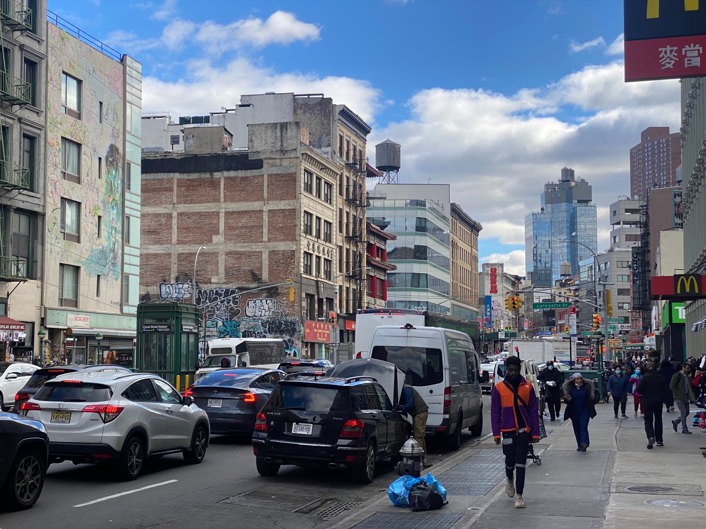
It's time to give back some flow to Canal Street.
The city will launch a long-awaited study of the sclerotic Lower Manhattan artery this spring, looking at how to fix the chronically congested car sewer and make it safer for pedestrians and cyclists, Streetsblog has learned.
The eight-month analysis will mark yet another study of the corridor that experts and advocates have investigated and proposed solutions for more than two decades — and the area's council member urged the Adams administration to actually get stuff done this time rather than just write up one more dust-gathering report.
"I’m glad that they’re doing this study, but this can’t be the end as it has been in the past," Christopher Marte told Streetsblog. "We’ve had a lot of other studies that led to really no action or limited action to improving Canal Street, so hopefully this study produces something."
The Department of Transportation study will look at "multimodal improvements to create a safer and more enjoyable street for people to walk, bike, and access public transportation facilities," and analyze how such changes would impact car traffic. The study will be conducted from April through November, according to the City Record.
A DOT contractor will collect data and analyze traffic and parking as part of the report, according to an agency spokesperson.
"Running through several iconic Manhattan neighborhoods, Canal Street presents an exciting opportunity for public space and safety improvements," said Vin Barone in a statement.
Marte hoped the city will widen the insufficient sidewalks and install a bike lane, which would add a much-needed crosstown connection between the East River bridges and the Hudson River Greenway.
The pol suggested converting the road's middle portion into an island similar to Allen Street or Houston Street, with plantings and bike lanes either in the median or along the curb.
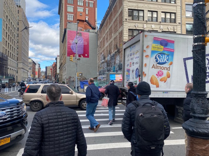
The corridor between the Manhattan Bridge and the Holland Tunnel is a through truck route and is routinely plagued by gridlock and rampant illegal and double parking.
A whopping 15 travel lanes from Canal and adjacent streets converge to just two lanes in the New Jersey-bound tunnel, causing such bad congestion in the area that the MTA has had to regularly truncate one of its local buses that couldn't complete its route during rush hours.
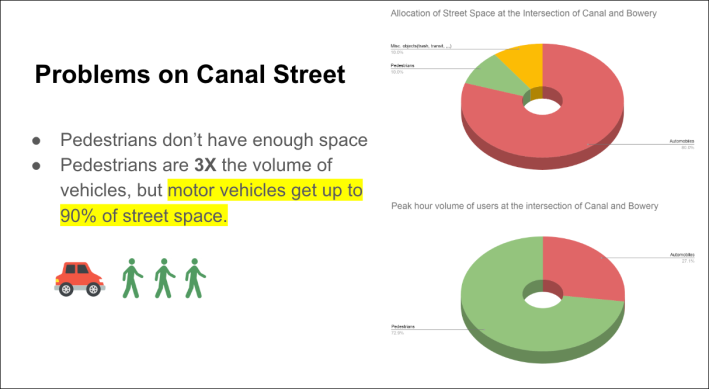
Pedestrians make up 64 percent of the streets users, but get only about 40 percent of the streetscape on paths between 12-20 feet wide, according to a DOT presentation in March.
Advocates with Transportation Alternatives, who have for years campaigned for a better Canal Street, put the space allocations for pedestrians as low as 10 percent at the intersection of Bowery, despite there being three times as many people on foot as in cars.
Thirteen subway lines stop on Canal, connecting to busy shopping and restaurant districts in Chinatown and Tribeca, but there are no bike lanes in a part of Manhattan lacking any protected paths from from river to river.
Former Mayor Bill de Blasio promised a "comprehensive" study of Canal (and another one for Broadway) as part of the 2021 SoHo-NoHo rezoning, focusing on the roughly one-mile stretch between West Street and the Bowery. DOT in its presentation last spring planned to draft a design in 2023 and release it in 2024.
Experts with the New York Metropolitan Transportation Council, a regional planning body, already studied the corridor for nearly a decade from 2002-2010, and the resulting Canal Area Transportation Study, or CATS, recommended the city expand space for pedestrians, ban left turns, and set up smarter parking regulation.
DOT announced some curb extensions and bus diversions along two blocks of Canal on the West Side last summer, following another agency study of the area including the neighborhoods to the north a year before.
But beyond the agency has made few changes of the streets layout since the big NYMTC study came out in 2011. Since then, there have been a whopping 5,745 reported crashes on Canal Street killing one cyclist, seven pedestrians and one motorist and injuring 1,029 more — or about one injury every four days on a very short stretch of one roadway.
Transportation Alternatives in 2018 launched a campaign to fix Canal, dubbing it Manhattan's "Boulevard of Death," and the advocates along with Community Board 1 and transportation experts in the following years urged the city to just redesign the street without more study.
"If they’re actually going to implement it that would be great, but if it’s just another study then why are they waisting time and money," said Annie Weinstock, the director of programs of People Oriented Cities, who penned a 2021 op-ed in these pages about the need for immediate fixes.
Weinstock raised concerns that DOT would focus too heavily on how changes to the streetscape will affect drivers and water down any proposed redesigns.
"Canal has always had traffic, so what is the goal of a traffic study," she said. “The point is that if you restrict car lanes you will be benefitting all of the other users. What is a traffic study going to do for us in those terms."
Taking a fresh look could be helpful given changes in recent years like the influx of ride-hail services Uber and Lyft, said Wellington Chen, the executive director of the Chinatown Partnership, a business improvement district.
"There are new conditions which requires us to take a pulse," Chen said. "Just because you took the temperature from 10 years ago doesn’t mean that the current temperature is still correct."
Traffic patterns are likely to change again when the Metropolitan Transportation Authority starts tolling drivers heading over the Manhattan Bridge into the central business district as part of congestion pricing, slated to kick in next year, and if officials on the other side of the Hudson River spend nearly $11 billion to widen the New Jersey Turnpike leading up to the Holland Tunnel.
