City to Close Bus-Clogged Lane on the Manhattan Bridge
It’s a start, but it’s not “envy-of-the-world” stuff.
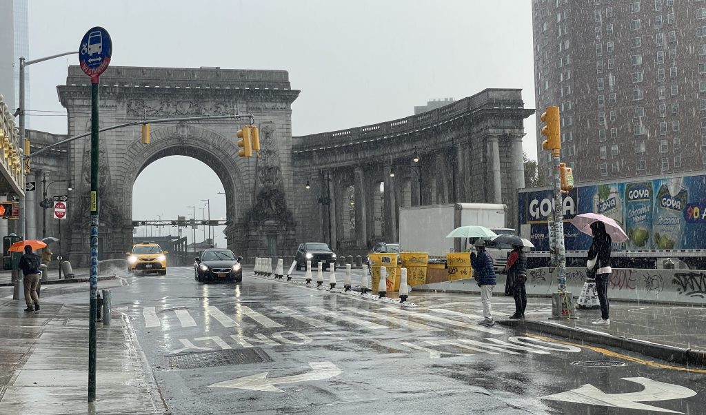
The city will close one of the Manhattan Bridge’s exit lanes to traffic in the coming months after a spate of high-speed crashes at the span, Department of Transportation officials revealed on Tuesday. But buses routinely clog that particular lane, potentially limiting the closure’s ultimate impact.
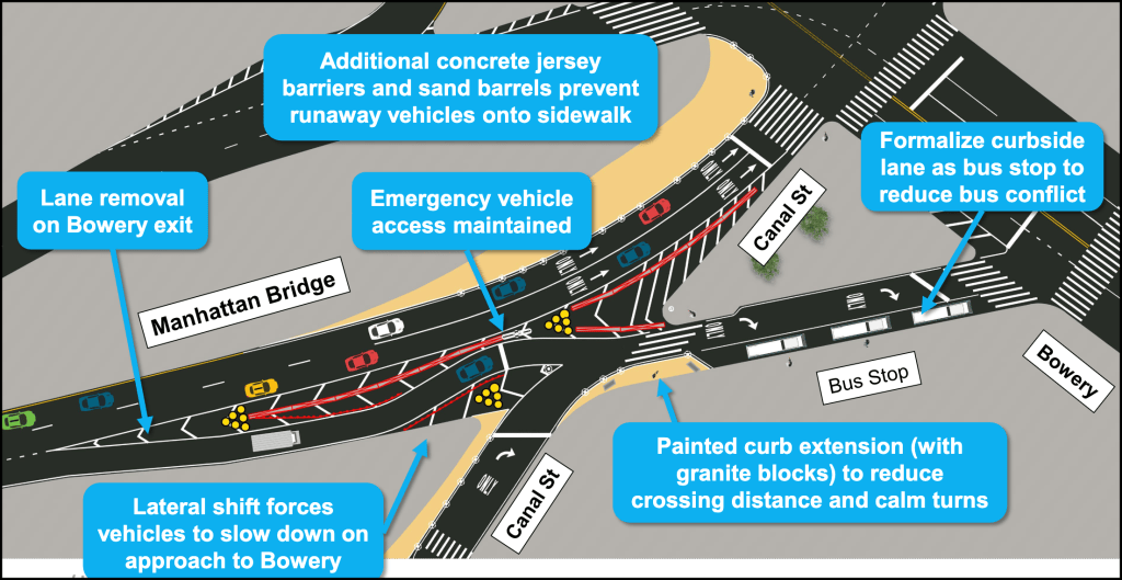
DOT plans to turn one of two lanes that connect the bridge to the Bowery into a bus stop, along with new markings, more jersey barriers and painted curb extensions to discourage drivers from barreling downhill off the bridge into the densely-populated streets of Chinatown, officials revealed in a presentation to Community Board 3’s Transportation committee.
The plan is a start, transportation experts said, but they urged the Mamdani administration to be bolder and launch a larger-scale overhaul of the 1909 span’s highway-like approach.
“It would be nice to think bigger about the Manhattan Bridge and not just make small changes around the edges — and maybe we can still get there,” said Annie Weinstock, the director of programs at the group People-Oriented Cities. “It seems like they’re kinda formalizing what’s already happening.”
DOT plans to implement the changes this fall or winter, according to the agency’s presentation, in response to locals demanding an intervention after motorists killed several people within feet from each other at the bridge’s exits over the last two years.
The right-most of the two lanes connecting the bridge to the Bowery will become a bus stop. Intercity buses routinely park up that lane already. The city plans to add so-called “lateral shift” designs to the off-ramp — basically making drivers swerve over and back — which discourages the speeding that happens on a straight shot.
The agency also plans to add more jersey barriers and paint curb extensions to improve safety at a corner with heavy foot traffic.
Two months ago, a trucker coming off the bridge at 100 miles per hour with an overweight load and malfunctioning brakes mowed down 77-year-old Ting Jun Ye. A year prior, a motorist on an alleged drunken joyride sped off the span as well, mounted a traffic island and killed cyclist Kevin Cruikshank and pedestrian May Kwok at the foot of the bridge. Another driver crashed into a food truck less than 24 hours later, injuring its operator as well as a passenger.
Along just 14 blocks of Canal Street, between the Manhattan Bridge and the Holland Tunnel entrance, the city has recorded 806 reported crashes that injured 340 people in the last five years — about six per month.
DOT installed signs on the bridge to lower the speed limit from 35 miles-per-hour to 20 miles-per-hour and added jersey barriers at the triangle where Cruikshank and Kwok were killed after the crash. But experts and victims’ friends and families have for a year urged the city to more radically transform the Manhattan Bridge to prevent the high-speed carnage from happening in the first place.
The agency has also been working on redesigning Canal Street for the past three years, reviving efforts dating back to 2002. But after pushback from parking and driving-obsessed opponents in Chinatown, officials slow-walked work on the more dangerous eastern end by postponing it until next year.
The agency’s plans for the bridge so far miss the mark for a bigger proposal to reclaim space at the entrance around its City Beautiful colonnaded arch. That’s especially the case now that the state’s congestion toll has cut car trips into the central business district, said Michael King, a former Department of Transportation director of traffic calming, who now runs the consulting firm Traffic Calmer.
“Now that we have congestion pricing, at some point the city’s gonna have to pull off the bandaid and make it a public space,” King said. “What are your priorities and what are your values. Are you going to have a real civic space… or does it have to be a highway on-ramp?”
“These little things are good and appreciated, but we can always do more and we always need to rethink the larger picture,” he added.
Weinstock and King have both studied the bridge extensively and in 2021 crafted a plan to repurpose the three-lane lower deck of the Manhattan Bridge entirely, replacing the space with bus and bike lanes.
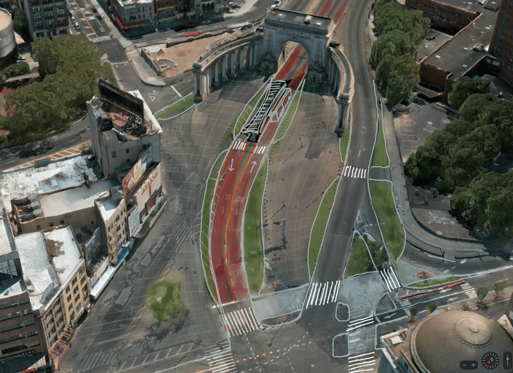
The bridge features five lanes that feed into its namesake borough, but only two Brooklyn-bound lanes. The city chose to keep that design even after congestion pricing cut bridge trips by 20 percent.
The bridge and Canal Street are through-truck routes, and Bowery is a local truck route. Ninety percent of the streetscape at their intersection is devoted to cars. Nevertheless, pedestrians still outnumber motorists by nearly three-to-one there, and the city should seize opportunities to reduce big-rig traffic through these kinds of dense urban areas, according to King.
“If you accept that everything has to be driven through Manhattan in a giant truck, then yes? Ok, you have to have truck routes,” he said. “Maybe you don’t need trucks here. Can you really only get your stuff on a truck from the Holland Tunnel to the bridge?”
DOT spokesperson Mona Bruno said there had been “too many tragedies involving drivers treating this bridge exit as a speed ramp into residential Chinatown streets that are filled with pedestrians and cyclists.”
“We are moving quickly with a redesign start this year to naturally reduce instances of speeding among vehicles approaching Bowery and Canal Street, shorten crossing distances, and better protect pedestrians on sidewalks,” Bruno added.