City Says Safety is ‘Priority’ On Coney Island Avenue — But Roadway Is Still Filled with Cars
The city named Coney Island Avenue a safety “priority” in 2015. The roadway is as dangerous now as then.
Local political leaders have demanded “urgent action” to make Coney Island Avenue safer after an especially brutal car crash killed cyclist Jose Alzorriz on the already-blood-soaked roadway last month. But residents of central Brooklyn can’t help feeling a little whiplash over the new demands for sanity along a four-lane speedway that remains nearly completely given over to cars.
The Department of Transportation named the entire 5.5-mile stretch of Coney Island Avenue, which runs between Park Circle in Windsor Terrace and the Riegelmann Boardwalk in Brighton Beach, a “priority corridor” in its 2015 pedestrian-safety action plan. At the time, the agency described Coney Island Avenue as a location “where pedestrian deaths and severe injuries are most concentrated.”
They still are.
So what did DOT do?
Roadways get on the DOT radar screen when they have a high number of pedestrians killed or severely injured — which the department calls the “KSI” rate. In the 2015 “action plan,” the agency said it would target the 49 corridors that account for half of the borough’s total KSI. Coney Island Avenue was one of them.
Getting named a “priority corridor” suggests that massive resources are brought to bear on a given roadway, or that the city had decided to undertake a complete redesign, or even that the DOT and its Vision Zero partners in the NYPD and other agencies would design a comprehensive strategy to make the roadway safer.
The reality is quite different.
Streetsblog asked the DOT for a full list of all the design changes undertaken by the departrment since Coney Island Avenue was named a “priority corridor.” Here is the full list provided by DOT:
- 2015: three refuge islands were installed at Roder Avenue, Avenue N, and Avenue O.
- 2016: the intersection of Guider Avenue was redesigned to include concrete curb extensions and concrete median tip extensions.
- 2017: a new signal was installed at the Hinckley Avenue intersection after PS 889 opened.
- 2017: the Brighton Beach Avenue intersection got new markings and signal-timing upgrades, and right-turn traffic calming.
- 2018: Quentin Road was converted to one-way operation to improve safety and bus operations. A painted curb extension and a widened crosswalk was also part of the project.
- 2019: the intersection of Cortelyou Road got a concrete pedestrian refuge island, a new crosswalk and new signal timing.
So out of Coney Island Avenue’s 64 intersections, DOT has altered eight. Eight.
Clearly, it isn’t enough: DOT’s own data shows that pedestrian KSI actually went up, from 7.7 in the period from 2009 to 2013, to 8.4 in a the slightly overlapping 2012 to 2016 period.
The injury rate for pedestrians rose 9 percent … along a pedestrian safety priority corridor.
The raw numbers on Coney Island Avenue and its surrounding streets also tell a story of stasis at best. Between 2013 and 2015, there were 2,233 reported crashes that injured 39 cyclists, 199 pedestrians and 317 motorists according to Crashmapper. From 2016 to 2018, there were 2,553 reported crashes that injured 76 cyclists, 197 pedestrians and 413 motorists in the same area, all of which occurred after the city declared the street a priority.
More crashes, more injuries.
It’s no wonder that earlier this month, Council Members Brad Lander and Mathieu Eugene, Assembly Member Robert Carroll and State Senator Andrew Gounardes wrote to DOT Commissioner Polly Trottenberg, “We have not yet seen meaningful action on the corridor” — a comment that can only be viewed as open contempt for DOT’s efforts on Coney Island Avenue since the 2015 “priority” classification.
What’s the issue?
A bike trip down the street from Park Circle to Avenue P shows exactly why the pedestrian KSI hasn’t gone down, despite DOT’s tweaks.
After Alzorriz was killed, Transportation Alternatives called Coney Island Avenue “a hostile environment, especially for those not in a vehicle.” The street is more than its collection of body shops, gas stations and car washes; there are multiple schools, a movie theater, small businesses and small apartment buildings.
Even though it is a vibrant urban artery, Coney Island Avenue is designed for suburban lifestyles in the way it allots street space. In this sense, it’s more like Long Island’s Sunrise Highway than a roadway like Broadway in Manhattan, which, however chaotic, at least allows pedestrians and cyclists to move with less fear, allows buses to pass freely, and, yes, forces car drivers to make their way at reasonable speeds.
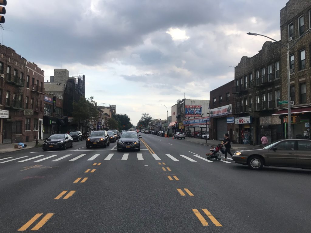
Yes, the DOT made the changes listed above, but the road is still a collection of intersections that are yawning chasms of asphalt with no regard for anything but cars and trucks. The intersection of Avenue P (photo above) is a perfect example: it has not been redesigned since the creation of the priority corridor plan — and, no surprise, the intersection remains just as unsafe as it was: there were 16 crashes, with 21 injuries, from 2013 to 2015, and 15 crashes, with 21 injuries, from 2016 to 2018.
There’s no bike lane on Coney Island Avenue, so beyond a few fire hydrants, bus stops and loading zones, every other inch of the two-lane roadway is devoted to the movement or storage of cars and trucks, a design that encourages drivers to move faster than the city’s 25 miles-per-hour speed limit. Streetsblog saw many cars speeding even with the rampant double-parking along the street.
And double-parking is basically a Coney Island Avenue pastime. Double-parked vehicles — sometimes five or six deep — clog the roadway at all times, consisting of car drivers who are loading their cars, idling, hanging out or merely leaving their cars in the roadway as they wait for space at one of the numerous glass or body shops. The clustering makes it unsafe for cyclists or drivers to negotiate around the parked cars. Moreover, the lack of any buffer between cyclists and the on-street parking creates perfect conditions for “dooring” — being forced into traffic in order to avoid the suddenly open door of an oblivious motorist.
Even with the work that the department did over the past few years, the DOT has left too many opportunities for drivers to behave recklessly and potentially harm pedestrians and cyclists. On our bike ride, we found that cars are allowed to park up to the very inch where crosswalks began — a situation that leaves little to no room for right-turning drivers to see pedestrians crossing in the perpendicular crosswalk. The occasional left turning bay from Coney Island Avenue onto a side street wasn’t much of a panacea either; Streetsblog watched agape as one van driver sped through a left turn when he was about halfway into the bay at the intersection of Church Avenue.
That intersection has seen its share of tragedy this year, in the form of two pedestrian deaths in less than a week’s time in July.
“We don’t want attention — we want change and to make Coney Island Avenue safer for pedestrians and cyclists,” said Fabiola Mendieta, an advocate for the family of Maria Del Carmen Porras-Hernandez, one of the pedestrians killed at Church and Coney Island Avenue this summer.
Drivers should also be agitating for safety improvements to the roadway, such as a crackdown on double-parking, which is not only a danger to cyclists, but creates unsafe conditions for cars and trucks. Standing on Church Avenue and Coney Island Avenue, Streetsblog watched as drivers in the right lane would quickly swerve into the left lane to avoid getting stuck behind double-parked cars in front of a car wash. Double-parked drivers also suddenly pulled into moving traffic, giving the street a constant potential for crashes between two vehicles.
On one day last week, the NYPD did come out in force, with officers from the 66th and 70th precincts pulling over drivers during the morning. But this is rare. Traffic enforcement on along the corridor was also non-existent when it came to the double-parking that made the situation so awful. Some cars do occasionally get tickets, but cars, box trucks, semi-trucks and other vehicles double-parked with impunity.
The problem: Coney Island Avenue is not within any one precinct, but is actually on the border or very edge of five: the 60th, 61st, 66th, 70th and 72nd precincts. As a result, the roadway is like the western frontier, with blurred lines of control and a lack of accountability for tamping down the carnage.
Coney Island Avenue’s problems aren’t unique to it. They can be found at Sixth Avenue and 23rd Street, where Robyn Hightman and Michael Collopy and Melissa McClure were killed. They can be found on Broadway in Brooklyn, another priority district, where Aurilla Lawrence was killed. It’s a problem of the city refusing to take away space from car drivers, no matter how many deaths and injuries they cause. Any changes being demanded by local pols won’t ultimately solve the problem unless there is less space for cars.
So what should be done?
None of this is to say priority corridor extensions can’t work. According to the DOT’s 2019 update to its pedestrian safety action plan, pedestrian KSI went down in 105 out of the 154 corridors that had been identified for the 2015 plan. The agency was able to “delist” 30 out of 96 corridors in Brooklyn and Queens, the two boroughs with most of the corridors in the first plan.
In the 2015 pedestrian safety action plan for Brooklyn, the DOT laid out certain goals for the borough’s priority corridors. One was to “significantly expand exclusive pedestrian crossing time” at every corridor by the end of 2017. The agency also said it would “add exclusive pedestrian crossing time” and “modify signal timing to reduce off-peak speeding” to what it called “all feasible” priority corridors by the end of 2017. The appendix of the 2019 report shows that the agency was able to install LPIs along 43.8 percent of priority corridor miles, retime signals along 82.1 percent of priority corridor mileage and make at least one kind of safety improvement along 92.6 percent of priority corridor mileage.
A spokesperson for the agency defended the work done on the avenue since the priority corridor designation was established: “While we acknowledge that there is more that we need to do on this corridor, DOT has done a great deal of work, completing safety projects every year since 2015, including the installation of left turn calming treatments, Leading Pedestrian Intervals, pedestrian refuge islands, and a new signalized pedestrian crossing.”
The spokesperson also noted that community opposition is still an obstacle on priority corridors, telling Streetsblog that the pedestrian refuges on Roder Avenue, Avenue N and Avenue O “were initially controversial with regard to Hatzolah ambulance response times. We haven’t heard any complaints since installation.”
The DOT has said that it will focus on installing leading pedestrian intervals, pedestrian islands and left turn bays along the block, and study more on safety improvements at six intersections: Avenue L, Avenue C, Dorchester Road, Ditmas Avenue, Quentin Road and Crawford Avenue.
But safe streets activists are swinging for the fences. “Our primary focus is to see Coney Island Ave designed into a complete street similar to Prospect Park West, Queens Boulevard or 1st Avenue in Manhattan,” Cal DeJesus, a co-chair of Transportation Alternatives’ Coney Island Avenue campaign told Streetsblog. Beyond the pedestrian islands and LPIs, activists are asking the DOT for narrower or reduced car travel lanes, protected bike lanes, and more speeding and red light cameras on the street.
“What we want are streets that whether you decide to drive, bike, or walk, you feel safe,” Hercules Reid, the other co-chair of the Coney Island Avenue campaign said. “This is about safe streets, which includes simple things like protected bike lanes and longer walk times for larger streets
“We can do this,” Debbie Herdan, an activist with Families for Safe Streets and Windsor Terrace resident said. “To hear again and again that this impacts traffic flow, is infuriating. We are humans. We are walking, we are biking, and if we’re not more important than the traffic flow, I don’t know what is.”

Read More:

Streetsblog has migrated to a new comment system. New commenters can register directly in the comments section of any article. Returning commenters: your previous comments and display name have been preserved, but you'll need to reclaim your account by clicking "Forgot your password?" on the sign-in form, entering your email, and following the verification link to set a new password — this is required because passwords could not be carried over during the migration. For questions, contact tips@streetsblog.org.