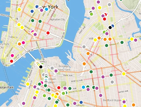
The city has posted an interactive Vision Zero map for New Yorkers to crowdsource incidents of dangerous driving and other street safety conditions that need attention.
"Your knowledge will be used to create a traffic safety plan for each borough that will describe how to make each borough’s streets safer for everyone, whether walking, biking or driving," reads the about tab. The map was developed by DOT, NYPD, and the Taxi and Limousine Commission, in conjunction with OpenPlans, Streetsblog's parent organization.
Shortly after the map went live, broad swaths were covered by multi-colored dots, each representing an observed safety hazard, such as speeding, failure to yield, red light running, and double parking. To submit an observation, users click the "share an issue" button, choose a category, and place a pin on the map where the incident occurred. In addition to motorist violations, there are categories for jaywalking and cyclist behavior, as well as poor infrastructure, including long crossing distances and short pedestrian signal phases.
The map also indicates locations of pedestrian fatalities dating back to 2009. Streets with the highest concentrations of pedestrian-involved crashes in each borough are lined in red.
I took a short walk at lunch today, and as usual saw several drivers putting others at risk. After signing in through Twitter, I chose my category ("other") to note a motorist who encroached on an Inwood crosswalk as a pedestrian tried to cross. I wrote a brief description of what happened (this is optional) and dropped the pin. It took about a minute. Since then others have posted dozens of incidents, and counting.
It's cathartic to be able to document these everyday dangers with the city, particularly since the data will be used to make neighborhood streets safer.
