The L train shutdown plan has arrived.
This afternoon the MTA and DOT released the contours of their plan to keep people moving during the 15-month L train outage west of Bedford Avenue, while the MTA repairs tunnels and tracks damaged by Superstorm Sandy. It's the first real public showing of a replacement transit service plan since Gothamist broke news of the L shutdown nearly two years ago.
The L train disruption will affect hundreds of thousands of daily transit trips, including 50,000 along 14th Street in Manhattan alone. The agencies are counting on increased subway service on the J/M/Z and G trains to handle 70-80 percent of displaced L passengers. But for riders in Manhattan and along the western L train stations in Brooklyn, other subway routes are not a good option.
For these riders, the agencies will beef up travel options by bus, bicycle, and ferry. The outline released today includes substantial transit- and bike-priority treatments, especially on 14th Street. While the plan also calls for bus priority on the Williamsburg Bridge approaches, the details are less specific.
Overall, there's a lot to like in the plan, but it still relies heavily on a straining subway network to carry most of the load. Advocates are not convinced the agencies are doing as much as they should to make bus service fast, reliable, and capable of carrying large numbers of people.
Here's a short review of what we know so far. Streetsblog will publish more detailed analysis in a forthcoming post.
Bus service across the East River
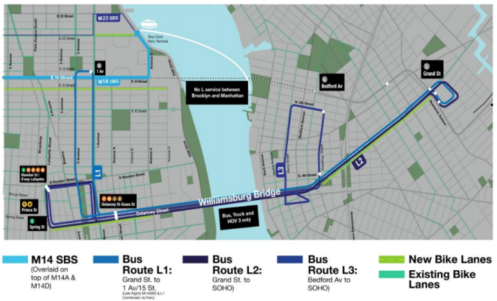
The bus service plan calls for three shuttle routes connecting North Brooklyn and Manhattan.
Two of those routes will have a terminus at Grand Street -- one connecting to 14th Street and First Avenue, the other to the Delancey Street, Spring Street, and Bleecker Street subway stations. A third route would connect the vicinity of the Bedford Avenue L stop with those three subway stations.
The agencies are expecting 3,800 passengers per peak hour on the shuttle services. DOT says fare payment will be the same as Select Bus Service routes, so it looks like ticket-vending machines will be installed on sidewalks.
Combined, these routes will move 70 buses per hour across the East River during peak times, with target end-to-end travel times of about 25 minutes. To keep bus service from getting bogged down in traffic, the city will install bus lanes approaching the Williamsburg Bridge on Grand Street, Delancey Street, Kenmare Street, and Allen Street.
DOT says it is looking "to make major changes" to Grand Street as a "major bus and bicycle corridor," but stopped short of the full car-free "PeopleWay" Transportation Alternatives has called for.
The bridge itself, meanwhile, won't have bus lanes but will be limited to vehicles with three or more passengers -- and trucks. Adjusting the bridge configuration to add more bus priority would be a relatively easy course correction if it turns out to be necessary, however.
Update: DOT sent this clarification about how the bridge restrictions will work in tandem with bus lanes on the approaches:
The outer deck of the Williamsburg Bridge will be for bus, truck and right turns only. (HOV3s will be directed to the outer deck if they wish to turn right at Clinton St, and trucks aren’t permitted on the inner deck.) The bus lanes on the approaches will feed directly into the outer deck, and the HOV3 rules will make the outer deck work reliably for bus passengers.
14th Street transitway, 13th Street bikeway, and pedestrianized streets
A new M14 Select Bus Service line will run from the Stuyvesant Cove Ferry Terminal at East 20th Street down Avenue C and across 14th Street, terminating on the West Side Highway around Horatio Street.
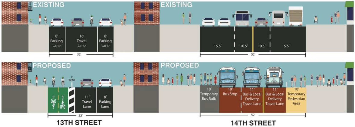
For 14th Street itself, DOT opted for a bus- and local delivery-only street with expanded sidewalks on the busy central section. Eastbound 14th would be only for transit and deliveries from Ninth Avenue to Third Avenue. Westbound it would be from Third Avenue to Eighth Avenue. Conventional bus lanes would also extend east to First Avenue.
DOT will also make two blocks of Union Square West car-free pedestrian zones (between 14th Street to 15th Street and between 16th to 17th). The block of University Place between 13th and 14th would also be pedestrianized with a new bike parking hub.
Instead of including protected bike lanes on 14th Street, as some advocates had hoped, DOT is planning a two-way protected lane on 13th Street. The agency says other bike connections are in the works, but those are not detailed in today's release.
