Real-Time Westchester Bus Info Mysteriously Appears on Google Maps
It’s been four years since the MTA finished rolling out real-time bus arrival information citywide. Riders of Westchester County’s “Bee Line” bus service, meanwhile, are still waiting for bus tracking apps — but maybe not for long. Real-time Bee Line information began popping up sporadically on Google Maps this week. (Hat-tip to the Westchester bus rider who flagged this for us.)
It’s a bit of a mystery, since the arrival information isn’t online anywhere else. The Bee Line mobile app only has maps and schedules, as does the county’s website.
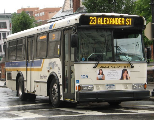
Unlike the MTA, Westchester doesn’t publish the real-time bus data online as an open API, which allows developers at Google Maps and other mobile transit applications to incorporate it into their programs. It’s not clear how Google Maps ended up with Bee Line real-time arrival information, which is only showing up for certain buses, as you can see in this screen-grab from earlier today:
I called up the Westchester County Department of Public Works and Transportation to see what the story is with the intermittent real-time bus info, but got put through to voicemail.
Whatever the explanation, a full rollout of bus tracking capability would soothe the anxiety of 110,000 daily passengers, including many people bound for work in NYC and NYC reverse commuters heading to Westchester.

Read More:
Streetsblog has migrated to a new comment system. New commenters can register directly in the comments section of any article. Returning commenters: your previous comments and display name have been preserved, but you'll need to reclaim your account by clicking "Forgot your password?" on the sign-in form, entering your email, and following the verification link to set a new password — this is required because passwords could not be carried over during the migration. For questions, contact tips@streetsblog.org.
