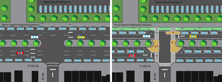
![This road diet and protected bike lane is too much for Queens CB 4 to handle. Image: DOT [PDF]](https://lede-admin.nyc.streetsblog.org/wp-content/uploads/sites/48/2015/04/111th_street_plan.png?w=710)
A dangerous street that Corona residents have to cross to get to Flushing Meadows Corona Park is in line for a serious traffic-calming plan, complete with a two-way protected bike lane [PDF], but local community board members are balking at the proposal.
Flushing Meadows Corona Park, the largest park in Queens, is ringed by highways that cut off access from the neighborhoods around it. The one exception is 111th Street on the west side of the park. But instead of functioning as a welcoming entrance to the park, 111th Street is designed like a surface highway, with three southbound car lanes divided from two northbound lanes by a planted median. Residents have to walk up to 1,300 feet, or five blocks, before finding a marked crosswalk, and 84 percent of cyclists ride on the sidewalk, according to DOT.
Last year, Make the Road New York, Immigrant Movement International, the Queens Museum, and Transportation Alternatives organized for better walking and biking access to the park. Council Member Julissa Ferreras signed on, asking DOT last fall to install bike lanes throughout her district, including on 111th Street [PDF].
The DOT proposal delivers: It would calm the street by narrowing it to one lane of car traffic in each direction. The edge of the street along the park would receive a two-way parking-protected bikeway with pedestrian islands. Moving lanes would be replaced by parking along the median on the southbound side. At intersections, median extensions would shorten crossing distances for pedestrians, which currently stretch up to 94 feet.
This seems to be too much for some key members of Queens Community Board 4.
DOT presented its plan to three members of CB 4 at a special meeting of its transportation committee last Tuesday. “It was definitely a heated, emotional meeting," said Amy Richards, who coordinates the Partnership for a Healthier Queens program at Make the Road New York. The board members were very "change-averse," Richards said. “The meeting was tricky.”
“It’s a tough call,” CB 4 District Manager Christian Cassagnol said of the plan. “We told them to go back to the drawing board and change a couple of the small issues we were questioning.” DOT says it used the feedback to draft minor changes the original plan, which Cassagnol received this morning.
Board members last week were actually looking for major changes to the DOT plan. The big complaint from transportation committee members was "not enough traffic lanes, basically," Cassagnol said. "That seems to be the main thing.”
Without reducing the number of traffic lanes, however, the safety component of the plan would lose most of its impact. 111th Street has no more than 350 cars per hour in either direction during peak hours, DOT said, a level of traffic that is suited for a single lane. But board members said 111th Street needed to keep its car lanes, meeting attendees told Streetsblog, and claimed that large events in the park generate traffic that should weigh more heavily in DOT's analysis.
The CB 4 members' position puts them in opposition to Ferreras and neighborhood street safety advocates. "The council member, while she may be in favor or may not be in favor, DOT wants to make sure that the community board is heard," Cassagnol said, "and we wanted to give them a nudge in the opposite direction."
Advocates say the handful of board members at last week's meeting don't speak for everyone. “From what we’ve heard from the community, there are a lot of people in favor of this plan," Richards said. “The community members that we have been working with have been really excited for the potential to see these changes happen.”
“We were really excited with what DOT presented. We think its a bold vision for using a street that has a lot of wide, unused space,” said Celia Castellan, senior organizer at Transportation Alternatives.
The protected bike lane would be extended southward along the park edge on Corona Avenue, where it will connect with a pedestrian bridge across the Long Island Expressway to Forest Hills. To the north, a combination of sharrows and green bike lanes will route cyclists on 43rd Avenue, 114th Street, and 113th Street to 34th Avenue, where they can connect to bike lanes and a bike path to Citi Field and the Flushing Bay Promenade.
Crosswalks will be added at four intersections -- at 47th, 49th, 54th, and 55th Avenues -- doubling the number of intersections with crosswalks on the park edge between 44th Avenue and Corona Avenue. Pedestrian islands will be added at most crossings between the bike lane and the car lane, with some omitted to provide space for fire trucks and other vehicles making wide turns.
DOT said it could implement the project with paint and bollards this summer, with future phases made out of permanent materials.
DOT is tentatively scheduled to present the plan at the next CB 4 full board meeting on April 14. The public is also invited to participate in a workshop this Sunday hosted by the Parks Department, the Queens Museum, and the Design Trust for Public Space on improving access to and circulation within Flushing Meadows Corona Park.
