Eyes On The Street: Coastal Resiliency Causes Mess For Pedestrians and Cyclists
A city project to save Lower Manhattan from rising sea levels has turned a once-safe protected bike lane into a rolling, multi-year hazard for cyclists and pedestrians.
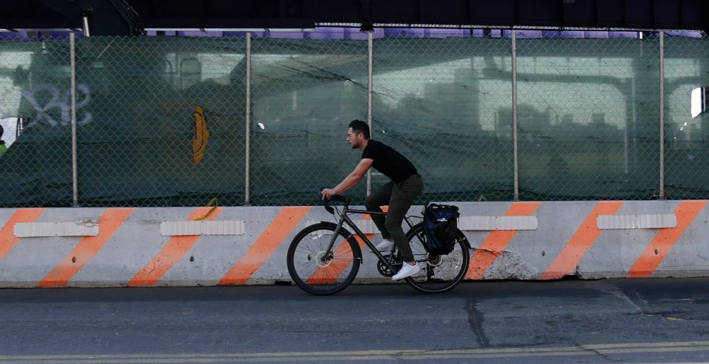
Right now, cyclists looking to use the East River Greenway between Jackson Street and Dover Street must interpret confusing signs, share the road with cars, and share tight space with pedestrians until construction ends sometime in 2026.
“You always feel the difference when you are forced into the street,” said Henry Ertl, who bikes to his office in the South Ferry area three to four times per week.
Ertl remembers how nice the bike lane used to be before the construction started and wonders why more couldn’t be done to make the alternative routes better if the construction will be lasting this long.
“It’s sad to know this will be the case for over a year,” said Ertl.
The Department of Design and Construction has laid out a multi-segment construction schedule for its larger East Side Coastal Resiliency Project, which will build flood mitigation infrastructure to protect the area from storm surge, according to the agency. But during the construction, roadways are unsafe.
On South Street, cyclists are directed in and out of the roadway and drivers going both directions are forced to share one lane at points along the route. However, the FDR will remain open for the duration of construction.
Streetsblog went to check out the situation on the greenway starting at Clinton Street, traveling south towards Lower Manhattan to figure out how this plan is affecting pedestrians and cyclists who are accustomed to the greenway’s protection. The current state of the area pales in comparison to the way things were.
Clinton Street between South and Water streets
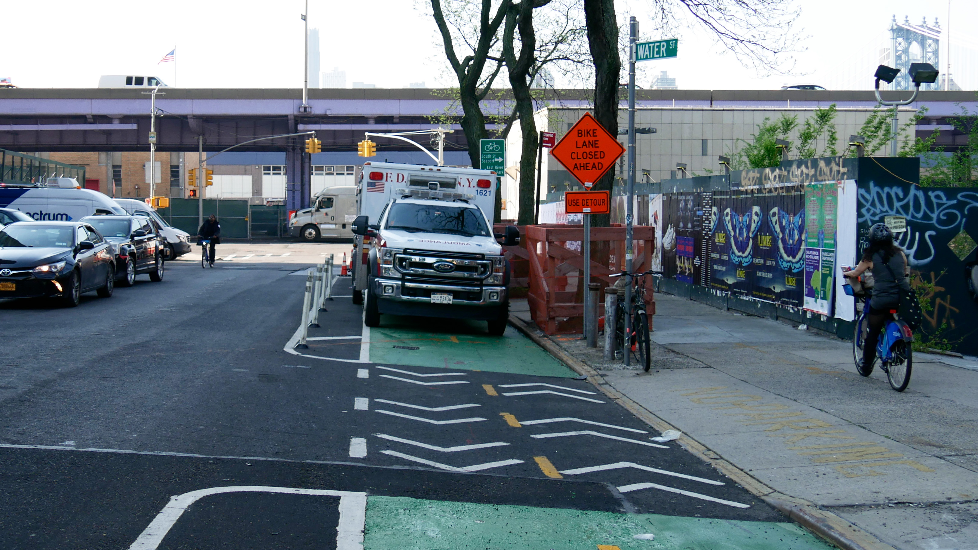
The two-way bike lane on Clinton Street that feeds directly onto the East River Greenway was a de facto holding area for FDNY ambulances from their nearby EMS Station — until Streetsblog started asking officials about it.
Last week, as we were preparing this story, we asked the FDNY why these city vehicles were using the bike lane as free parking, endangering cyclists by forcing them into oncoming traffic.
Agency spokesperson Clare Bourke first said that ongoing construction had limited storage space, but then said the agency has “relocated the ambulances, and they are no longer in the bike lane on Clinton Street.”
South Street between Clinton Street and Rutgers Slip
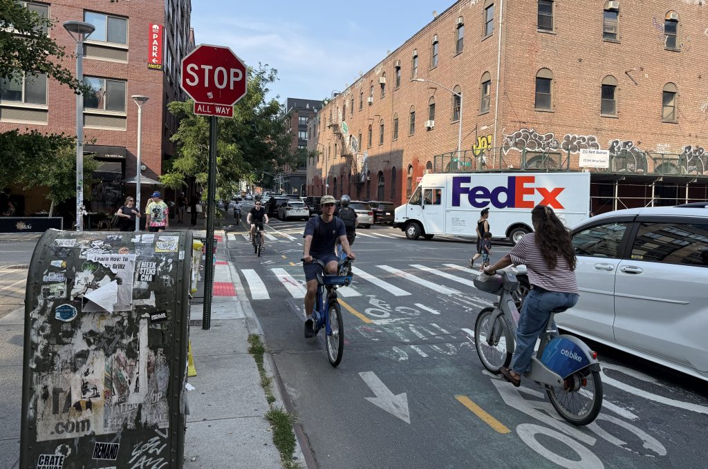
The problems intensify as cyclists take a right from Clinton Street onto South Street, headed towards lower Manhattan. Bikes mix with cars, while pedestrians can stay on the sidewalk or in a protected zone on the roadway, dodging construction materials and staging areas.
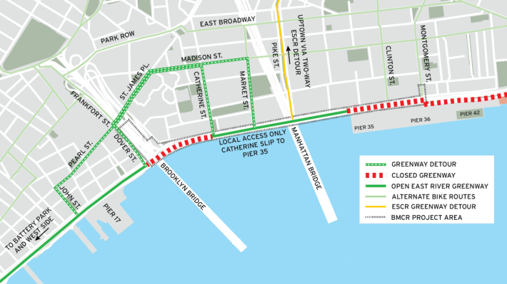
Alternate routes
“Share the road” signs signal that bikes can stay on South Street in both directions, but there are also signs for south-bound riders that allude to another detour. According to DDC’s map, there are multiple options for cyclists, none of which includes a temporary bike lane.
Streetsblog asked DDC and DOT why the agencies did not create a dedicated temporary protected bike lane during construction, which is required under city law — though the law includes a loophole if an agency head thinks a protected bike lane is not feasible at a given location. Sure enough, the agencies cited that loophole:
“DDC’s contractor, in coordination with DOT, determined that there were too many construction-related activities and needs and too many constraints, logistics and safety concerns to include a temporary two-way bike lane through this area,” the agencies said in a joint answer.
Regarding why this particular busy detour was chosen, the agencies blamed the existing city layout: “Due to the old, complex street network in the area, there aren’t alternative parallel routes. The Water/Pearl/St James corridor was identified as the nearest two-way street to safely and consistently detour cyclists.”
The difference between biking on the Water/Pearl/St. James corridor and on a protected bike lane is stark. According to city statistics mapped by Crashmapper, there have been five reported crashes injuring a cyclist and a pedestrian on the alternate route so far this year.
South Street from Rutgers to Catherine slips

If you continue biking on South Street, you get directed onto the pedestrian walkway at Rutgers Slip. From Rutgers Slip to Catherine Slip, cyclists and pedestrians share the path, with signs telling cyclists to yield to pedestrians and, at the same time, prompting them to leave the path to go to the “detour,” which is the Water/Pear/St. James corridor.
Catherine Slip
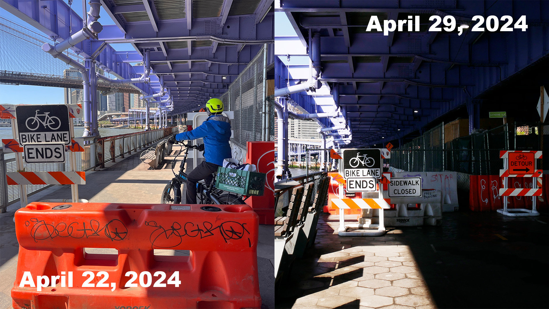
Assuming you stay on the pedestrian path, it ends for both walkers and cyclists once you hit Catherine Slip. However, last week, when Streetsblog visited the area, the barrier was open so pedestrians could continue through. Even though there was a sign that said “bike lane ends,” most cyclists were continuing through since the space was open. Now, it seems more construction has begun so the pedestrian path is completely blocked to everyone.
Currently there is no safe alternative.
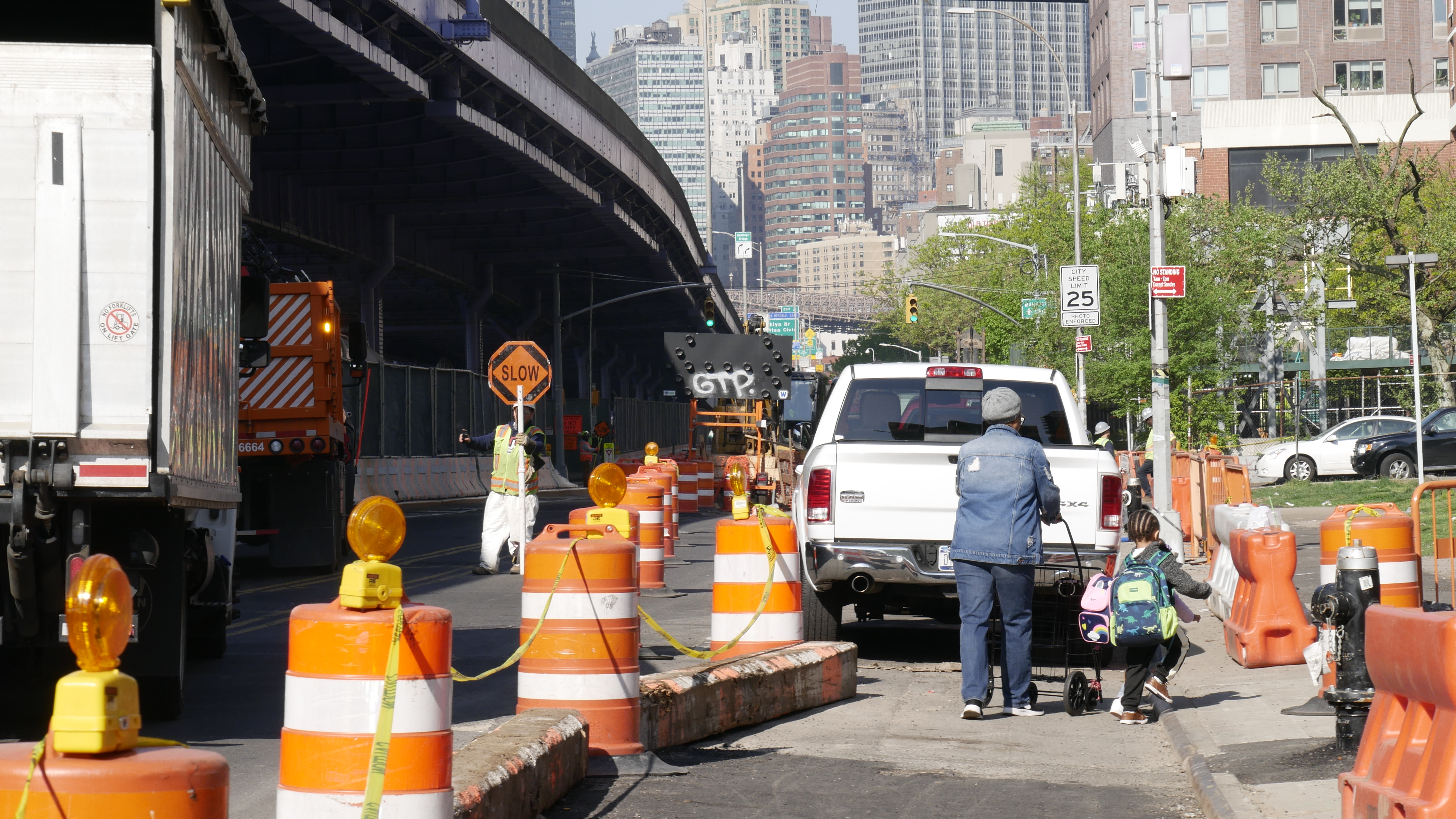
From Catherine Slip to the Brooklyn Bridge
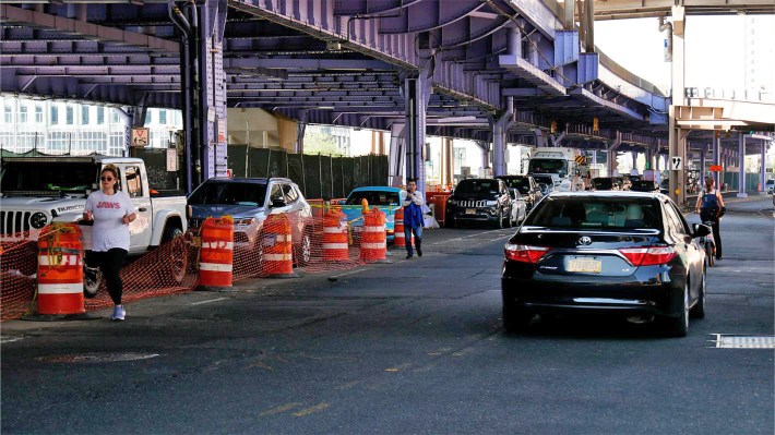
After pedestrians get back onto the sidewalk and cyclists into the road at at Catherine Slip, they are faced with a very dangerous situation as they approach Robert F. Wagner Sr. Place, just under the Brooklyn Bridge. Construction forces pedestrians and cyclists heading to lower Manhattan to cross South Street with no protection if they want to get back onto the East River Greenway where it re-opens. All the while, vehicles park along South Street, protected by safety cones, while pedestrians and cyclists dodge traffic.
Unfortunately for cyclists and pedestrians looking to use the greenway, this situation will be the case until construction ends, which DDC and DOT say won’t be until “at least 2026.”

Streetsblog has migrated to a new comment system. New commenters can register directly in the comments section of any article. Returning commenters: your previous comments and display name have been preserved, but you'll need to reclaim your account by clicking "Forgot your password?" on the sign-in form, entering your email, and following the verification link to set a new password — this is required because passwords could not be carried over during the migration. For questions, contact tips@streetsblog.org.