Op-Ed: These Five Manhattan Streets Need Safety Fixes Now!
Many cheered last month when the city finally got around to fixing the notorious “Second Avenue Gap” in bike-lane coverage from 59th to 68th streets in Manhattan — an area long known as a death trap for pedestrians and cyclists.
But that project represents only the smallest part of the street redesigns that the city must undertake in order to put a dent in the enormous number of crashes and fatalities in its Central Business District. In the last five years, Midtown and the adjacent neighborhoods of Hells Kitchen/Midtown West and the Upper East Side had almost 8,000 crashes, with 46 fatalities and almost 10,000 injuries. That’s a rate of almost six crashes a day and more than nine deaths a year. So much for “Vision Zero.”
Even though Manhattan is the richest borough in terms of protected bike lanes and pedestrian carve-outs, one need only look to the left and right to see roads that endanger cyclists and intersections that require pedestrian improvements. This situation constitutes an enduring shame in a city that considers itself a world capital, and the Department of Transportation ought to rectify it forthwith.
Here are five dangerous stretches of road that are on every Manhattan safe-streets activist’s fix-it “wish list”:
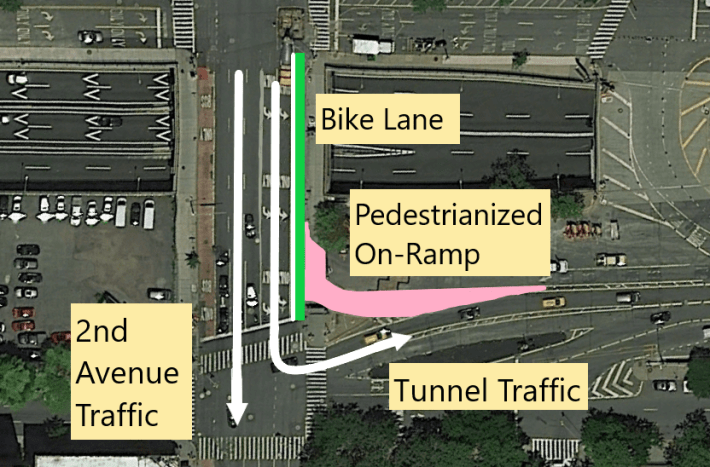
Second Avenue from 43rd Street to the Midtown Tunnel
Even as DOT filled the northern “Second Avenue Gap,” the road southbound remains as dangerous as ever near the Midtown Tunnel, where, just like previously up north, cyclists and pedestrians must fend for themselves in horrendous traffic. The city needs to install a protected bike lane southbound, stat!
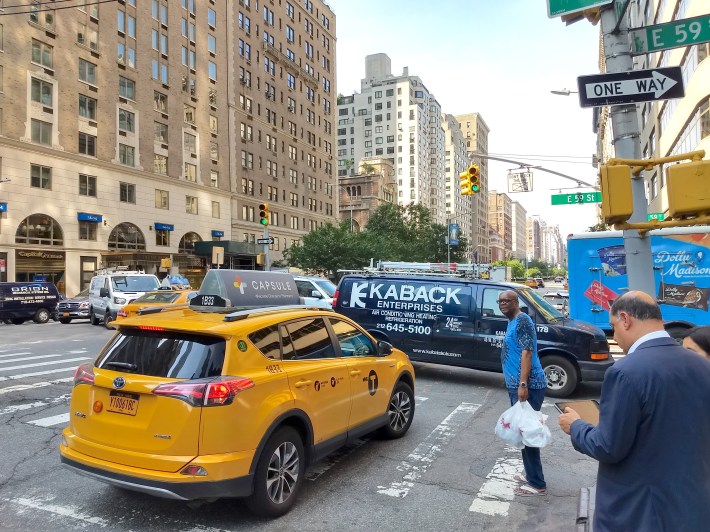
Third Avenue From 34th to 59th Streets
Third Avenue serves as an “escape route” for many Queens-bound drivers by virtue of it being the nearest northbound avenue west of the 59th Street Bridge. This function comes at the expense of pedestrians, bus passengers, and cyclists, who easily outnumber drivers along the corridor.
At its busiest stretches in Midtown, Third Avenue hosts four northbound traffic lanes, with scant accommodation for other users. An often-blocked bus lane provides little relief to riders. Pedestrians have virtually no protection when crossing the street, the only true area of respite between regular and bridge-bound traffic being a bus-stop island at 57th and Third.
Cyclists, meanwhile, must maneuver carefully as drivers battle for lane positions.
A bit of everything is needed to fix this. A protected bike lane is a must, along with expanded sidewalks in order to accommodate rush-hour crowds, especially near the subway entrances at 53rd and 60th Streets.
Managing bridge-bound traffic will be tougher, especially where Third Avenue splits to separate traffic, but the bus-stop island at 57th could be extended north two blocks to 59th Street, where Third Avenue traffic is already split by bollards.
Fifty-Ninth Street from Third Avenue to Columbus Circle
Traveling west along 59th Street yields at least three unsafe bottlenecks. At Park Avenue, when bridge-bound traffic is at its worst, constant backups force pedestrians and cyclists to navigate an ever-moving (and stopping) maze of cars, trucks, and buses.
At Fifth Avenue, where 59th and 60th streets combine to form Central Park South, the sheer volume of traffic, combined with the large crowds of pedestrians using cramped sidewalks, can create dicey conditions even at less busy times of day.
At Sixth Avenue, where northbound traffic has to turn either east or west, the lack of clear lane demarcations creates a free-for-all as drivers frantically jockey for position, making crossing Central Park South dangerous for pedestrians and cyclists.
Many fixes are needed here. At Sixth Avenue, DOT should place bollards, like those on Third Avenue, in order to clearly separate traffic heading east or west. At Fifth Avenue, it should pedestrianize 59th Street’s westbound lanes from the Plaza Hotel through Grand Army Plaza. At Park Avenue, the city should station a traffic cop in order to direct drivers not to “block the box.”
And it must install a protected bike lane along the entire corridor. A two-way bike lane could be put on the park side of Central Park South, then extended along 60th Street to connect to the shared pedestrian/bike path that runs across the Queensboro Bridge.
Broadway from Columbus Circle to 58th Street
The city has improved Columbus Circle in the last few months. There’s now a protected bike lane along the innermost part of the circle (it’s a bad spot, but whatever); that lane, combined with pedestrian improvements, such as curb extensions, make it much safer.
The circle is still one grand bottleneck, however, with cars entering and exiting through five different streets and avenues. One way to simplify it would be to close Broadway to traffic from the circle from 59th Street to 58th Street.
Eighth Avenue: All of it
Eighth Avenue is a textbook example of what happens when a lack of space impedes street improvements. In this case, the victim is the Eighth Avenue protected bike lane, which runs from 13th Street to Columbus Circle with an interruption around the Port Authority Bus Terminal. Although the bike lane is useful, sidewalks on Eighth Avenue are so thin in some places — especially in the Theater District — that pedestrians, inevitably, spill over into the bike lane.
DOT is slowly starting to address the problem with a plan that seeks to narrow the avenue and expand sidewalks from about 37th Street through 42nd Street near the Port Authority Bus Terminal. But sidewalks should be expanded along the whole avenue from Chelsea to Columbus Circle.
So while New Yorkers appreciate the improvements DOT endeavored during the last few years, we need more — much more.
We’d like to see a systematic strategy — wasn’t that what Vision Zero purported to be? — to make Manhattan less of a crowded mess, instead of the piecemeal approach that the city seems to be taking. It may give an avenue a protected bike lane, or a decent bus lane, or ample pedestrian space, but rarely does it fashion complete “safe streets.” Congestion pricing, which should remove some cars from our choked Central Business District, won’t better the awful infrastructure.
DOT, get to it.
Liam Jeffries is a safe-streets activist and freelance writer in Manhattan.

Read More:

Streetsblog has migrated to a new comment system. New commenters can register directly in the comments section of any article. Returning commenters: your previous comments and display name have been preserved, but you'll need to reclaim your account by clicking "Forgot your password?" on the sign-in form, entering your email, and following the verification link to set a new password — this is required because passwords could not be carried over during the migration. For questions, contact tips@streetsblog.org.