Sorry Bus Stops, Round 1: San Rafael vs. Vancouver
We have a truly jaw-dropping set of bad bus stops for you today as we continue first round action in our Sorriest Bus Stop in America competition.
Today’s Sweet 16 match pits two West Coast contenders, one from the Bay Area and the other from Vancouver, B.C.
Nashville, Cincinnati, Beverly Hills, Pittsburgh, and McKees Rocks have already advanced into the second round. Voting is still open in yesterday’s matchup: Miami vs. New Orleans. Now for today’s competition …
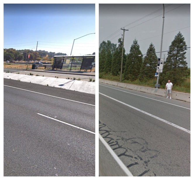
San Rafael, Calif.

This bus stop, on Hwy 101 at Smith Ranch Road, was submitted by reader Kevin Carstens. He writes:
While the stop itself is nice (with a shelter and lighting), it is in a high capacity corridor (four-plus buses per hour throughout the day with extra during the peak hours; nine buses I think during the 6 p.m. hour). Despite this, it is sandwiched between ramps adjacent to a noisy eight-lane freeway with very poor connections to the surrounding areas. Riders have to tackle narrow sidewalks, dangerous and fast ramps, and lack of sidewalk amenities (curb ramps, lighting, … width…). In particular, look to the south of the stop, where a three-foot sidewalk crosses an off-ramp without any sort of signage or striping, pitting pedestrians against vehicles flying off the freeway. Additionally, while the matching southbound stop is only 250 feet away as the crow flies, it is 1,700 feet as the ped walks. Or 1,300 feet if a ped takes the dirt path shortcut from the southbound stop, across the off-ramp, to Lucas Valley Road.
Here’s an aerial view of this bus stop, which helps provide better perspective.

The stop is served by Golden Gate Transit and Marin Transit, it even has a park and ride, as you can see.
These agencies and Caltrans need to get together and figure out a way to make stops like this safer.
Pitt Meadows (near Vancouver), B.C.

This hair-raising bus stopis located at Lougheed Highway and Old Dewdney Trunk Road in Pitt Meadows, on the outskirts of Vancouver. It was submitted by Jason Lee, who explains:
Lougheed Highway is a major arterial linking Vancouver’s exurbs with its inner-ring suburbs. It is also one of the most dangerous in British Columbia — ranking second in the entire province with 33 fatal crashes over the 10-year period between 2004 and 2013. Translink, Vancouver’s well-respected transit agency, has been investing a lot of service in suburban areas, with impressive ridership growth. The routes that serves Lougheed Highway — the 701 and express companion, the 791 — together provide service at least every 15 minutes or better, seven days per week, serving over 8,600 trips on an average weekday. Bus stop 61452 [pictured above], located in the westbound direction of Lougheed Highway and Old Dewdney Trunk Road, is a major safety hazard. At that point, Lougheed Highway consists of four lanes in each direction (one of which is a bus lane), with speeds of 50 mph or higher. The bus stop pole is located atop a jersey barrier, which serves as a buffer between speeding cars and the edge of the roadway. Transit riders are forced to either a) wait on the other side of the jersey barrier, and then climb over it when the bus arrives, or b) wait on the highway side of barrier, directly exposed to traffic. Riders in wheelchairs must wait on the highway side of the barrier. The roadway can also be slick; that part of British Columbia’s Lower Mainland receives nearly 58 inches of precipitation per year, most of it concentrated during the dark winter months. This bus stop is a disaster waiting to happen. In my three decades of riding transit, I have never seen a bus stop designed like this. During my journey on the 701 less than two weeks ago, I saw a group of people climb over the jersey barrier to get on the bus. They appeared to be non-English speakers who were carrying buckets of berries they had harvested, captive riders who could easily have become the latest victims of speeding cars along Lougheed Highway.
The highway in this case is managed by the British Columbia Ministry of Transportation. But the larger issue is clear: Sorry bus stops are not just a U.S. problem, eh?

Read More:
Streetsblog has migrated to a new comment system. New commenters can register directly in the comments section of any article. Returning commenters: your previous comments and display name have been preserved, but you'll need to reclaim your account by clicking "Forgot your password?" on the sign-in form, entering your email, and following the verification link to set a new password — this is required because passwords could not be carried over during the migration. For questions, contact tips@streetsblog.org.