Envisioning a Regional Trail Network Radiating From the Heart of NYC
The Regional Plan Association is proposing a 1,625-mile network of biking and walking trails linking New York, New Jersey, and Connecticut [PDF], which the organization unveiled last week as it previews components of its Fourth Regional Plan, due for release later this year.
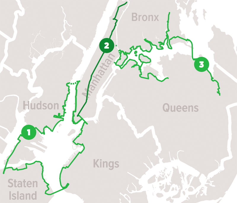
Within New York City, RPA’s trail plan calls for 45 car-free blocks of Broadway and a continuous bike route along the spine of Manhattan, a bicycle path on the Verrazano Bridge, and greenway connections linking the Bronx, Brooklyn, and Queens to Nassau and Suffolk.
The Verrazano bike path, which advocates have been pushing the MTA to build, is the key missing link in the proposed 43-mile Harbor Ring greenway connecting Manhattan, Brooklyn, Staten Island, and Hudson County.
The 13-mile “Manhattan Trail” would consist of a car-free Broadway between 14th Street and 59th Street, with safety improvements extending on the street network south to the Battery and north to the High Bridge.
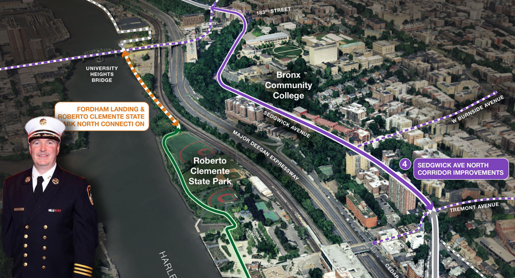
A 55-mile “Inner Sound Shore Loop” would connect greenways in the South Bronx and northern Queens via the Triboro Bridge and Throgs Neck Bridge. The loop would link to Brooklyn and Long Island greenways via the “Long Island Motor Parkway Trail” — portions of which currently exist in fragmentary form.
Of all 1,625 trail miles in RPA’s plan, 50 percent already exist and another 27 percent are proposed or in progress. The completed network would put 8 million of the region’s 20 million residents within a half-mile of a trail, up from about 5 million today.
The trail network would be accessible from and improve access to the region’s transit network. There would be 111 regional rail stations, 237 NYC subway stations, and 13 PATH stations within a half-mile of a trail.
While much of the trail network is in place or underway to some degree, completing the whole plan won’t be easy. In addition to the usual hurdles of funding and acquiring right-of-way, a network of this scale will involve coordination between a large number of different public agencies and jurisdictions. To accelerate the process, RPA suggests forming a regional coalition of trail-building organizations, land trusts, and local governments to steer the effort, from fundraising to construction.

Read More:
Streetsblog has migrated to a new comment system. New commenters can register directly in the comments section of any article. Returning commenters: your previous comments and display name have been preserved, but you'll need to reclaim your account by clicking "Forgot your password?" on the sign-in form, entering your email, and following the verification link to set a new password — this is required because passwords could not be carried over during the migration. For questions, contact tips@streetsblog.org.