DOT Proposes Safer Walking and Biking Connections to Highland Park
A dangerous street that connects Glendale to Ridgewood Reservoir, Highland Park, and two cemeteries is in line for traffic-calming and safer bike lanes thanks to a request from the local police precinct [PDF].
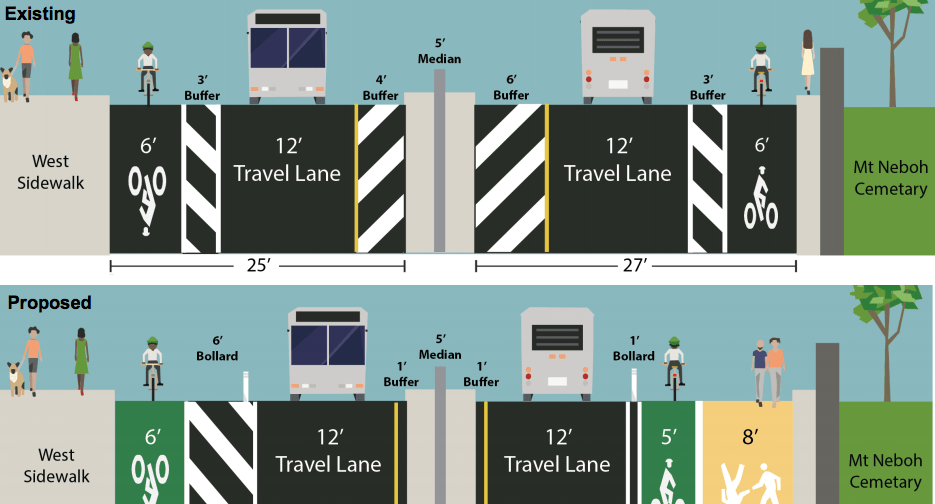
Cypress Hills Street has a divided median and highway-like curves that do little to prevent motorists from speeding. The street is an obstacle to good walking and biking access, despite its buffered bike lanes. The east curb, which runs along a tall concrete barrier, has five B13 bus stops — but no real sidewalk.
It’s not safe for people in cars either: Since 2010, two motor vehicle occupants have been killed in crashes on this stretch, according to DOT. Another six were severely injured.
Between Cooper Avenue and Jackie Robinson Parkway, the project would shrink the striped median to make way for an eight-foot-wide painted sidewalk on the east curb. The bike lanes would be painted green and protected by plastic bollards, though the buffer on the east side would be narrowed.
At bus stops, the protection would give way and buses would pull to the curb. The 78th Avenue bus stop would be eliminated, simplifying the intersection while consolidating stops in an area that currently has three within 870 feet. The four remaining northbound bus stops would all get concrete bus bulbs.
The bike lanes would terminate at Jackie Robinson Parkway, where a new crosswalk would guide cyclists coming over the highway onto a service road connecting to Highland Park. The service road travel lanes will be reduced from 15 feet wide to 12 feet, with signage directing cyclists to ride on the sidewalk, which is the official bike route.
DOT reps presented the plan to Queens Community Board 5’s transportation committee on April 25. Thanks in part to that support from the 104th Precinct and local civic organizations, who responded positively to the plan, the committee endorsed the project.
“The transportation committee has been really focused on generating better access to Ridgewood Reservoir,” co-chair Toby Sheppard Bloch told Streetsblog. “Both the neighbors who live nearby and the precinct have highlighted the need for it.”

Read More:
Streetsblog has migrated to a new comment system. New commenters can register directly in the comments section of any article. Returning commenters: your previous comments and display name have been preserved, but you'll need to reclaim your account by clicking "Forgot your password?" on the sign-in form, entering your email, and following the verification link to set a new password — this is required because passwords could not be carried over during the migration. For questions, contact tips@streetsblog.org.