Can Algorithms Design Safer Intersections?
Cities and tech firms are deploying new technology to gauge risks at dangerous intersections. These sensors, cameras, and machine-learning algorithms are promising, especially when it comes to measuring close calls that don’t result in crashes — but the applications of this information are still getting fleshed out. In the meantime, there’s no reason to wait on designing safe streets.
Since March, sensors and cameras have been deployed at the intersection of Massachusetts Avenue and Beacon Street in Boston, a dangerous crossing where volunteers installed pop-up safety improvements after a cyclist was killed by a driver in 2015.
The monitoring equipment is part of a partnership between Verizon and the city of Boston announced last year, reports Elizabeth Woyke at MIT Technology Review:
Verizon outfitted the intersection with 50 cameras and sensors, including “quad cameras” — each containing four smaller cameras that can pan, tilt, and zoom in different directions — and infrared cameras that can do thermal imaging, which is useful for discerning traffic activity in snow and rain. Below ground, Verizon installed dozens of magnetometer sensors that detect the velocity, number, and size of passing cars, trucks, and buses by registering a change in frequency when large metal objects move over them. Since most bikes don’t have enough conductive material to trigger the magnetometers, the site also has radars for sensing bicyclists.
This data is combined with bus location data and information on traffic signal phases to identify potentially dangerous interactions. The city has a few months of data and is still figuring out how to use it.
“We are currently working with Verizon to ensure that the data being collected by the sensors is reliable and can be displayed visually in a way that is useful for planners and engineers here,” said Vineet Gupta, director of planning at the Boston Transportation Department. “They can give us information about the speed of oncoming vehicles approaching the intersection, or they can give us data on near-misses… It’s those kinds of subtleties that will help us get a good understanding of the intersection.”
So far, the data is being used to assess red-light running and encroachment by drivers into the bike lane, Woyke writes. Eventually, the city hopes to expand the sensor program to six additional intersections along Massachusetts Avenue.
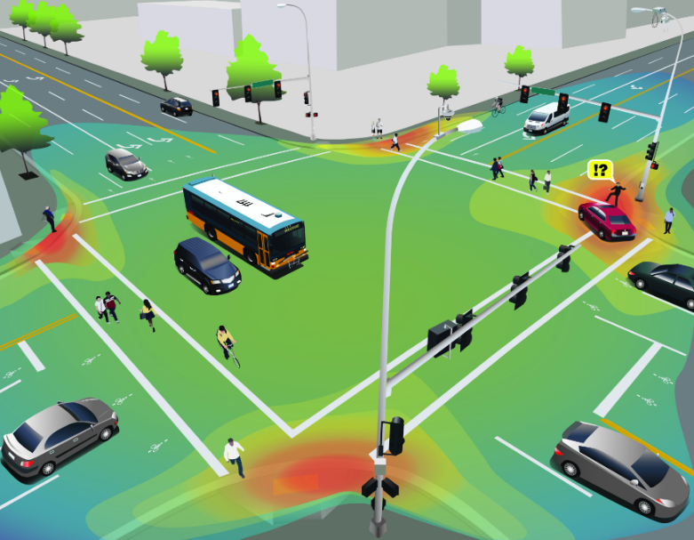
On the other side of the country, in Bellevue, Washington, an effort is underway to use existing traffic cameras — no additional sensors required — to measure intersection dangers. The city has partnered with Microsoft and the University of Washington to feed visuals from its traffic cameras into an algorithm that can tally the number and types of vehicles in an intersection, as well as their direction and speed, to identify collisions and near-misses. The project relies on volunteers to help the algorithm begin its machine learning — or as Doug Trumm at The Urbanist puts it, “unpaid labor benefiting one of the region’s largest corporations.”
Developing better tools to assess the threat of poor street design and bad driving may help fine-tune safety improvements or show why street redesigns are necessary, but what’s really in short supply isn’t information so much as political courage to implement changes, says Tom Fucoloro at Seattle Bike Blog:
We already know, for example, that a wide curb radius encourages people driving to take turns too quickly and too close to people walking. Each of the red areas [in the top image] above could be addressed by extending the curbs closer to the center of the intersection or by installing a protected intersection…
But will Bellevue (or any other city that uses this technology) have the guts to redesign their intersections to put the safety of people walking above the desire for quick turns? Hopefully this data can help convince leaders, but well see.
Advocates in Boston have been pushing the city to make the hard choices necessary to improve safety on its streets, as well, including at Massachusetts Avenue and Beacon Street, but have so far been disappointed at the pace of change.
There are some things you don’t need an algorithm to figure out.

Read More:
Streetsblog has migrated to a new comment system. New commenters can register directly in the comments section of any article. Returning commenters: your previous comments and display name have been preserved, but you'll need to reclaim your account by clicking "Forgot your password?" on the sign-in form, entering your email, and following the verification link to set a new password — this is required because passwords could not be carried over during the migration. For questions, contact tips@streetsblog.org.