Behold the First Bike-Share Expansion Maps of 2017
DOT has released preliminary station locations for two areas in this year’s Citi Bike expansion. The maps will be finalized by June, agency reps told the Brooklyn Community Board 9 transportation committee last night. (The process of locating the new stations began with public workshops in the fall.)
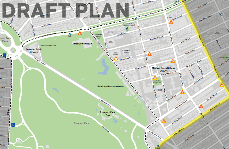
The expansion into Prospect Heights, Crown Heights, and Prospect Lefferts Gardens will extend to Rogers Avenue. This won’t reach as far east as the system does in Bedford-Stuyvesant, where stations are located up to Malcolm X Boulevard.
DOT presented 10 station locations in its draft map for CB 9 [PDF], which covers a relatively small area between Eastern Parkway and Lefferts Avenue. The station density works out to a healthy 38 per square mile if you don’t count the Brooklyn Botanic Garden and Prospect Park, but all 10 stations will be located on sidewalks.
DOT also presented its draft Astoria map to Queens CB 1 on Tuesday [PDF]. That zone cover a larger area (three square miles) and will be getting 59 stations. That comes out to about 19 stations per mile, significantly less than the 28 recommended by the National Association of City Transportation Officials.
In Manhattan, Citi Bike will be expanding from 110th Street to 130th Street. Those station maps were released last year.
Parts of Queens CB 2 and Brooklyn CB 8 are also included in the expansion. DOT will present draft station maps to Brooklyn CB 8 on April 25, according to DNAinfo, and to Queens CB 2 next month. The new stations will be installed by the end of the summer.

Read More:
Streetsblog has migrated to a new comment system. New commenters can register directly in the comments section of any article. Returning commenters: your previous comments and display name have been preserved, but you'll need to reclaim your account by clicking "Forgot your password?" on the sign-in form, entering your email, and following the verification link to set a new password — this is required because passwords could not be carried over during the migration. For questions, contact tips@streetsblog.org.