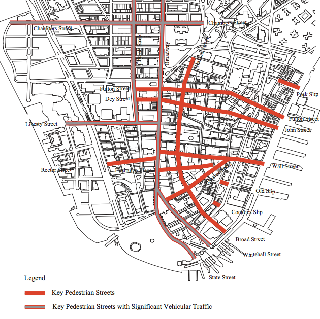
For people in cars, the Financial District is a slow-speed maze. For everyone else, it is one of the city's most transit-rich destinations. Despite this, most of the street space in the area is devoted to cars.
The Financial District is an ideal candidate for pedestrianization, but while it has seen redesigns on a handful of streets, it has yet to see the large-scale creation of car-free space that has been studied and talked about for ages. Could introducing shared space to the mix help transform some of New York's oldest streets into truly people-first places?
If not for the the Brooklyn-Battery Tunnel, the Financial District would effectively be a large cul-de-sac -- there is no reason for through traffic to use its local streets. The evil twins of West Street and the FDR Drive feed cars to the tunnel and ring off the neighborhood from the waterfront. But within the Financial District itself, most of the streets are narrow and have far more pedestrians than cars.
There are a few places in the Financial District where car-free streets have taken hold over the years. Too often, the goal has been not to create an open, accessible city, but to build a fortress against the threat of truck bombs.
Blocks near the New York Stock Exchange are closed to through traffic, but pedestrians continue to be shunted to the margins, especially along Broad Street. Screening checkpoints have turned deadly, with one driver killing a 70-year-old man on the sidewalk next to a Broad Street security gate two years ago.
At the World Trade Center site, pedestrians are only now allowed to walk right up to the memorial after years of ticketing and security clearances. Neighbors objected that the long-term security plan for the site was too intrusive, but their lawsuit was dismissed. Ultimately, Greenwich Street will be restored and closed to motor vehicle through traffic -- cyclists may have to dismount and walk through security stations -- but there will still be spaces where pedestrians are prohibited to make room for vehicle access and drop-offs, even though the area is expected to be flooded with people.
Even without security barriers, many of the neighborhood's streets see very light car traffic, yet push people to the margins. There are exceptions: Stone Street's picturesque restaurant row serves as a happy hour beer garden and South Street Seaport attracts tourists and shoppers, while a block-long pedestrian plaza was installed last year at Coentis Slip. Painted additions near Bowling Green have created space for pedestrians who had been flowing off the sidewalk, but the fundamental layout of the street remains the same, with car traffic gobbling up the center.
Before 2001, sections of Fulton and Nassau Streets were pedestrian-only during parts of the day. A 1997 Department of City Planning report on pedestrianization in Lower Manhattan [PDF] documented the success of that arrangement. "Pedestrian volumes are high and narrow sidewalks contribute to failing levels-of-service," the report said. "The pedestrian mall attracts high midday pedestrian volumes."

Last year, DOT's Sustainable Streets report singled out the Financial District as a "strong candidate" for more pedestrian-friendly streets. "The City could consider creating a wider pedestrian precinct on additional smaller streets, with freight delivery access during specific off–peak windows," the agency said. "Shared streets -- pedestrian streets with very slow vehicle access -- could complement or be central to such an initiative."
Pioneered by Dutch traffic engineer Hans Monderman, shared space (known in Dutch as a "woonerf") is borne of the philosophy that people can navigate public space on their own, rather than relying on markings and signs to divide and mediate the right-of-way between cars, cyclists, and pedestrians.
It fundamentally challenges the typical battle over street real estate. By having road users negotiate each and every interaction with another person, it compels everyone to pay attention and goads drivers to reduce speeds below 20 mph. From a driver's perspective, shared space is an appealing concept in part because it improves efficiency by eliminating queues at traffic lights.
Ben Hamilton-Baillie is an English urban designer specializing in shared space projects. He gave a presentation on the concept to the Congress for the New Urbanism in Buffalo last month. Asking city streets to perform two functions -- one with civic space like sidewalks and plazas, the other a highway-like design with lanes and signage -- creates a place that doesn't perform either task particularly well, he said.
While many might think that streets with lots of pedestrians and little car traffic would be the only suitable place for shared space, Hamilton-Baillie has focused his recent work on streets with a steady flow of cars. He points to a busy intersection he redesigned in Poynton, England, as a success story. While New York might not want to begin right away with shared space treatments on a car sewer like Tenth Avenue, the Financial District's narrow streets are an obvious place to start. A potential selling point: Shared space allows a street to maintain vehicle access while gaining many of the benefits of pedestrianization.
"Shared space as an idea is something that we all have to get educated about," said Ethan Kent, senior vice president at Project for Public Spaces. While there are only a few places in New York specifically designed as shared space, Kent said that many of its principles are already in action on the city's pedestrian-heavy, human-scaled streets, like those in Chinatown and the Meatpacking District. "New York's most valuable destinations are essentially shared spaces. Look at Rockefeller Center," he said. "We should study the best streets in New York."
Last month, Hamilton-Baillie met with Transportation Commissioner Polly Trottenberg and urban design staff from DCP at DOT's headquarters in the Financial District. Kent was also at the meeting. "It could be an evolution of the public plaza program, but it can also be implemented independently as a better street design, as a better way to slow traffic on a street," he said. "There are definitely opportunities to apply it."


