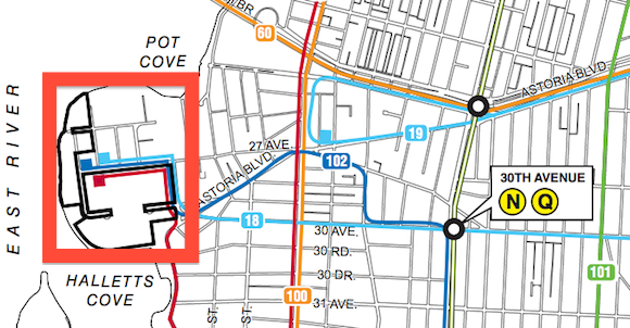
Development plans for a stretch of the Queens waterfront would add new retail and more than 4,300 new residences a mile and a half from the nearest subway station. So far, the only transportation plan for these new residents consists of more than 2,300 parking spaces and suggestions for expanded bus and ferry service.
Unless the city can come up with a better transportation plan, Council Member Peter F. Vallone, Jr. says he won't guarantee his support for the first of the developments as it moves along the city's land use approval track toward the City Council.
There are two projects under consideration in the area. Halletts Point, which has been under discussion for years and is already on its way to receiving land use approvals, would bring 2,644 residential units, a new supermarket, and approximately 1,400 parking spaces to what is now industrial land and the adjacent grounds of NYCHA's Astoria Houses. A second project, the recently announced Astoria Cove, is slated for industrial land immediately to the northeast and consists of 1,701 residences, retail space, and 940 parking spaces.
According to the draft environmental impact statement for the project, Halletts Point is expected to generate about 1,000 new car trips, 1,200 subway trips, and 200 bus trips each rush hour. Because most subway riders are expected to use the bus to access the nearest train stations, the project would lead to overcrowding on the Q18, Q102, and Q103 buses, which are the only lines serving the area.
While existing bus service would be overwhelmed, the projected split between cars and transit still tilts far more heavily toward cars than the rest of the 11102 zip code, where only 19 percent of commuters drive or carpool, and almost 70 percent take transit, according to 2011 five-year estimates from the Census.
Solutions to make the developments less auto-dependent are threadbare. Astoria Cove developer Alma Realty, which helped defeat a pedestrian plaza on Newtown Avenue last year, has said it would provide private van service to the subway for its residents. Another proposal, favored by the Economic Development Corporation, is expanding East River Ferry service, which has a $4 fare and receives high per-passenger city subsidies that come to about $3 million annually. The EDC is searching for ways to fund ferry service to Halletts Point, but so far, no money has materialized.
As for buses, the draft EIS suggests adding extra runs to existing lines but notes that any new bus service is dependent on the funding and operational constraints of the MTA, which has not promised any new service to the area. (Further south, in Williamsburg, residents of another new waterfront residential zone have lobbied the MTA for new bus service that is scheduled to start this September.)
In Astoria, few officials are questioning the wisdom of rezoning flood-prone industrial land far from the subway for thousands of new apartments. "That peninsula needs development, everyone agrees on that," Vallone told Streetsblog. "Both the mayor and the speaker have made this development a hallmark of their terms."
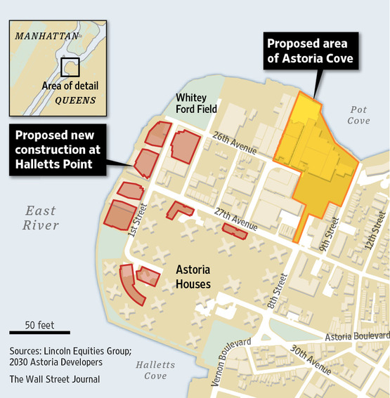
The Bloomberg administration has been a big booster of waterfront residential development, even in the face of concerns about climate change and storm surges, with its Greenpoint-Williamsburg rezoning yielding new residential towers along the East River. But most of the Astoria waterfront was excluded from the neighborhood's rezoning in 2010, so Halletts Point and Astoria Cove must request separate zoning changes for their projects.
The Halletts Point plan has already received support from Community Board 1 and awaits comments from Borough President Helen Marshall before going before the City Planning Commission and eventually the City Council, where Vallone has a card to play: The City Council usually follows the lead of the local council member when it comes to approving land use requests.
"I am concerned that at this late date, they have not come forth with a concrete plan to provide transportation that this development would need," he told Streetsblog, saying that he wants an "ironclad agreement" for expanded bus and ferry service. "The city and the MTA would have to provide more transportation alternatives," he said.
But if the city and the MTA fail to commit to bus and ferry expansion, is Vallone willing to block the project when it reaches the City Council? "Unless I get a plan from the city, I cannot promise my support," he said. "It's going to be a very involved decision which I have not made yet."
