Yesterday at the Municipal Art Society Summit, three architecture firms -- Foster + Partners, Skidmore, Owings & Merrill, and WXY architecture + urban design -- unveiled proposals to remake public space in Midtown East, as the Bloomberg administration sets out to rezone the area for taller towers.
The rezoning covers a large swath of Midtown, aiming to take advantage of new transit capacity as the Second Avenue Subway and the LIRR's East Side Access project bring more people to the area. In an interesting twist, the administration wants developers to pitch in for pedestrian improvements as the area becomes a bigger destination for people.
In their public space proposals, the three firms focused on the area immediately around Grand Central Terminal, because although it lies at the heart of the district, the public realm outside the station’s grand interior often leaves much to be desired. The streets surrounding Grand Central empty out at night, and from the outside, the terminal can feel like a bit like a fortress. “It’s opaque,” said Claire Weisz of WXY. “There should be so much more happening.”
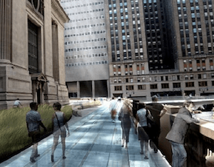
The attention-grabbing visual yesterday was SOM’s proposal to build a circular walkway above Grand Central, floating up and down between new skyscrapers on either side of the train terminal. In a panel discussion with the architects, New York magazine architecture critic Justin Davidson dismissed the concept as a “flying doughnut.”
The encouraging part of the panel was that aside from the flashy rendering, the architects are generally looking down, not up, to improve the public realm in Midtown East – and they urged the city to do the same as the rezoning moves ahead.
“The vibrancy of Manhattan is because there is so much action at the sidewalk level,” said Sir Norman Foster. “In exploring the fine print of the zoning, it should be sensitive to the activities at the ground plane, on the sidewalk.”
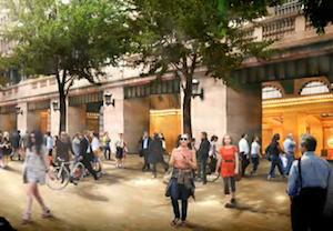
City Planning Commissioner Amanda Burden has already expressed interest in pedestrianizing Vanderbilt Avenue to accommodate the increased foot traffic that will accompany the completion of the East Side Access project. The architects followed Burden’s lead and went further, proposing to expand the pedestrian realm beyond Vanderbilt Avenue.
The ideas presented yesterday would convert Vanderbilt Avenue, and to a lesser extent 42nd Street, to pedestrian-priority zones. Foster's plan pays particular attention to pedestrian movement on the street and the already-crowded walkways and access points linking Grand Central, nearby sidewalks, and the subways. He noted that in Grand Central's nearly 100 years, the number of people moving through has increased ten-fold but the size of the terminal has remained essentially the same. To eliminate congested choke points and better connect the terminal’s interior to its subway corridors and surrounding streets, Foster proposed converting some of the current retail spaces into circulation areas, especially along the 42nd Street side of the terminal.
In plans from WXY and SOM, the Park Avenue viaduct, which wraps around Grand Central above street level, would become, at least in part, a space for pedestrians and bike riders. In its presentation, WXY drew direct inspiration from how the viaduct is used during Summer Streets.
All three architects warned that good intentions and a rezoning aren’t enough to create a high-quality public realm. Zoning is a blunt tool, noted Weisz. “There should be a public realm and transportation plan,” she said, to lay out a vision that can't be convey by a zoning text alone.
The Department of City Planning has indicated an interest in bold changes to the streets and public spaces around Grand Central, and three firms have laid out visions of what that might look like. As the rezoning progresses, we'll see if the city's plans live up to the potential.
