EXCLUSIVE: City to Launch Long-Overdue Traffic Study for Congested DUMBO
It’s the elephant in the room of poorly managed neighborhoods.
The city plans to launch a traffic study of DUMBO next year to investigate how the congested Brooklyn waterfront neighborhood could be safer for pedestrians and improve mobility, Streetsblog has learned.
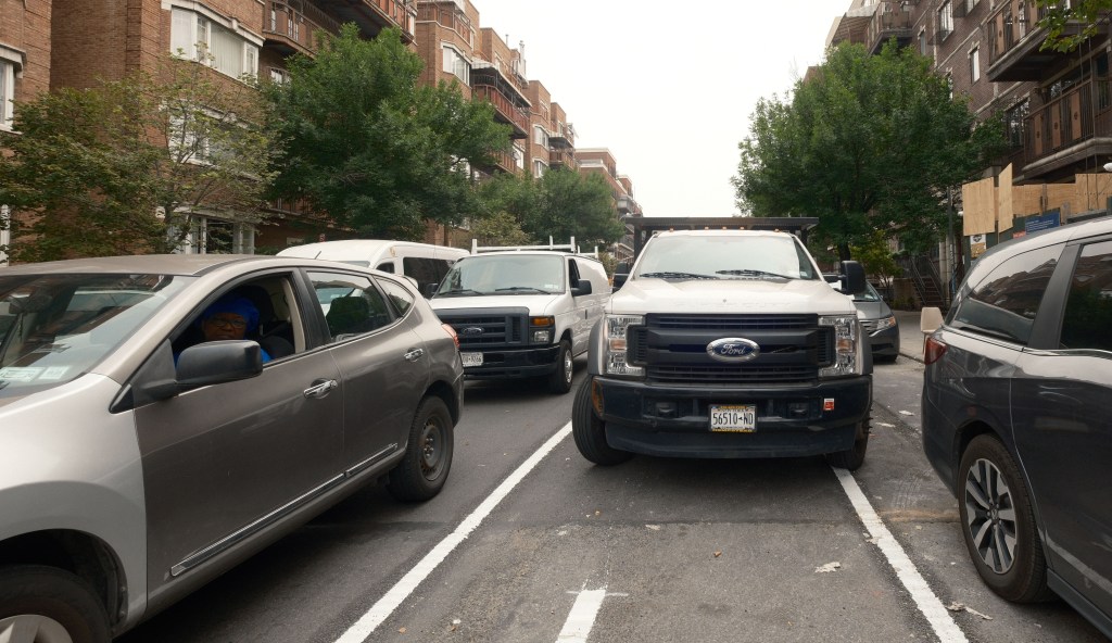
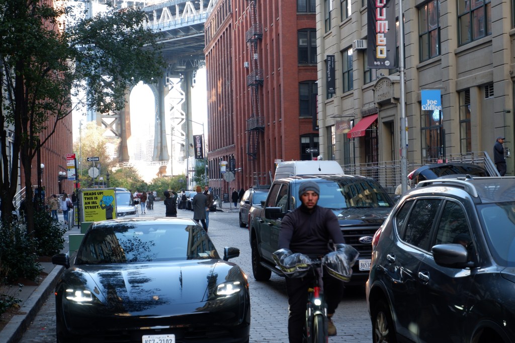
The roughly seven-by-four-block area between the Brooklyn Bridge and the Navy Yard is essentially a cul-de-sac and its narrow streets have become overwhelmed with congestion, causing safety issues and some of the slowest bus speeds in the city. The city will examine camera data, traffic recordings, and do walkthroughs, according to Council Member Lincoln Restler, whose district includes DUMBO and Vinegar Hill.
“It’s a neighborhood that has exploded in population with negligible planning,” Restler told Streetsblog. “It’s a moment for us to pause and think and plan how to move pedestrian and vehicular traffic much safer.”
While officials are still zeroing in on the details, locals have been beating the drum for a more organized streetscape for years. The survey is set to launch early next year, Restler said, and will cover the area on the map below:
DUMBO has transformed from an industrial zone into a thriving artist community that, eventually, gave way to a buzzing tourism hotspot and tech hub with a booming residential population — but a lack of city planning has left locals and visitors fending for scarce space.
The co-chair of the DUMBO Action Committee, a resident group that pushed for the study, said locals want to have a say in shaping the neighborhood.
“We just want more stop signs, more enforcement, and more thought put into what’s happening,” said Mallory Kasdan. “It’s just been kind of every man for himself down here. There’s tons of families that live here now. We just want to be safe walking around.”
DUMBO’s population grew by 66 percent in just 10 years — from 3,604 residents in 2010 to 5,975 in 2020, according to Census figures.
Meanwhile, car ownership more than doubled over the past decade and a half. There were 449 households with one vehicle between 2006-2019 and 951 in 2016-2020, according to the American Community Survey. The amount of households with two vehicles also went up during that time from 117 to 189. That math alone says there were 574 more cars in 2020 than there were in 2010.
Get ready for more, nearly 1,000 new parking spaces are slated to come online with just three new luxury residential developments.
The new 727-unit mega-complex Front and York will boast 660 parking spots. A high-rise right next to the Manhattan Bridge at 69 Adams St. will come with 225 apartments and 90 parking spots, while the nearby Olympia, a sail-shaped 76-unit tower at 30 Front St., will bring 220 parking spots online — enough room for nearly three cars per apartment.
The narrow streets of DUMBO were never made to handle these kinds of car volumes. The neighborhood sprang up during Brooklyn’s industrial heyday in the late 19th and early 20th centuries, when traffic was limited to horse-drawn carriages and cargo railroads rumbling down the Belgian block streets, some of whose tracks are still visible today.
DUMBO remained a relatively quiet place for decades after industries left and artists moved in. A sign of change came when the neighborhood got its first traffic light in 2010, because the Department of Transportation officials wanted to better regulate the increase in pedestrian and vehicle traffic of new residents and visitors flocking to the area.
The crowds and the gridlock have only gotten worse in the last decade, with the surge of new residents and thousands of tourists going down under the Manhattan Bridge overpass to catch views of former factory buildings, the city skyline, and stroll through Brooklyn Bridge Park.
Washington Street, where a rare view of the Empire State Building is framed in one of the archways of the Manhattan Bridge, is a particularly popular spot for shutterbugs. The clash of tourists and car drivers there is so bad that the local business improvement district put up signs … warning the tourists.
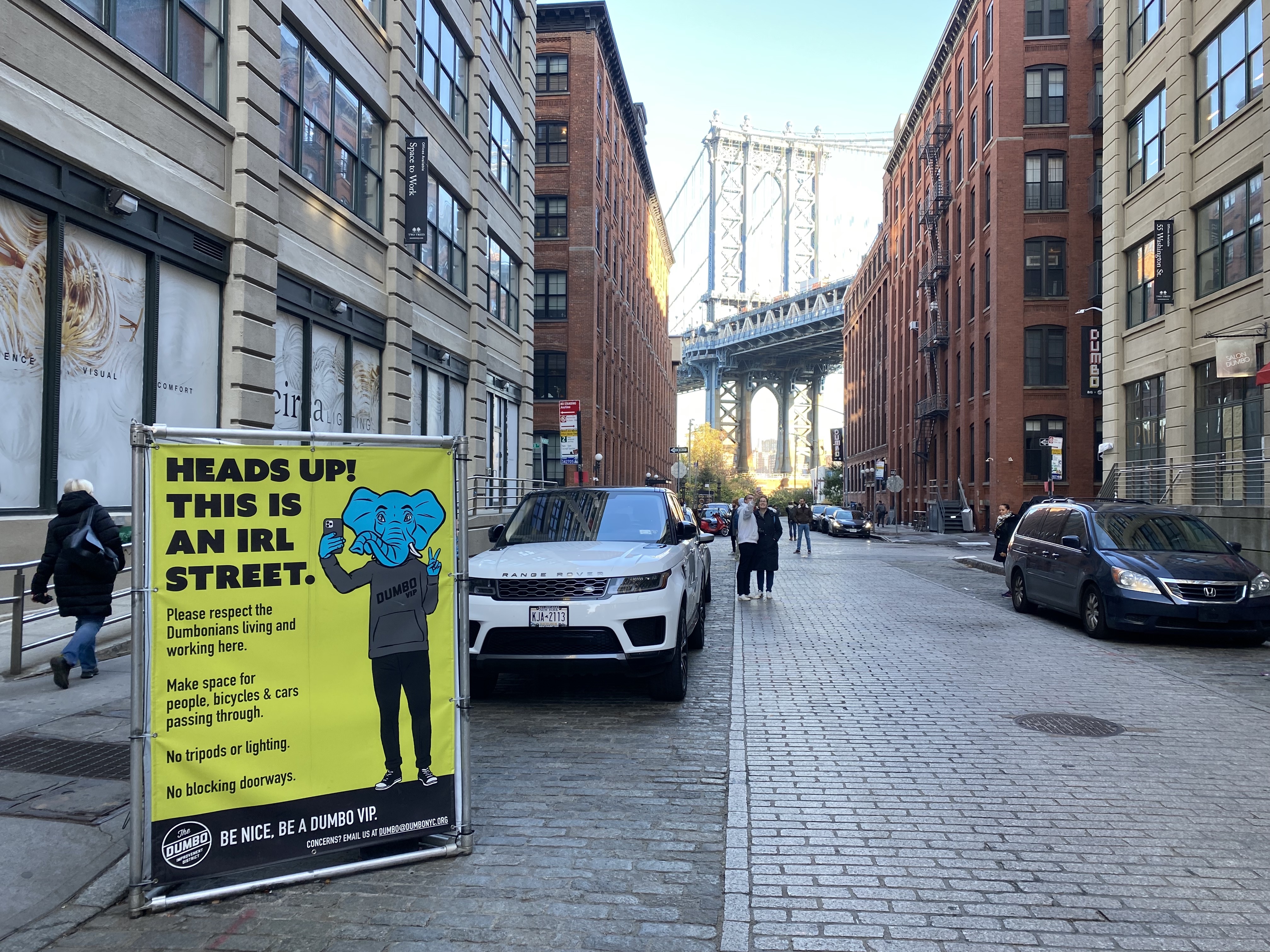
A handful of areas have been closed off to cars in recent years to better accommodate the foot traffic, such as the Pearl Street Triangle and the adjacent Archway of the Manhattan Bridge — home to the weekly Brooklyn Flea — and the Open Street on one block of Washington Street.
The traffic study will not consider a ban on cars in the neighborhood, but there have been some calls for such a move. After a New York Times columnist reported on the resurgence of tourism in the area, a few people responded by saying cars were the true culprit.
One journalist who lived in Downtown Brooklyn up until last month and used to drop his son off at pre-school in DUMBO said the city should be more ambitious and pedestrianize at least some of the neighborhood.
“Close off some of these streets — certainly the ones closest to the park and the water — just close all of that off, make it a giant pedestrian plaza. They did something like that in Times Square and people mostly love it,” said Marley Jay, a reporter at Business Insider. “You have people walking around and having a nice time and not watching traffic, and I think it’s pretty clear that most of this should just be for pedestrian use.”
Jay tweeted about his experience navigating the congested neighborhood back in August, shortly after the Times’ column came out.
“The city needs a lot more vision than it has, and one piece of that is making it a place where more people feel safe and can live comfortably, which means changing the way that driving and transportation work,” Jay said.
DUMBO’s transit infrastructure has also struggled to keep up.
The area’s main subway station at York Street on the F line only has one way in and out via a long and steep slope to the platforms, which locals have likened to a rock quarry. There next-nearest station at High Street on the A and C lines is closer to Brooklyn Heights on the far side of the Brooklyn-Queens Expressway.
Restler secured some $600,000 in funding for the traffic study from $7 million in proceeds that came out of a 2021 city air rights sale for the 69 Adams building.
That money was meant for upgrades at York Street and some of it already went toward a feasibility study of adding a second entrance to the station. The Metropolitan Transportation Authority claimed that would cost nearly half a billion dollars, because the station is deep underground and houses huge pillars holding up the Manhattan Bridge.
DOT will partner on the traffic study with the city’s quasi-public Economic Development Corporation, which oversaw the real estate deal at 69 Adams last year.
“We are excited about the possibilities to enhance pedestrian safety and improve mobility in the neighborhood and will have more to share at a later date,” said DOT spokeswoman Mona Bruno.

Read More:
Streetsblog has migrated to a new comment system. New commenters can register directly in the comments section of any article. Returning commenters: your previous comments and display name have been preserved, but you'll need to reclaim your account by clicking "Forgot your password?" on the sign-in form, entering your email, and following the verification link to set a new password — this is required because passwords could not be carried over during the migration. For questions, contact tips@streetsblog.org.