Eyes on the Street: DOT’s Meeker Ave. Bike Lane Plan Finally Attacks Parking (Well, Some of It)
It’s a great first step.
The Department of Transportation’s plan to tame Meeker Avenue in Williamsburg and Greenpoint [PDF] will remove scores of city-subsidized car-storage spaces under the Brooklyn-Queens Expressway and use some of the space for a narrow two-way protected bike lane and some minor pedestrian improvements along a key route between the Kosciuszko and Williamsburg bridge bike paths.
The long-awaited, much-delayed project started seven years ago as Transportation Alternatives’ “Make Meeker Move” campaign. Organizer Erwin Figueroa said the years of effort paid off in the form of a 25-0 vote of support from Community Board 1 and a promise from DOT that this the first part of an effort to improve safety on Meeker Avenue and make it a greater community resource.
Hundreds of parking spaces will remain — albeit metered for the first time — but the roadway on Meeker will not be altered, even in places where it’s wide enough to encourage speeding.
“The DOT framed this as a first step and they want to do more,” Figueroa said. “Over the years, the campaign shifted from safety only into also reactivating the space below the BQE, so repurposing half of that parking for pedestrian and walking is good for now. But the city needs to come back with a more concrete plan to address Meeker itself. Having pedestrian and cycling space below the highway is good, but vehicles still run red lights and speed.”
And having all those cars parked under the BQE eliminates many of the truly visionary possibilities put forward by TA in its epic “Meeker Avenue Reimagined” proposal in 2015. Check out this exciting slideshow (and mourn that none of this is part of the DOT’s current plan):
And the project only goes between the two bridges; TransAlt originally hoped it would continue all the way to the intersection of Flushing Avenue — another key part of the bike network to points west.
The project has been long overdue, but really became imperative once the Kosciuszko Bridge bike path opened in August, 2019. Hundreds of people use the new path every day (and the numbers are growing) and thousands use the Williamsburg path, according to the DOT. Cycling is also up in the area because of the expansion of Citi Bike into Greenpoint. Docks are expected to start showing up this year in East Williamsburg and just over the border in Maspeth, Queens.
Safety remains an issue: In the seven, pre-pandemic months that followed the opening of that path, there were 82 reported crashes, injuring two cyclists, four pedestrians and 13 motorists, up from an average in those same seven months of 76 crashes with 1.6 cyclists, 4.8 cyclists and 11 motorists in the five years before.
The mayor has often said that the future of the city is in fewer cars. If so, it’s worth asking if the Meeker project is revolutionary or merely evolutionary; after all, the design changes offer cyclists and pedestrians a few more crumbs compared to the access that drivers retain on this speedway-like strip.
Overall, the project will create an important link for cyclists who ride between Queens and Brooklyn or Lower Manhattan, and, hopefully, get cyclists off of both Driggs and Nassau avenues, which serve currently as the routes to and from the Kosciuszko Bridge bike path.
Nassau Avenue is a murderstrip westbound from Manhattan Avenue to the one-block protected bike lane just before cyclists access the safety of the bridge. Have a look:
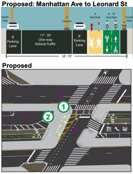
But the plan for a two-way protected bike lane on Meeker Avenue has a major flaw: at eight-feet wide, this two-way lane is four feet narrower than what the National Association of City Transportation Officials calls “desirable.” Eight feet is the influential group’s minimum for a two-way lane — and is certainly not going to be enough space, judging by the current traffic on other bike lanes on key routes.
Figueroa said cycling advocates complained about the narrow lane at the community board meeting earlier this month and were told by DOT that the lane will be eight feet in most parts of the project, but will grow to 10 feet in at least one area.
“The Brooklynites who spoke up at the community board session [earlier this month] are right — eight feet is not enough, especially given the amount of space available!” said Jon Orcutt, the spokesman for Bike New York and an area resident.
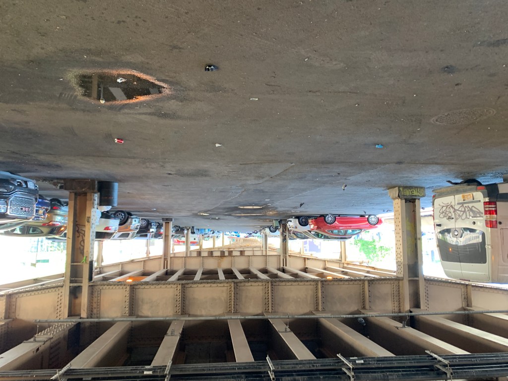
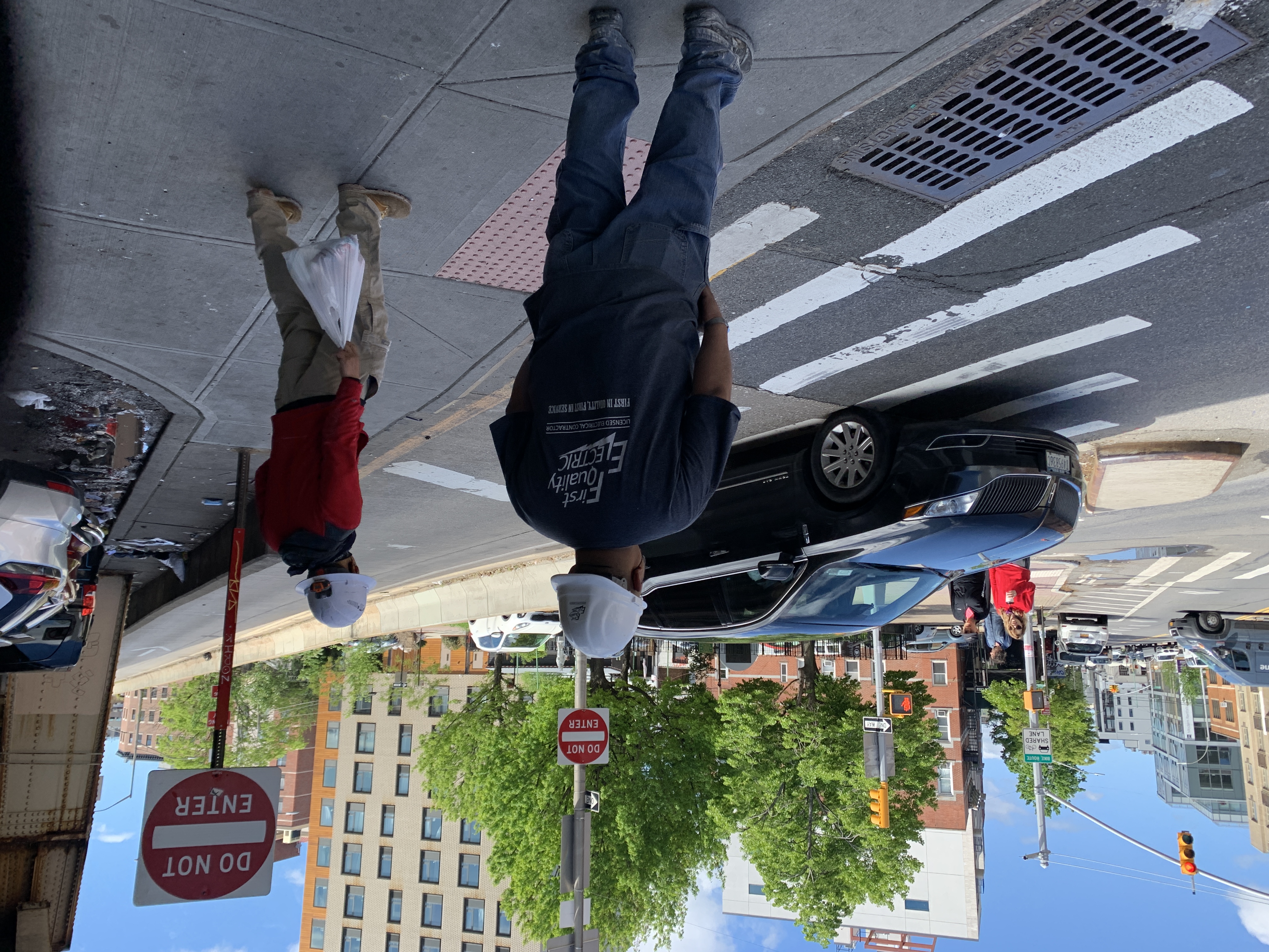
The proposal will also improve the experience for pedestrians, who currently complain of dark and filthy conditions under the Brooklyn-Queens Expressway, where currently the DOT has set aside roughly 660 spaces for free parking (Most of the cars left there never move, judging by the bird feces that collects on the hoods).
In the plan, the DOT says it will remove about 50 percent of the free spaces, and start charging $1.50 per hour between 7 a.m. and 10 p.m. for the remaining spaces, which will allow that parking to do what parking is supposed to do: support local businesses with turnover, not car storage. (The agency declined to comment on why it would not also charge car owners for overnight parking. The agency also declined to answer general questions on the or make Brooklyn Borough Commissioner Keith Bray available. Advocates for car drivers complained that the remaining spaces will be metered, eliminating a subsidy for drivers that drivers, as you might expect, don’t want to give up. It is unclear if the DOT is rethinking that plan.)
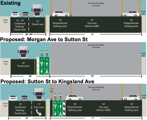
Let’s go over the plan block by block (heading east to west, as if you are biking from the bridge into Williamsburg:
Apollo Street to Morgan Avenue
Cyclists currently leave a protected sidewalk at Apollo Street and are plunged into a painted lane next to two lanes of speeding traffic until that painted lane ends at Driggs Avenue and becomes a sharrow, suggesting suggesting that cyclists could continue on Morgan Avenue if they wish to commit suicide.
Here’s what the area currently looks like:
The proposal calls for painted bike lane to continue all the way to Morgan and for curbside parking (a handful of spaces) to be eliminated. This is what that looks like, per the DOT:
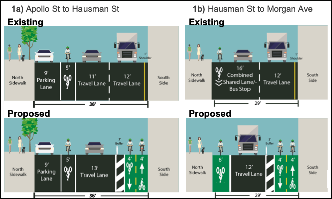
The agency said cyclists will get a special signal and the lights will be re-timed so they can get from the current bike lane on the north side of the street to the new protected bike lane on the south side of the street.
Morgan Avenue to Monitor Street
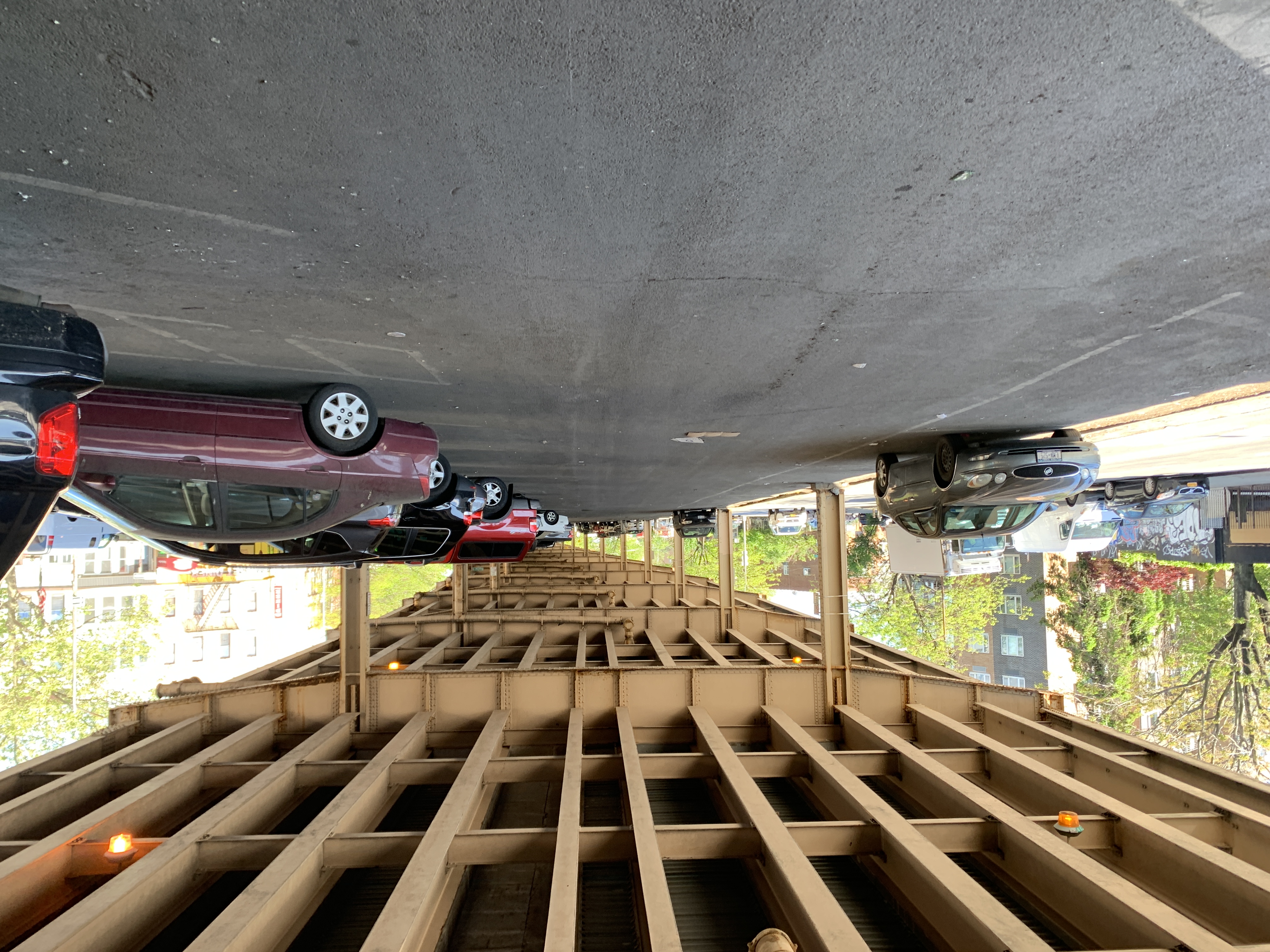
Between Morgan Avenue and Sutton Street, the BQE support structure on the left of the roadway opens up into a massive, filthy parking lot with space for roughly 103 cars in the parking zones west to Monitor Street, none of whose drivers pay a dime for the space currently, a massive subsidy that encourages car ownership.
Here’s what it looks like:
The DOT plan
The agency told Streetsblog that, again, cyclists would get a special signal and light timing so they can move to or from the path under the structure, and to avoid conflict with left-turning vehicles at Kingsland Avenue. When Streetsblog mentioned to DOT that car traffic backs up at the existing left turn at Kingsland, the agency said it was confident that this could be solved.
“We added more signal timing to help clear vehicles,” an agency spokesperson said in a statement. “Basically extending the green to pull the vehicle through after the red stops the vehicle making the turn.”
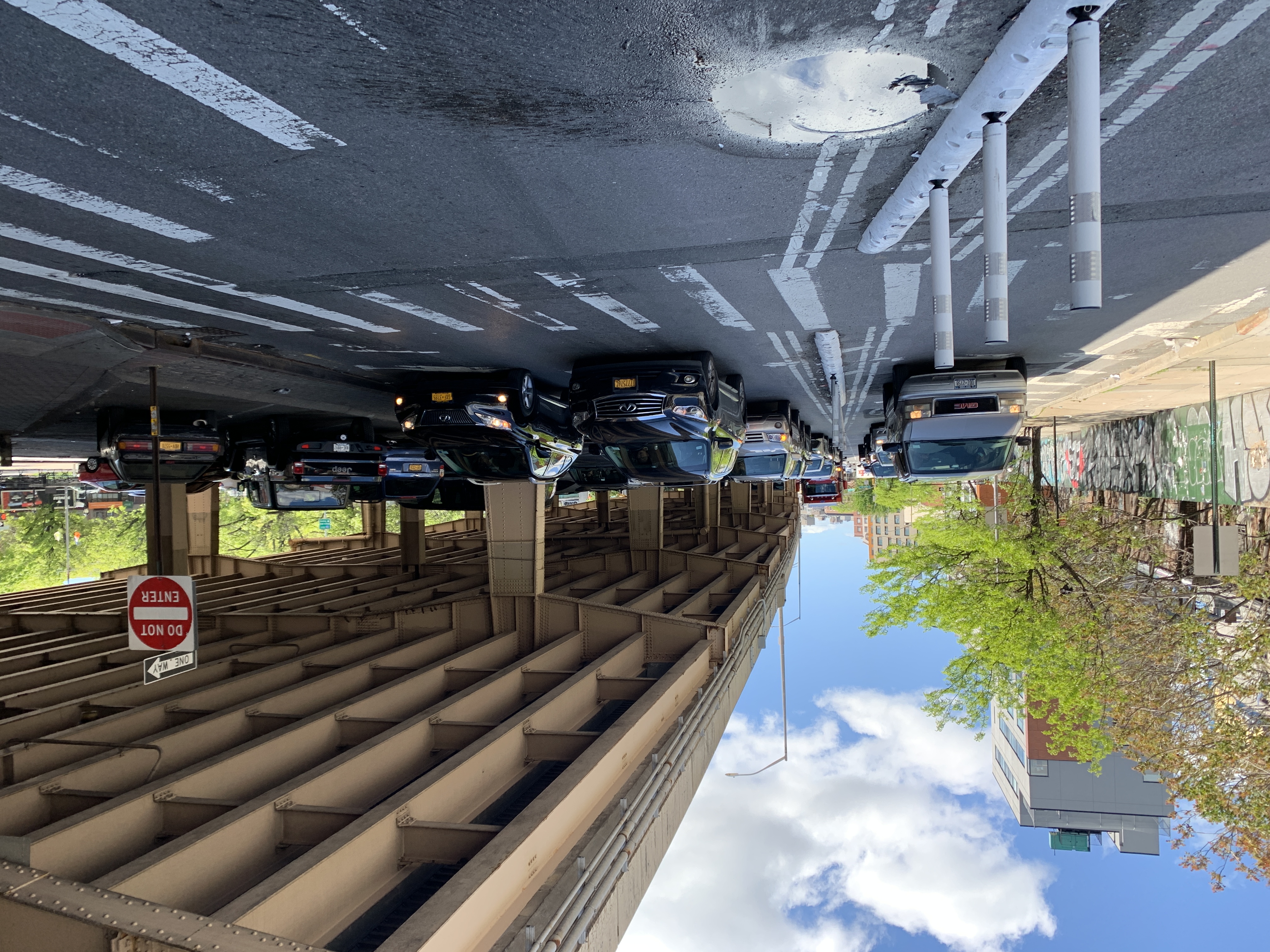
West of Kingsland Avenue, the roadway widens to three car lanes and a parking lane. There is also an uninviting sidewalk that is not smooth for strollers or wheelchair users.
Here’s what the area under the BQE looks like currently:
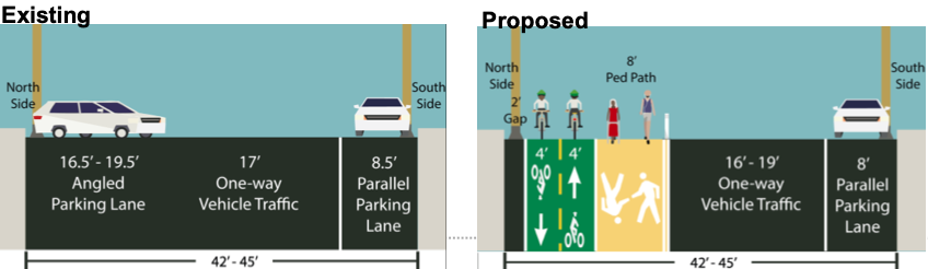
Monitor Street to Manhattan Avenue
In most of the stretch west to Manhattan Avenue, the roadway is three lanes plus parking. After Graham Avenue, the roadway narrows again to two lanes plus parking. There are roughly 185 parking spaces that currently occupy prime public space.
Overall, the area is a congested mess, thanks to auto repair shops that treat public space (both in the roadway and on the sidewalk) like their private parking lots. Here’s a slideshow of this area:
There is plenty of space under the BQE and in the roadway, however:
Along this stretch, the DOT proposes only to alter the parking zone for the two-way bike path and some additional space for pedestrians:
The intersection of McGuinness and Meeker is probably the worst in the neighborhood. On the eastbound side of Meeker, cars exiting the Brooklyn-Queens Expressway turn at high speeds onto northbound McGuinness Avenue at high speeds. The DOT believes it can calm the intersection with changes in signal timing and concrete curb extensions. See below:
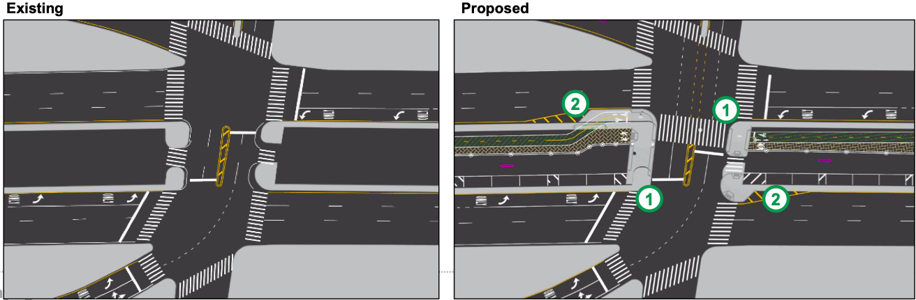
As you can see from the above graphic, the roadway opens back up to three lanes — and, yes, it is a speedway.
We would be remiss if we did not note the human aspect of this project, given that at least 10 homeless people live under the BQE in this area. It is unclear what the city will do for those people (the DOT did not respond).
Manhattan Avenue to Metropolitan Avenue
The last stretch of the city project does not seek to tame the speedway in part of this section (though the roadway finally narrows west of Lorimer Street). There are roughly 376 parking spaces in this area currently. An exit ramp off the BQE between Lorimer and Union (see below) requires the DOT to shift the bike lane (see below seeing below):
The two-way bike lane and wide pedestrian walkway remain under the highway, but because of that exit ramp, they both transition to the eastbound side of Meeker, still inside the parking area.
The DOT says it will use signal timing to get cyclists from the two-way bike path onto Metropolitan, where this is currently no safe bike infrastructure.
The DOT claims it will start this project sometime in the late summer or fall.

Read More:
Streetsblog has migrated to a new comment system. New commenters can register directly in the comments section of any article. Returning commenters: your previous comments and display name have been preserved, but you'll need to reclaim your account by clicking "Forgot your password?" on the sign-in form, entering your email, and following the verification link to set a new password — this is required because passwords could not be carried over during the migration. For questions, contact tips@streetsblog.org.