Rockaway Freeway, one of the few east-west routes across the Queens peninsula, isn't a safe place to walk or bike. A local coalition has been trying to change that by repurposing street space, but their efforts are running up against the red tape of city bureaucracy and a car-centric community board.
Rockaway Freeway runs beneath an elevated train. A road diet more than a decade ago narrowed the street to one lane in each direction, cutting down on crashes. But poor visibility around the concrete elevated structure is still a problem, and there isn't enough safe space to walk or bike. People are stuck using either narrow, crumbling sidewalks or striped areas in the roadway next to moving car traffic.
"This corridor wasn’t designed as a roadway. It was designed as an elevated railway," said Jeanne Dupont, executive director of the Rockaway Waterfront Alliance. In fact, some sections of the street have already been demapped, handing ownership from DOT to other city agencies or private developers.
"There’s sidewalk on the north side pretty much the whole length. On the south side, it is spotty," said Community Board 14 district manager Jonathan Gaska. "You do see people every now and then walking in the striped area, and the occasional cyclist."
Clearly the status quo is far from ideal, but the community board's idea of how to fix it would make it tougher to implement the walking and biking improvements that the Rockaway Waterfront Alliance envisions.
Gaska said the long-term plan is to widen Rockaway Beach Boulevard, which runs parallel to the elevated train and turns into Edgemere Avenue. Then, sections of Rockaway Freeway would be converted to parking. “During the summer, traffic is insane, especially going east and west... That’s a big concern here, and parking is a nightmare in the summer, especially on the weekends," he said. “Cars are very important for the residents here, and we keep that in mind.”
Dupont says parking is not the best long-term use for Rockaway Freeway, which could instead be repurposed for recreational uses or other public needs. The neighborhood should focus on adding options for walking, bicycling and transit, she said, instead of more parking, which will only bring more traffic.
Last Friday, Dupont presented an update on efforts to reimagine Rockaway Freeway to the CB 14 transportation committee [PDF]. She received a less-than-warm welcome, she said, and had to clear up some things with board members.
“There was concern that they would close the freeway, which we would not support in any way, shape or form," Gaska said. "And from what I heard from a committee member, that's not what they are considering. And that’s a good sign."
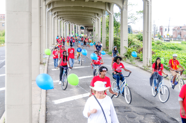
![A block party on Rockaway Freeway last month. Photo: Rockaway Waterfront Alliance [PDF]](https://lede-admin.nyc.streetsblog.org/wp-content/uploads/sites/48/2015/09/RWA-blockparty.png?w=710)
"I think there’s been a common misconception that we have a set plan or that we’re trying to remove cars from the underpass,” Dupont said. “That’s not the case at all. In fact, the past year has been a community engagement process and information gathering.”
After working with high school students last year on a video and petition for better walking and bicycling along Rockaway Freeway, RWA hosted bike rides, block parties, and bike education events on the street this summer. The group also began meeting with elected officials and city agencies, in addition to hosting seven workshops with local residents.
There has long been a racial and economic divide in the Rockaways. East of Beach 77th Street, 31 percent of households are car-free, according to 2013 Census five-year estimates. To the west, the car-free rate drops by more than half, to just 14 percent. RWA's own numbers show a divide: The group surveyed 188 residents near Rockaway Freeway. A majority identified as black or Latino, and said they frequently walk or bike along the freeway.
“When you look at that data, it’s very, very clear that this is not just about transportation. This is about social equity,” Dupont said. "This is a necessity for these folks. And the people who have the luxury of driving a car can say, ‘Oh, we don’t want you take that roadway away.'"
RWA has hired Sam Schwartz Engineering to produce concepts for how to repurpose space on the freeway. “There’s certain areas under the elevated track that have room for three lanes -- one walking, one biking, and one car,” she said. “There’s some really good temporary implementation that could be done that would not cost a lot of money and allow the community to try it out.”
Dupont said she met with DOT Commissioner Polly Trottenberg last week, who she said seemed interested in the idea. But getting DOT, other city agencies, and the MTA to row in the same direction is going to take a lot of work. Then, there's CB 14, which Dupont said skews to the wealthier, more car-dependent residents to the west. "There’s a long way to go with the community board," she said.
Update: DNAinfo's Katie Honan points out that CB 14 lists the zip codes of its members, which are roughly evenly distributed between east and west.
