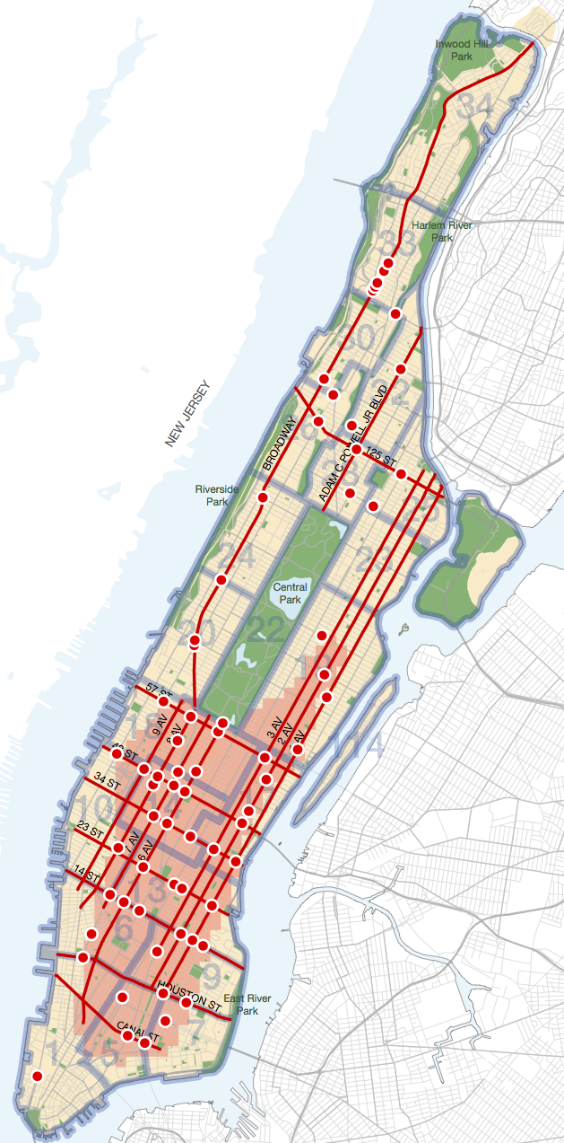
After unveiling its pedestrian safety action plan for Queens yesterday, DOT released plans for Manhattan and the Bronx today. (Staten Island will come tomorrow, followed by Brooklyn.) The reports each follow the same pattern, identifying problem areas in depth but describing solutions in general terms. It's clears from the sheer mileage of streets in need of safety improvements that the current pace of change is not nearly enough to achieve the city's Vision Zero goals.

"I feel like there is a lot of interest in the things we're doing, but we are at capacity right now in terms of the folks we need to go out to communities, to do the planning, to make sure that we're having a great dialogue with elected officials and with the public," Transportation Commissioner Polly Trottenberg said after today's press conference for the Manhattan plan. "We really have to think about being a bigger agency than we are right now."
Ultimately, Trottenberg deferred to City Hall, which she said has been "terrific on resources" for Vision Zero. "It's not up to me," she said. "It's a discussion with the administration about all the city's priorities."
Here are a few more takeaways from the reports on Manhattan [PDF] and the Bronx [PDF]:
Age matters. Seniors make up 14 percent of Manhattan's population but account for 41 percent of its pedestrian fatalities. In the Bronx, younger adults are particularly at risk: 18 percent of pedestrian deaths are people age 18 to 29, compared to just 10 percent citywide.
The challenge of speed cam placement under Albany's restrictions. In its borough pedestrian safety reports, DOT says it will locate speed enforcement cameras on streets identified as "priority corridors." That might be harder than it sounds: Albany regulations restrict speed cameras to streets that have school entrances within a quarter-mile -- and only during school hours. “In a lot of parts of the city, particularly in Manhattan, you’re most likely to see speeding at night. And that’s a challenge,” Trottenberg said. “We’re going to do our best."
Stepping up Manhattan's lax speeding enforcement. Patrol Borough Manhattan South Chief Salvatore Comodo said that his precincts increased speeding summonses more than 156 percent last year. Manhattan South, however, still issues far fewer speeding tickets than other parts of the city. Streetsblog asked if that's enough. "As far as the activity goes, we'll take a hard look at that," Comodo said. "We’ll focus our efforts in places where we think there are going to be violations, and we'll take it from there. There’s always room for improvement, and we’ll look to step that up this year.”
Studying bicyclists and motorcyclists: Of the 250 traffic fatalities citywide in 2014, 20 were bicyclists and 37 were motorcyclists. Trottenberg again promised to produce an update to the city's landmark multi-agency 2006 study of cyclist fatalities [PDF], and will be launching a similar investigation into the causes of New York City motorcyclist deaths. (Chief Comodo and Transportation Committee Chair Ydanis Rodriguez, when asked about preventing motorcyclist deaths, focused on ticketing illegal motorbike users, a consistent complaint of Upper Manhattan residents.)
![Map: NYC DOT [PDF]](https://lede-admin.nyc.streetsblog.org/wp-content/uploads/sites/48/2015/02/bronx_vz_map.jpg?w=710)
Can toll reform help Vision Zero? Truck drivers cause a quarter of Manhattan pedestrian fatalities, more than double the citywide share of 12 percent. Reforming the region's toll system would reduce the number of Manhattan-bound cars and keep trucks on highways instead of local Manhattan streets. Not coincidentally, DOT's pedestrian safety "priority areas" in Manhattan are almost entirely below 60th Street. "Clearly, there's no question when you look at our map, it shows you where the density and the congestion and the pedestrians are in Manhattan," Trottenberg said, adding that it's "too soon" to express an opinion about the connection between street safety and the Move NY toll reform plan, which was released yesterday.
Ultimately, the borough pedestrian safety reports will be a useful tool for communities that want DOT to make changes to improve street safety. “We really want people to have this information, to have this conversation," said DOT Assistant Commissioner Ryan Russo, "even if at times that’s a little bit uncomfortable for us.”


