The Tri-State Transportation Campaign's latest "Most Dangerous Roads for Walking" report [PDF] is another urgent reminder that roads and streets designed for maintaining auto capacity are not safe for people who travel outside a car.
Drawing on federal data from 2009 through 2011, the report ranks the region's most dangerous roads in terms of total pedestrian fatalities -- 1,242 in all during the three-year time frame. Reads the report:
Almost 60 percent of these fatalities occurred on arterial roadways, high-speed roads often with multiple lanes in each direction and few pedestrian amenities such as marked cross-walks or pedestrian count-down signals.
NYC streets with the most pedestrian deaths were as follows:
- The Bronx: Broadway (5); East Gun Hill Road (5); Grand Concourse (4); Baychester Avenue (4)
- Brooklyn: Ocean Parkway (6); Eastern Parkway (5); Kings Highway (4); Utica Avenue (4); Bedford Avenue (4)
- Manhattan: Broadway (12); Amsterdam Avenue (7); Seventh Avenue (5); Second Avenue (5); First Avenue (4)
- Queens: Woodhaven Boulevard (7); Jamaica Avenue (5); Union Turnpike (4); Queens Boulevard (4); Northern Boulevard (4); Lefferts Boulevard (4)
- Staten Island: Richmond Avenue (3); New Dorp Lane (2); Hylan Boulevard (2); Port Richmond Avenue (2)
Of Broadway's 17 pedestrian fatalities, only one occurred south of 96th Street. There was a concentration of fatal collisions in Washington Heights, where drivers head to and from the George Washington Bridge, and where Broadway's tree-lined medians and pedestrian islands disappear.
With 132, Brooklyn had the most pedestrian deaths of the five boroughs [PDF], followed by Queens (125); Manhattan (93); the Bronx (80); and Staten Island (21).
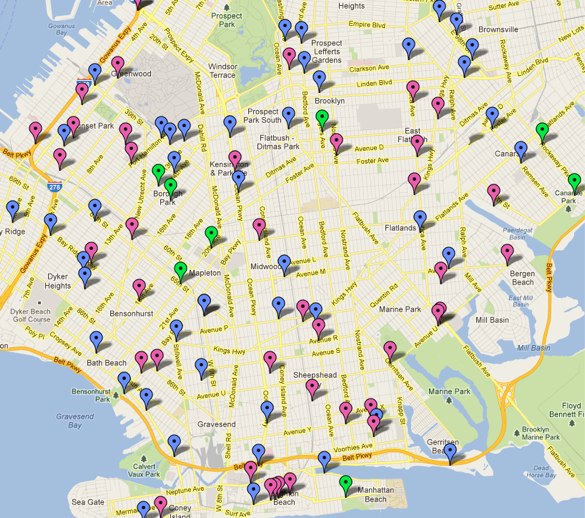
Tri-State mapped all pedestrian fatalities in each borough, including the gender and age of each victim. The maps suggest some disturbing patterns: note, for example, the number of seniors killed in southern Brooklyn and on the Upper East Side, and the spate of child deaths in East Harlem.
The report calls for more investment in pedestrian and cyclist infrastructure, and recommends speed cameras as a low-cost and effective way to reduce deaths and injuries.
