Brooklyn’s Bus Redesign Promises Fixes on 17 Notorious Bus Corridors

There’s now a road map to better bus service.
The proposed Brooklyn Bus redesign offered the usual mix of reconfigured routes to eliminate left turns and bottlenecks on narrow streets, new routes that reflect changes in employment patterns and more space between stops so bus drivers aren’t constantly pulling in and out of traffic.
But draft plan, which was released on Thursday, had a gem of a highlight: a map of 17 bus corridors with high ridership and crappy service that the MTA and Department of Transportation will team up to fix.
The 17 corridors are mostly found on the east side of the borough, where subway service is sparser, but many people get around without a car.
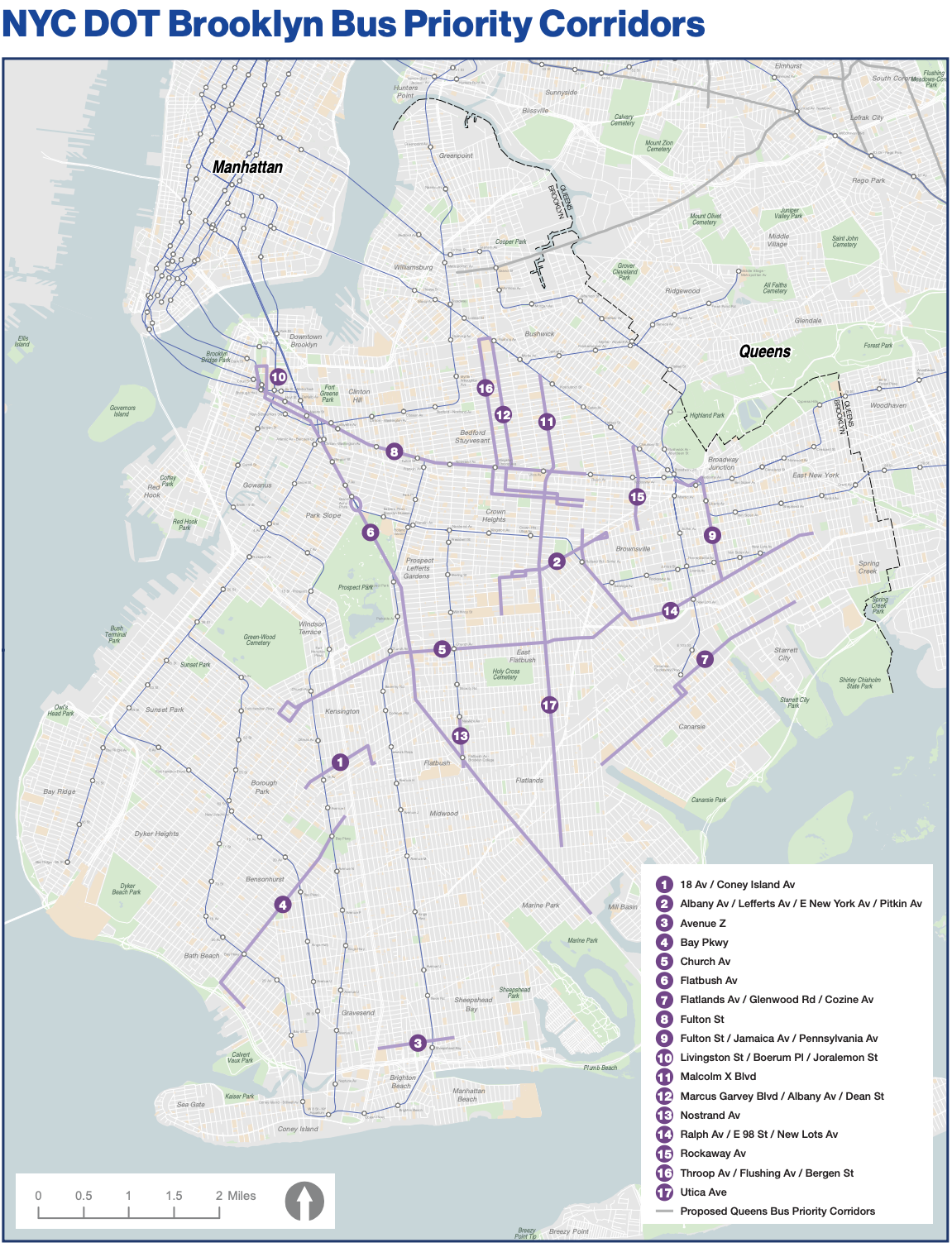
It’s too early to say exactly how the priority corridors will be redesigned — the toolbox includes dedicated bus lanes, car-free busways or merely transit signal priority — but the corridors in question need help: MTA officials said they were chosen because they are areas that need increased bus service, have high ridership and poor performance numbers, and play a crucial role in Brooklyn transit ecosystem.
Bus lanes and busways would also mean that the city could add more camera enforcement to the borough, which the MTA and DOT leadership identified as a key to getting traffic out of the way of Brooklyn buses, which average just 7 miles per hour across the sprawling and most populous borough.
“Working with the city, we’re going to be looking at bus lanes of course, and we’ve been rolling out automated bus lane enforcement, which is key,” said New York City Transit President Richard Davey. “Even if we have bus lanes, even if we have the best redesigns, if folks are violating the lanes or parking in bus stops is not helpful.”
Some work has already started on a pair of the corridors on the map. On Flatbush Avenue, the city and MTA have begun the outreach process for some unnamed bus improvement project or projects on the borough-spanning street, while on Livingston Street in Downtown Brooklyn, the draft report notes that the DOT is looking at idea that could include “physically separated bus lanes, bus boarding islands, and/or busways.”
The efforts to speed up buses on the corridors, such as the pieces of Flatbush Avenue where they currently move slower than 5 miles per hour, are more than just dreams. They’re also legally required under the city’s Street Master Plan, which mandates that the DOT build 150 miles of bus lanes by 2026.
Mayor Adams upped the ante to say he would build 150 miles of bus lanes over his first four years in office, though only 6.3 miles out of a promised 20 have been installed so far in 2022, according to Riders Alliance.
The bus redesign follows similar efforts in The Bronx and Queens. Brooklyn has 76 local routes (click for an interactive map) and more than 3.3 million people live within a quarter-mile of a stop (some lines extend into Queens).
There will be several upcoming opportunities to comment on the redesign. First, riders can fill out the comment form here. And there will be meetings in every one of Brooklyn’s 18 community boards between Jan. 11 and March 9. Click here to find the meeting near you.

Streetsblog has migrated to a new comment system. New commenters can register directly in the comments section of any article. Returning commenters: your previous comments and display name have been preserved, but you'll need to reclaim your account by clicking "Forgot your password?" on the sign-in form, entering your email, and following the verification link to set a new password — this is required because passwords could not be carried over during the migration. For questions, contact tips@streetsblog.org.