Carmageddon Likely from BQE Repair Work as DOT Will Detour Trucks into Residential Neighborhoods
The long-delayed prep work ahead of the even-longer-delayed rebuild of the crumbling Brooklyn-Queens Expressway will finally start in March — still nine months away — and will send hordes of cars and trucks through a large part of residential Brooklyn, the city announced last week.
Department of Transportation officials last Tuesday gave a Brooklyn Community Board 6 panel a basic rundown of the preliminary work that’s needed to shore up the beleaguered expressway before the city can tackle a full-fledged redesign of the six-lane highway — something former Mayor de Blasio punted to his successor.
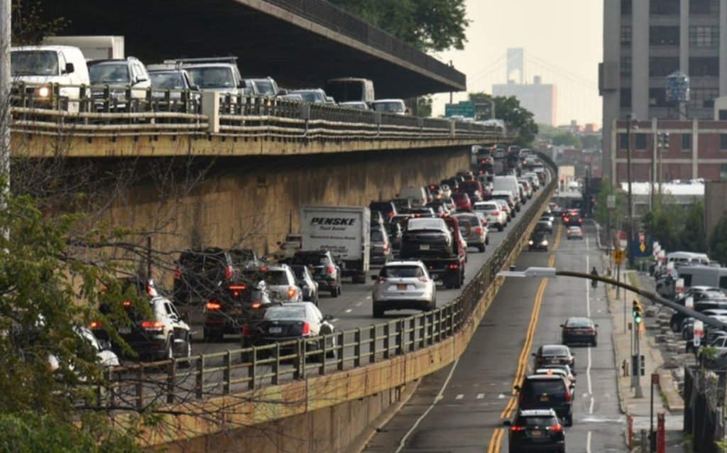
The work will mean closing sections of the BQE in each direction during an undisclosed number of nights and three weekends between March and October 2023, sending rerouted traffic — nearly 153,000 vehicles a day use the roadway — onto Third and Fourth Avenues and other local roads, which locals warn are already dangerous and deadly thoroughfares.
The first full weekend closure of all Queens-bound lanes between Atlantic Avenue and Sands Street will shunt all BQE traffic — which is significant on weekends, too — to the exit at Atlantic Avenue, a commercial street at the border of two densely populated residential neighborhoods with extremely narrow side streets.
The DOT wants traffic to detour onto Third Avenue via Washington and Atlantic avenues, Fourth Avenue via Flatbush Avenue, and down Furman Street. The northbound travel lane on Furman Street will in turn be closed between Atlantic Avenue and Old Fulton Street in order to open two southbound travel lanes, according to DOT.
When this work is being done, one of Staten Island-bound lanes between Tillary Street and Atlantic Avenue will remain open. And during the second and third weekends of the Queens-bound road work, all travel lanes in the Staten Island-bound direction will remain open.
The dates of all work remain to be determined, but the detours will begin on Saturday at 2 a.m. and end on Monday at 4 a.m., according to DOT.
One major eyebrow-raiser in the plan: When Queens-bound lanes are closed, freight traffic will be rerouted along Linden Boulevard after a circuitous detour from the highway’s Prospect Expressway exit around Prospect Park and to the east via Caton Avenue:
That truck detour will make an already bad situation worse. Last year on Caton Avenue and Linden Boulevard between the terminus of the Prospect Expressway and Kings Highway — a stretch of 2.8 miles — there were 257 reported crashes, injuring 139 people, city statistics show. Since 2014, there have been 3,610 reported crashes on that tiny stetch — an average of 380 per year — injuring 1,512 people and killing two pedestrians.
Officials could not share a more exact or detailed timeline for the work, but admit the nightly shutdowns and three weekend closures between March and October will cause some chaos.
“Our message to the world will be, ‘Stay out of here,’” said Tanvi Pandya, the DOT’s head engineer on the BQE project. “If you absolutely must, then use Third and Fourth avenues.”
Pandya says the city will strongly encourage alternative modes of transportation, but is also already planning for an onslaught of traffic on local roads by deploying Traffic Enforcement Agents and so-called pedestrian managers along the detour.
“We will have a heavy presence of TEAs to make sure traffic keeps moving…this is during summer months, when people are out and about,” she said. “We will encourage the public well in advance to avoid this area, and encourage them to use alternate routes.”
But locals say the effects of sending traffic down Third and Fourth Avenues, on top of the proliferation of distribution centers slated for Sunset Park and Red Hook, which will soon bring even more trucks to the neighborhood, will be disastrous for those already-deadly corridors.
“We have all these last-mile warehouses that are popping up — a lot more truck traffic is coming through this whole area. Are you aware of this because nobody seems to be, or at least not addressing it. I want this on the record that something’s got to be done,” said Madelaine Murphy, a public member of the board’s Transportation and Public Safety Committee.
The saga of the dilapidated structure that cuts through several neighborhoods, spewing fumes into communities, dates back to when Robert Moses first built it in the 1940s. But fast forward to 2018, when the city revealed that it was in danger of collapsing by 2026 under the weight of the 150,000 cars and 25,000 trucks that traverse it daily if it was not fixed.
The DOT then released two proposals for the entire section between Atlantic Avenue and Sands Street, including the triple cantilever, but both were dismissed as unpalatable to Brooklyn Heights and Cobble Hill residents. In the months following, a slew of other ideas were put forward — the two boldest of which were from the Regional Plan Association, which proposed nixing two lanes of traffic; and from then-Comptroller Scott Stringer, who called for banning all cars on the expressway, making it truck-only, and covering some portions with green space.
But instead of following any of those, the de Blasio administration created a so-called expert panel that was tasked with coming up with a new design to ensure, as the mayor said at the time, “We get this right.”
But by the end of this eight years in office, all de Blasio or his team could come up with was a patch-and-fix job to prevent the highway from immediate collapse, and punt a full re-imagination of the Robert Moses-era highway to the next mayor.
Mayor Adams said recently that he plans to at least move faster than his predecessor.
“I will not wait decades and needlessly spend hundreds of millions of additional taxpayer dollars when we can and must start rebuilding this vital transportation artery today,” Adams told the New York Times.
The previous administration had announced three specific measures to preserve the highway between Atlantic Avenue and Sands Street, including basic maintenance, better monitoring, and increased truck weight enforcement, the bulk of which still won’t start for another nine months.
Last summer, the city did make some progress by reducing the roadway from three lanes of traffic in each direction to two, along just half a mile from about Atlantic Avenue to the Brooklyn Bridge. The effects of that one minor change have already created unbearable traffic during all hours of the day along Columbia Street as trucks and drivers attempt to bypass the gridlock, said one area resident.
“It’s become a truck highway, I can’t open my windows. I know in my bones someone is going to die very soon because it is so bad,” said Bruce Mazer, who lives on Columbia Street near its exit from the Staten Island-bound BQE. “The DOT has really treated us like garbage. They’ve done absolutely nothing to ensure that people are safe here.”
But officials say that’s why the city — years after projections of the BQE’s not too distant collapse were first made — is focusing on a redesign of the whole corridor, from the Verrazzano Narrows Bridge in Brooklyn to the Grand Central Parkway in Queens, not just the 0.4-mile triple cantilevered-stretch under tony Brooklyn Heights.
“Essential point of this new BQE envisioning plan we really want to be thinking of the whole corridor it was a real priority of the mayor to think about equity not only from Atlantic to Sands but also the northern and southern end of the BQE, so really thinking about your lived experience and how to mitigate freight long term,” said DOT’s Julie Bero during the virtual board meeting.

Read More:

Streetsblog has migrated to a new comment system. New commenters can register directly in the comments section of any article. Returning commenters: your previous comments and display name have been preserved, but you'll need to reclaim your account by clicking "Forgot your password?" on the sign-in form, entering your email, and following the verification link to set a new password — this is required because passwords could not be carried over during the migration. For questions, contact tips@streetsblog.org.