SEE IT! Transportation Alternatives Shows Off ‘Shovel Ready’ NYC 25X25 Projects
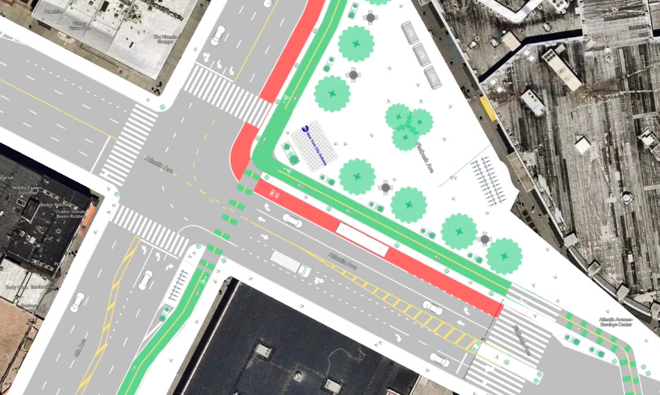
Imagine so much more space for people at Atlantic and Fourth avenues. Graphic: Transportation Alternatives
Transportation Alternatives has put the "five" in 25X25.
The safe streets group has released new videos to promote its "NYC25X25" proposal to repurpose 25 percent of space currently set aside for drivers— eye-catching animated designs that show off car-choked areas transformed into safe routes for cyclists, much better commutes for bus riders, and lots of new space for pedestrians to energize existing commercial areas.
"The redesigns in this project cover some of New York City’s most lethal and problematic streets and were created with a new, faster, more responsive process because to reduce car space 25 percent by 2025 we cannot go intersection by intersection," Transportation Alternatives Executive Director Danny Harris said in a statement co-written with Tiffany Chu, senior vice president of the shared transit company Via, a partner on the project. "This project demonstrates a new way to redesign streets by creating technical, actionable plans that incorporate globally-recognized best practices for street design and reflect specific input from the street users who best understand the need for change. We must radically rethink the infrastructure that shapes transportation."
Heretofore, the knock on TA's proposal is that it outlined a fairly big ask — the conversion of roadway space long monopolized by drivers into space for the city's non-driving majority — without drawing in actual projects beyond some initial sketches.
Well, that was then. Now, Transportation Alternatives offers five specific disaster zones that would change from dangerous and congested to neighborhood treasures. Here are the highlights (see TA's full report here):
Brooklyn
The hub of the borough — the Atlantic Avenue corridor around the Barclays Center — would be transformed from a car sewer (with multiple polluted feeder pipes) into the walking and biking core that it needs to be.
That means:
- At the tangled mess of Fourth Avenue, Flatbush Avenue and Atlantic Avenue, TA envisions the elimination of the block of Flatbush Avenue between Atlantic and Fourth avenues, which would be transformed into a much larger pedestrian zone connecting the LIRR's Atlantic Terminal and the useless triangle currently housing a former subway entrance (which, presumably, could be reopened). Northbound Fourth Avenue between Atlantic and Flatbush would be reopened to cars so to carry the traffic from the shuttered Flatbush Avenue, but the resulting area would include a dedicated bus lane and the continuation of the existing protected bike lane (which currently ends with no protecting in sight).
- On the eastern end of the area, a block of Underhill Avenue would be turned into a plaza to incorporate the orphaned Lowry Triangle, which no one uses because they can't get to it. Safe passage, and a basketball court, would make it more inviting.
- The wide median and turning lanes of Atlantic Avenue would be turned into a "bike superhighway." The elimination of many turns off of and onto Atlantic would have the side benefit of reducing driving through the residential neighborhoods on either side.
- Vanderbilt and Atlantic avenues — one of the worst intersections for cyclists, yet a widely used one because it is a key thru-route for riders — would get protected intersection infrastructure, thanks to the elimination of turns for drivers. "This could be the site of the city’s first fully protected intersection, separating cyclists from turning vehicles and reducing the probability of vehicle-bicycle crashes by 45 percent," the group said.
Here's what all that would look like:
The Bronx
The portion of Jerome Avenue in question would not be dramatically transformed, but key changes would happen on the side streets:
- Cromwell Avenue would be turned into a "school-bus only" roadway.
- E. 167th Street, where buses average 5 miles per hour, would become a car-free busway with a protected bike lane.
- And the southern end of Shakespeare Avenue would be turned into a plaza.
Check that out:
Queens
There are lots of pedestrians on Northern Boulevard, just east of Main Street in Flushing. This plan focuses on them and bus riders:
- The wasted median space on Northern would be turned into a public space with greenery, benches and tables.
- Northern Boulevard would also get a dedicated bus lane next to that nice new pedestrian space.
- Union Street would get dedicated bus lanes and protected bike lanes on both sides of the street.
Check it out:
Manhattan
Harlem's Main Street — 125th Street — is currently a heavily congested commercial district. But bus riders, especially, are discriminated against by the misallocation of space for, and the selfishness or delivery double-parking requirements of, a limited number of car drivers. The roadway is also a prime example of tree inequity, with street trees rarely surviving because of very small tree pits.
So Transportation Alternatives wants to:
- Add a two-way bike lane on the south side of the street.
- Move the existing dedicated bus lanes, which are often blocked by drivers, into the center of the roadway, with raised platforms for boarding.
- Pedestrians (and trees) would get a bit more space.
Here's what that would look like:
Incoming Council Member Kristin Richardson Jordan approves.
Staten Island
The pedestrian no-go zone bounded by Hylan Boulevard, Bedford Avenue, Mason Avenue and Lincoln Avenue — which contains IS 2, PS 38, Midland Field and Midland Playground — would be redesigned to encourage walkers rather than endanger them. The site in Midland Beach was chosen because of all the crashes: Midland Avenue had 101 reported injuries due to car crashes in the past five years, Lincoln Avenue had 81 injuries, and Hylan Boulevard (also known as Staten Island’s "Boulevard of Death") accounts for nearly one-third of SI’s traffic deaths since 2012 (though not all in this specific area).
That means:
- Mid-block on Midland Avenue, pedestrians would get a refuge and bump outs to ensure safe crossing between a park and a school.
- Other parts of Midland Avenue would be narrowed to slow down car drivers and to accommodate a protected bike lane.
- Lincoln Avenue would get a dedicated bus lane and lots of bump-outs for pedestrians.
In other words:
The fate of the NYC 25X25 plan is now in the hands of the future mayor, Eric Adams. In the past, he has signaled support for the concept of reclaiming space from car drivers and giving it back to pedestrians and cyclists. He has also long called for a "bike superhighway" in every borough, though he has typically said he seeks space under existing highways for them.
Stay in touch
Sign up for our free newsletter
More from Streetsblog New York City
Friday’s Headlines: Canal Street Follies Edition
Manhattan Borough President Mark Levine isn't happy. Plus other news.
Daylight Again: Bronx Community Board Backs Parking Ban at Intersections
The Boogie Down is down with daylighting!
Community Board Wants Protected Bike Lane on Empire Blvd.
Brooklyn Community Board 9 wants city to upgrade Empire Boulevard's frequently blocked bike lane, which serves as a gateway to Prospect Park.
The Brake: Why We Can’t End Violence on Transit With More Police
Are more cops the answer to violence against transit workers, or is it only driving societal tensions that make attacks more frequent?
Report: Road Violence Hits Record in First Quarter of 2024
Sixty people died in the first three months of the year, 50 percent more than the first quarter of 2018, which was the safest opening three months of any Vision Zero year.