SEE IT: Here’s What TransAlt’s ’25X25′ Looks Like (And What Kathryn Garcia Loves)
Welcome to 2025 — if you pick the right mayor, of course.
Transportation Alternatives has now made it possible to visualize its “NYC 25X25” plan to reclaim 25 percent of public roadway space from automobiles — and the resulting schematics already shook up the mayor’s race even before Friday’s release.
Surging candidate Kathryn Garcia announced late on Thursday that she would appear today at the epitome of car culture’s desecration of the city — Brooklyn’s hellish Third Avenue — to embrace TA’s plan. And that was apparently before she got a load of the pictures!
Garcia’s campaign said only that the former Sanitation Commissioner will “double down” on her commitment to implementing the advocacy group’s plan as mayor, but also that she will call for “more bicycle parking, particularly in low-income neighborhoods and neighborhoods of color — and [discuss] how she’ll actually execute on the mayor’s 11 deserted plans to improve bike security.”
(Garcia is not the only candidate to embrace the larger “25X25” vision. In March, Scott Stringer, Garcia, Maya Wiley and Shaun Donovan suggested they supported the plan, while Ray McGuire was less enthusiastic, Streetsblog reported. Since then, Transportation Alternatives told Streetsblog that Dianne Morales, Andrew Yang and Eric Adams have also signed on.)
TA imagines the city of the future no longer being “dangerous and congested” but “safe and efficient street.”
“A street that divides a neighborhood can become a place to connect,” the group added. “A street used for storing cars can instead become a place for communities to sit, meet, and gather.” Like these:
Residential street
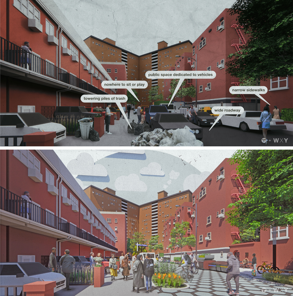
Residential streets, like the Queens streetscape above, are ripe for change: Thanks to wide roadbeds, drivers tend to speed. As a result, residential streets have the most fatalities per vehicle mile travelled, and a crash rate 2.7 times higher than highways, TA said. One in four children killed in crashes in New York City are killed within two blocks of his or her home.
Also alarming, residential streets — except for those who are lucky enough to live on an open street like 34th Avenue in Jackson Heights — are a mess: garbage is tossed onto too-narrow sidewalks, private cars are selfishly stored in the public roadway, kids can’t be kids.
The solution: get rid of parking, convert many roadways to slow zones, containerize the trash, and give kids a place to play and neighbors a chance to connect (again, like they do on 34th Avenue).
“Narrowing the street will reduce speeding and indicate to drivers coming off nearby arterials that this is a residential street,” TA argues. Also, creating room for more street trees is crucial: “One tree can remove the equivalent of 11,000 miles of car emissions from the atmosphere every year and reduce air temperatures by nine degrees on the hottest summer days,” the group added.
Other areas where this could be done include Commonwealth Avenue in the Bronx, Fourth Avenue in Bay Ridge Brooklyn, West 148th Street in Upper Manhattan and Laurel Avenue at Targee Street in Staten Island.
Arterial streets
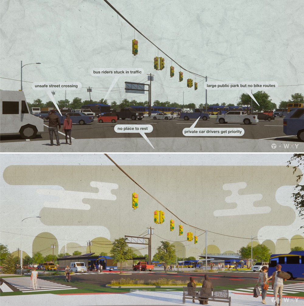
Speaking of our meanest streets, Transportation Alternatives chose a Staten Island-style arterial for its before-and-after reimagining. Such roadways comprise 15 percent of New York streets, but are the site of 60 percent of pedestrian fatalities. That’s mostly because of high speeds, but also because pedestrians are given no respect. And transit riders are treated even worse: instead of getting dedicated lanes for a conveyance that can transport 100 people in the space of four cars, the people on the bus are typically stuck behind those four selfish drivers.
So TA’s plan? Create far more dedicated bus-only lanes. And make roadways more inviting, which improves business for local shops. Also, there’ll be less pollution in the air.
Ideal locations for this kind of treatment? Boston Road in the Bronx, Flatbush Avenue in Brooklyn, Rockaway Boulevard in Queens and Canal Street (obvs!).
Commercial streets
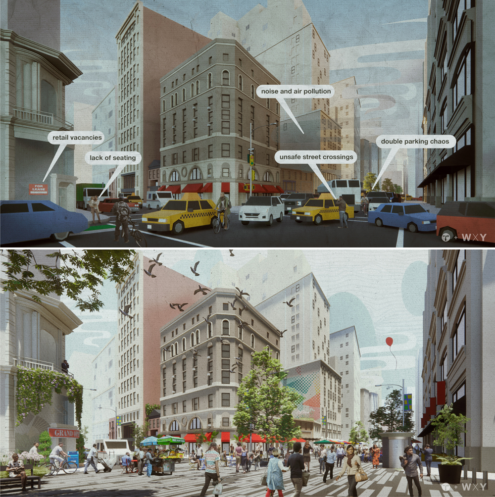
The issue with most of our commercial streets, according to TA, is “double parking and delivery chaos” that makes areas less-hospitable to the very commerce that these streets are supposed to support. No one wants to linger and shop on, say, Church Avenue in Brooklyn, or the scene depicted in the “before” shot above, from Manhattan’s Flatiron District.
“Pedestrians have been found to spend up to 65 percent more than drivers, [so] prioritizing foot traffic in commercial corridors should be a clear and obvious goal,” the group said.
The fix here is easy: Deprioritize the automobile with more bike parking, bike lanes, bus lanes and much much much more pedestrian space. The vast majority of shoppers on most New York City commercial streets are arriving by bus, foot, or subway — so why not cater to those shoppers rather than the tiny few who drive to one store and then leave (often paying nothing or below-market rates for their parking)?
On-street dining will also encourage shoppers to linger … and help the local economy.
Areas ripe for this kind of change? Third Avenue at Westchester Avenue in the Bronx, Austin Street in Queens, Willoughby Street in Brooklyn, and New Dorp Lane in Staten Island.
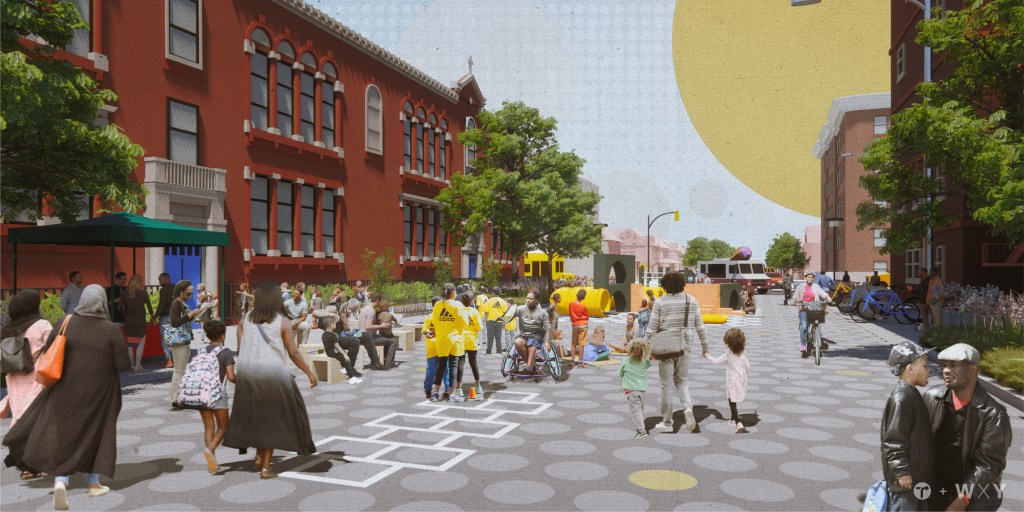
School streets
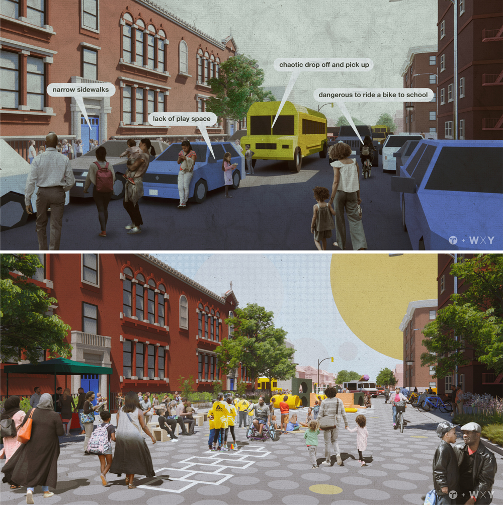
We’re told that nothing is more precious than our kids, yet the roadways around our schools are among the most dangerous for the most vulnerable. At the very least, there’s no way to let them walk or bike to school by themselves until they’re in high school and are about as independent as the residents of the former Soviet Union. [Full disclosure: This reporter sent two kids through a public elementary school that was less than 100 yards from his front door. And no, the kids were never allowed to walk there by themselves because doing so would require them to walk across Eighth Avenue in Park Slope — an unrepentant two-lane speedway that allows drivers to speed from the Prospect Expressway to Flatbush Avenue past a dozen schools, day-care centers, religious institutions and doctor’s offices.]
In the images above, replicating East 17th Street at Beverly Road at Brooklyn’s P.S. 245, TA advocates for a full closure of the street to car drivers, who will get some dedicated drop-off space around the corner.
“Shutting the majority of the streets outside schools to car traffic with permanent retractable bollards will calm local traffic, reduce traffic noise filtering into classrooms, make walking and biking to school safer, and allow for a safe and controlled drop-off and pick-up zones and the installation of bike parking,” TA said. “A full street closure to cars will also make room for a multipurpose educational and recreational space with active play spaces, teaching gardens, outdoor lunchrooms, and outdoor classrooms, as well as greening elements like bioswales, trees, and benches for waiting parents. It will also significantly reduce childrens’ exposure to air pollution and asthma incidence.”
You got a problem with that?
Streets ripe for this kind of treatment include Reservoir Avenue at West 195th Street in the Bronx, 35th Avenue at 35th Street in Queens, Tompkins Avenue at Vanderbilt Avenue in Staten Island and E. 100th Street at First Avenue in Manhattan.
Transit streets
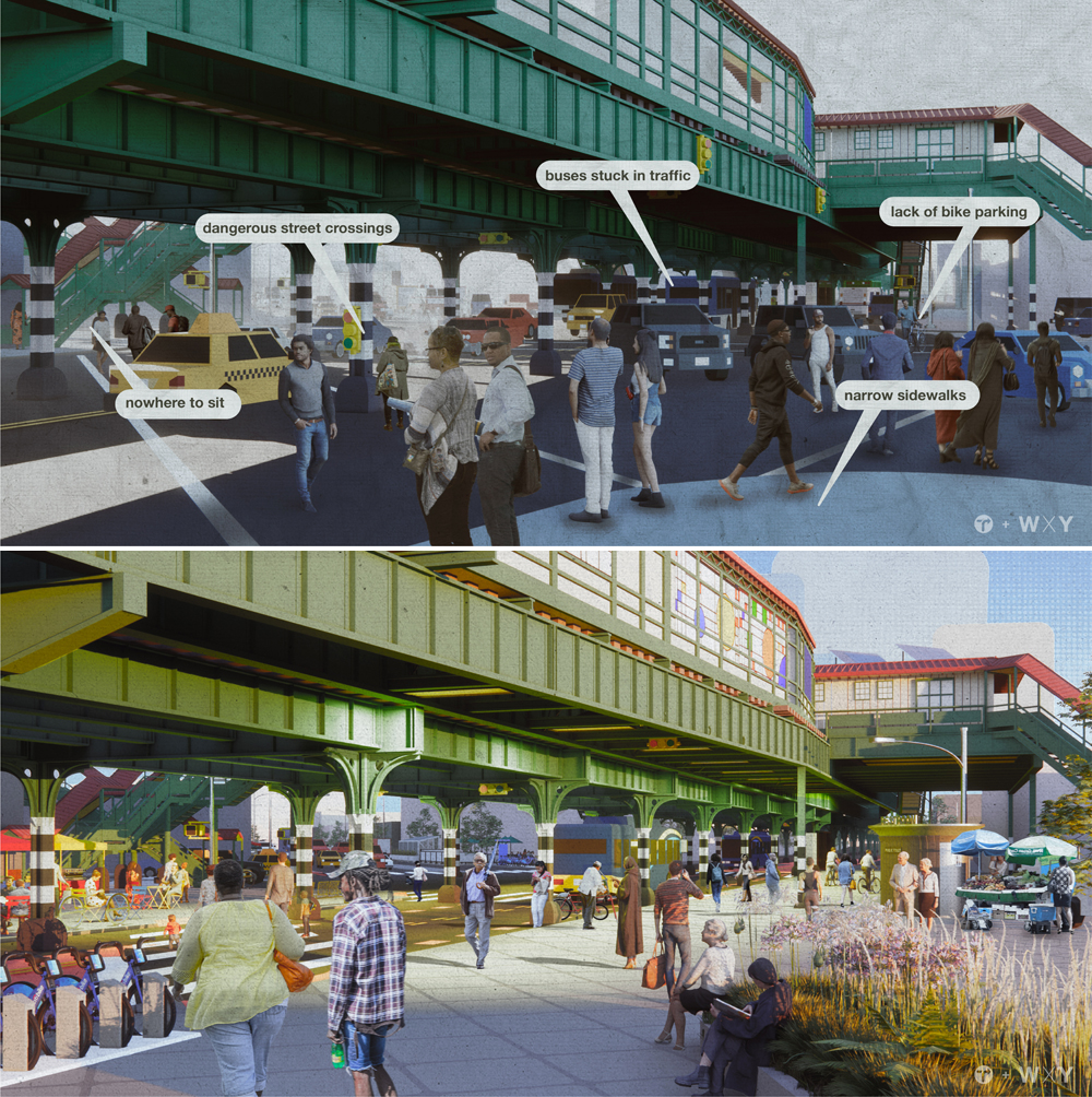
Much of New York’s transit system consists of elevated train tracks that block light; create dangerous conditions for drivers, pedestrians and cyclists; often are the site of multiple roadways and bus lines converging; and offer residents no reason to stick around while noisy trains travel overhead.
So TA advocates for roadway redesigns that prioritize the most users: bus riders and pedestrians.
The group’s image above is based on Westchester Avenue at Prospect Avenue in The Bronx — and it was chosen because 39 percent of Bronx transit users have to transfer to another bus (35 percent have to transfer to the subway) to get to their destination (far more than other boroughs), so transit streets should emphasize dedicated bus lanes and more space for comfortable, safe transfers to another bus or upstairs to the subway.
And why shouldn’t it look nice? It can also work under the elevated 7 train on Roosevelt Avenue in Queens, but also where there are underground lines, such as on Flatbush Avenue at Nostrand Avenue in Brooklyn, Times Square in Manhattan, and Richmond Terrace at Bay Street, Staten Island.
To read the full report, click here.

Streetsblog has migrated to a new comment system. New commenters can register directly in the comments section of any article. Returning commenters: your previous comments and display name have been preserved, but you'll need to reclaim your account by clicking "Forgot your password?" on the sign-in form, entering your email, and following the verification link to set a new password — this is required because passwords could not be carried over during the migration. For questions, contact tips@streetsblog.org.