What good is transit doing if it's not set up to get people out and about and walking? That's the question we're asking in the Parking Madness tournament this year as we look at transit stations surrounded by parking lots.
So far, parking craters in St. Louis, San Bernardino, Medford, and Poughkeepsie have advanced to the second round. Voting is still open in the Little Rock vs. Atlanta match.
Today, a terminal station in Norfolk, Virginia, goes up against a stadium complex in Queens.
Norfolk, Virginia
The Tide is a 7.4-mile light rail route that opened in 2011. The Tri-State Transportation Campaign's Joseph Cutrufo nominated this area at the end of the line:
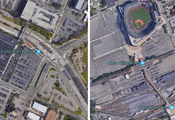
The western terminus of Norfolk, VA’s “The Tide” light rail line near the Eastern Virginia Medical Center is surrounded by mostly parking. Throw a stone in virtually any direction from the light rail platform and it’s going to land in a parking lot, a seven-level parking deck or a super-wide stroad. I wrote a little bit about that station area last year in this blog post.
In his post, Cutrufo notes that The Tide has the highest per-passenger subsidy of any rail line in the nation. This kind of land use may help explain why.
Queens -- Willets Point/Citi Field
What happens when you combine sports stadiums, some Robert Moses highways, a subway station and a commuter rail stop? You get this entry, which comes to us from reader Hugh Shepard:
New York City subway stations usually aren't surrounded by a ton of surface parking, but the area around Mets-Willets Point subway and Long Island Railroad station is a big exception. A huge parking lot for Citi Field, as well as the Willets Point Commuter parking lot, and other parking lots for the Corona Maintenance facility surround the station. As you can see, when there is no ballgame at Citi Field, or when the US Open is not going on, all of these parking lots sit empty.
Why this example is particularly bad is because of its amazing location. Housing is in a high demand in NYC, and the area is just a two-minute subway ride from Downtown Flushing, which is an extremely dense and busy Queens neighborhood. Also, the area is only a 26-minute subway ride from Midtown Manhattan. So clearly, demand would be there for walkable development of all sorts. The whole area is just a huge waste of space, and I can't believe that it hasn't been developed yet.
The voting is open until Monday at 2 p.m. Eastern Time.
