Once the MTA's East Side Access project is finally complete, a few additional upgrades will allow Metro-North's New Haven Line trains to stop at new stations in the East Bronx and cross the Hell Gate Bridge before heading to Penn Station. The Bronx is also expected to grow faster than any other borough in the coming years. With both factors in mind, the Department of City Planning has released a new report on the potential for transit-oriented development at Metro-North stations in the Bronx.

The study examines not only potential development but also how to improve access to train stations in neighborhoods divided by highways, rail lines, hills, and superblocks.
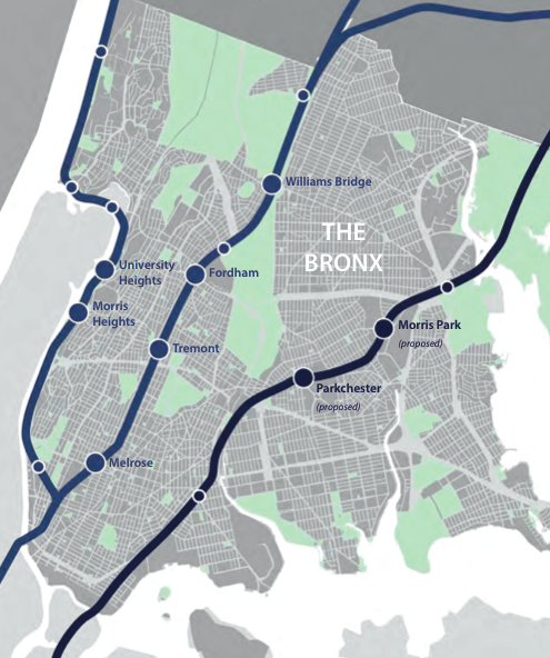
The plan focuses on eight Metro-North stations: University Heights and Morris Heights on the Hudson Line; Williams Bridge, Fordham, Tremont, and Melrose on the Harlem Line; and Morris Park and Parkchester/Van Nest on the proposed Hell Gate Line.
“The reason we chose these stations is because they had the greatest capacity for growth," DCP project manager Shawn Brede told the City Planning Commission during a presentation last week. The borough is projected to have the fastest growth rate in the city, with nearly 200,000 additional residents by 2040, a 14 percent increase over today.
DCP hopes to focus much of that growth in transit-accessible areas, and shifts already underway in the borough's commuting patterns show why Metro-North stations could be especially important. “The Bronx has the largest reverse commute [population] in the nation, and likely the fastest-growing," said Carol Samol, director of DCP's Bronx office. Nearly one in ten working Bronx residents commutes north of the city, according to Census data cited by DCP, and the highest concentration of jobs is along the New Haven Line.
While many Bronxites are commuting to suburban jobs, making it from Metro-North to work often isn't easy. "When people are going up to these job centers, they get off the train and they can’t make that last mile," Brede said at last week's presentation. Planners in Westchester and Connecticut are working on projects funded by the same federal planning grant from the Department of Housing and Urban Development to address these and other issues.
In addition to reverse commutes, the report looks at growing job centers within the Bronx that lack sufficient transit. The area around the proposed Metro-North station at Morris Park is a good example. “It doesn’t have a lot of transit access right now. The majority of people coming in are typically driving to this area," Brede said.
More than 16,000 workers are already commuting to jobs within a half-mile of the proposed Morris Park station, at complexes such as Hutchinson Metro Center, Bronx Psychiatric Center, Jacobi Medical Center, and Albert Einstein College of Medicine. That number is growing: A new 911 call center and Marriott hotel are under construction nearby.
Adding a new Metro-North station will help commuters, but that's not enough to get workers to use the train. For the area surrounding the station, the report recommends better sidewalks, a more connected street grid, and requiring first-floor uses like retail, which increase the appeal of walking. Changes could also include allowing denser development near the train station, where semi-industrial uses currently predominate.
DCP floated these ideas at community meetings near Morris Park before writing up the report. “We got a really good response to some additional density," Brede told commissioners.
The area around Fordham station doesn't need changes to jumpstart street life -- it's already one of the most vibrant retail hubs in the city. Here, DCP is seeking to reinforce efforts already underway to improve the public realm, and encouraged local organizations to take a closer look at parking management and marketing the area as a regional destination, among other recommendations.

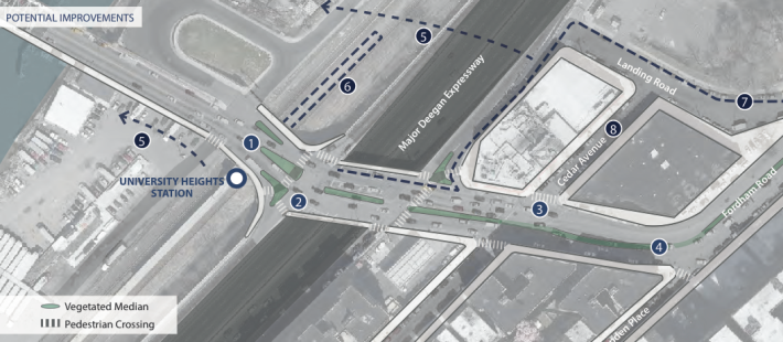
Not all Bronx Metro-North stations are so well used. The University Heights station, sandwiched between a sloping residential neighborhood, the Major Deegan Expressway, and the Harlem River, saw fewer than 250 riders on an average weekday in 2011. Like train ridership, a long-stalled waterfront development nearby has been stifled by limited access. Pedestrian safety is also a major concern: People trying to walk to the station must contend with heavy traffic coming to and from the Deegan.
“We’ve worked with DOT and we’ve identified some ways that minor improvements could happen: enhancing crossings, greening, channelization of the pedestrian and vehicular corridors," Brede said at the hearing. DOT told the commission that it is "still reviewing the recommendations."
The issue is on the minds of advocates. Last weekend, Transportation Alternatives hosted a "street scan" to identify hazards for pedestrians and cyclists using the Harlem River bridges, focusing on the University Heights Bridge. "The big issue is simply that there is too little space dedicated for pedestrians [and] cyclists," said TA organizer Tom DeVito. "The design clearly leads to avoidable conflicts between multi-ton vehicles and vulnerable street users."
City Planning Commission Chair Carl Weisbrod was intrigued by the plan. "The potential for these stations to enhance connectivity from one side of the tracks to the other," he said last week, "particularly in a borough, the Bronx, where the highway and parkway and expressway system has had the opposite impact in the past several decades, is I think a real opportunity here."


