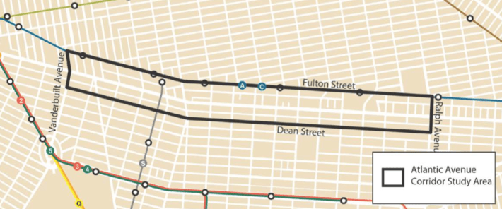
Atlantic Avenue is one of the most prominent streets in Brooklyn, but it's also one of the most dangerous. The major thoroughfare, paralleled by the LIRR and a subway line just two blocks away, remains a barrier between neighborhoods, plagued by speeding traffic and lined with auto body shops. Can it become an urban street that welcomes people instead of repelling them? The Department of City Planning is going to look at the possibilities along 2.4 miles of Atlantic Avenue.
DOT made Atlantic the first arterial slow zone in the city to receive a 25 mph speed limit, and volunteers with Transportation Alternatives have adopted it as one of their advocacy priorities. Borough President Eric Adams imagines a completely revamped Atlantic Avenue with new development and pedestrian-friendly streets. “In ten years' time we want to see a completely different Atlantic Avenue,” he told Streetsblog in April.
That effort is getting an assist from the Department of City Planning's transportation division, which launched a study of Atlantic between Vanderbilt Avenue and Ralph Avenue. While it doesn't cover the entire stretch to East New York and into Queens, these 2.4 miles includes key sections of Clinton Hill, Bedford-Stuyvesant, and Crown Heights.
DCP kicked off its work with a visit to Community Board 8's transportation committee last Tuesday. After giving a short presentation [PDF], planning staff divided attendees into groups. With large maps on each table, they asked residents to mark areas that could use improvement. DCP says it will eventually narrow its focus on specific intersections and recommend changes before wrapping the project next spring. Implementation and construction will be left to other agencies, including DOT.
Last month, CB 8 supported a DOT plan for Franklin Avenue that included a new turn restriction and expanded concrete pedestrian island at Atlantic Avenue. DOT says the new pedestrian space will be installed next year.
In 2012, CB 8 transportation committee co-chair Rob Witherwax drafted a memo to explore options for improving the area beneath the elevated LIRR viaduct [PDF], but it remains substantially the same today. "We need to devote some resources to ensuring that the north-south pedestrian movements across Atlantic are safe and efficient," Witherwax said in an email. "And we need to figure out ways to encourage economic development along the east-west axis that benefits the community."
This isn't the first time the planning department has planned a makeover for a car-centric arterial: The redesign of Queens Plaza, which included a two-way bike path and more pedestrian space on the approach to the Queensboro Bridge, began with a DCP study.
DCP will be holding more meetings on the project, but has not announced a schedule. In the meantime, volunteers with Transportation Alternatives will continue their advocacy along Atlantic Avenue. Previous efforts for a safer Atlantic have gained traction west of Flatbush Avenue. With the city's new study, advocates are shifting their focus to the rest of the street.
A couple weeks ago, volunteers walked the avenue in Crown Heights and Bed-Stuy to identify businesses and community organizations that could have a stake in a safer Atlantic. TA volunteers will be reaching out to local groups and conducting walking audits over the coming weeks to prepare for a community walk of Atlantic Avenue scheduled for August 16.
“We’re going to be in touch with [DCP] and giving them our feedback as we get it," said TA volunteer Michelle Chai, who lives near Atlantic. “I imagine we’ll have a good amount of information for them by the end of the summer.”
This piece has been updated to more correctly describe the event scheduled for August 16.
