Last night, Manhattan Community Board 2's transportation committee unanimously supported two safety measures: one to upgrade a bike lane on Hudson Street, and another to tweak pedestrian improvements at the car-clogged intersection of the Bowery and Delancey Street.
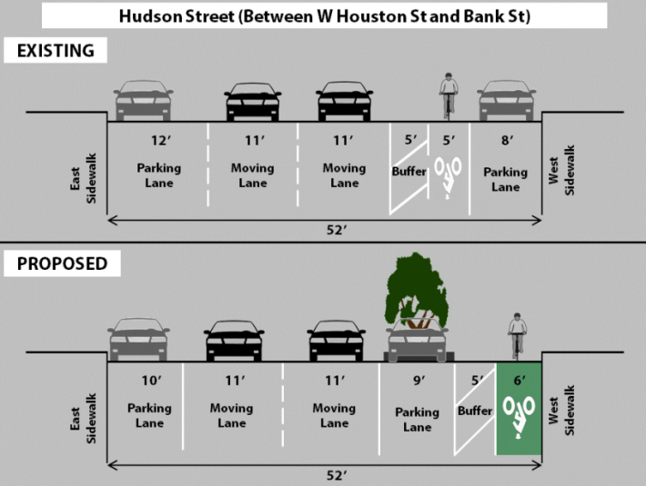
Almost two-and-a-half years after asking DOT to upgrade the faded buffered bike lane on Hudson Street to a parking-protected path with pedestrian islands, the committee unanimously endorsed a plan from DOT to do just that [PDF]. The next steps: support from the full board at its April 24 meeting, and construction beginning in July.
The plan actually extends two of Manhattan's most popular protected bike lanes southward. The Ninth Avenue protected lane will now reach a few blocks further south of 14th Street, on the southbound section Hudson Street, before joining the curbside striped bike lane on Bleecker Street. And on the northbound section of Hudson, cyclists will be able to use a protected bike lane starting at Houston Street before joining the existing Eighth Avenue protected lane.
CB 2's request in 2011 asked that the lane extend south to Canal Street, but DOT's plan stops at Houston. When the board made its request then, Hudson Square Connection BID executive director Ellen Baer said her members were split on the concept. While the BID has supported a number of other street safety improvements, it opposed the CB's request for Hudson Street. Since then, the BID has released a concept plan that includes a protected bike lane along Hudson Street, but asked DOT to leave it out of the plan the agency presented last night.
“So far, we’ve gotten very positive responses, but we continue to go out there and build support for the plan," Baer told Streetsblog. The BID's plan includes widening the sidewalk to create space for green stormwater infrastructure, a more significant design change than DOT is proposing north of Houston. “You want to do it all at once," she said. "You wouldn’t want to put a protected bike lane in this section and then come back.”
The BID has been working with DOT on its plan, and hopes to release designs in the coming months and begin construction as soon as 2016. I asked DOT bicycle program director Hayes Lord if he had spoken with the BID about using paint instead of concrete for pedestrian islands south of Houston, so the protected lane could be installed this summer while the BID finalizes a more permanent design. He said he did not, and that the BID and DOT decided last year to pursue the projects separately.
At Abingdon Square, where Hudson Street changes direction, the southbound lane transitions from a protected path to a buffered curbside lane as Hudson feeds into Bleecker Street. The project does not include the blocks north of 14th Street in Community Board 4, where the protected bike path on Ninth Avenue gives way to a painted curbside lane that loading trucks and left-turning vehicles regularly intrude upon.
The project involves a loss of 58 parking spaces, most of them to mixing zones and pedestrian islands. DOT said the plan would not affect more than three-quarters of the curbside spots on Hudson Street, and that the agency did not see a need to change curbside rules, but would be open to suggestions.
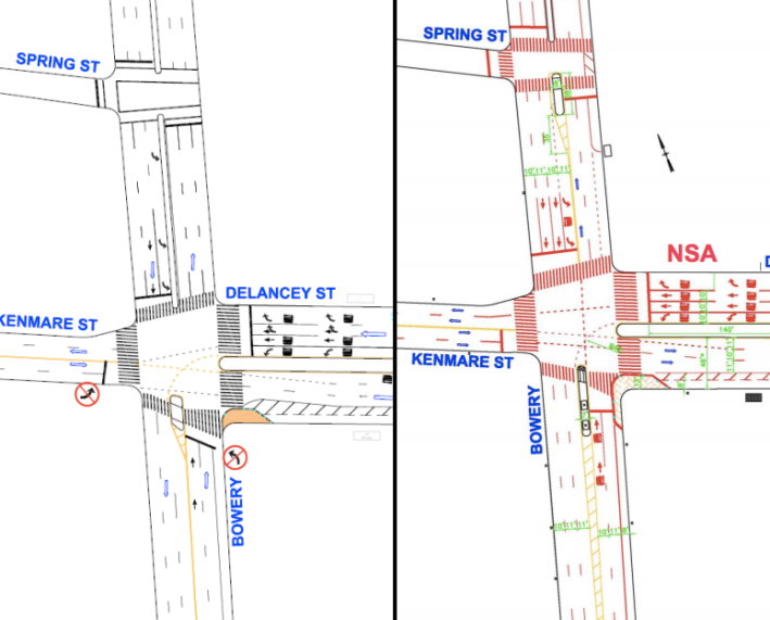
DOT also presented plans to adjust pedestrian safety improvements it made in 2008 at the intersection of Kenmare Street, Delancey Street, and the Bowery [PDF]. The plan shifts a pedestrian island on the south side of the intersection and adds an 11-second leading pedestrian interval for people crossing on the north side of the intersection.
DOT is making the adjustments because the 2008 changes have not resulted in the expected safety gains. “The problem with this intersection is the volume," said Sean Quinn of DOT's pedestrian projects group. He explained that the crush of cars has effectively wiped out any safety boosts DOT was aiming for. “It didn’t get worse, it just didn’t get better," he said.
Quinn was focused on the high volume of drivers going southbound on the Bowery and turning left onto Delancey Street. Backups there mean drivers feel pressure to clear the intersection quickly, leading to what Quinn called "rash decisions."
To accommodate these drivers, DOT is proposing to eliminate a small concrete median on the north side of the intersection to create another southbound car lane. The plan also adds a larger pedestrian island on the Bowery at the south side of its intersection with Spring Street. CB 2 transportation committee vice-chair Maury Schott suggested DOT look into extending the left-turn lane north of Spring Street as well. Quinn said he would look into the idea, with the goal of keeping the new pedestrian island at Spring Street.
The plan has already received support from CB 3, which borders the area. After receiving a go-ahead from CB 2, Quinn said he hopes the project can begin construction in May.
George Haikalis, a longtime regional planner and public member of CB 2's transportation committee, noted that the high car volumes at this intersection are the result of a dysfunctional regional tolling system that provides an incentive to use the free Williamsburg Bridge to cross Manhattan. At the end of the meeting, he joked that to take cars off surface streets, maybe the Lower Manhattan Expressway should have been built, after all.
