Last night, the transportation committee of Brooklyn Community Board 6 voted unanimously in favor of a new PARK Smart zone for Atlantic Avenue, Smith Street, and Court Street, and for a Brooklyn Waterfront Greenway segment connecting Van Brunt Street to Valentino Pier in Red Hook.
The new PARK Smart zone, which Stephen covered earlier this week, works differently than PARK Smart in Greenwich Village and Park Slope, where on-street parking rates rise when demand is highest. NYC DOT's proposal for Cobble Hill and Boerum Hill is to have rates rise progressively after the first half hour. The goal is to reduce traffic by discouraging long-term parking and all-day meter feeding in curbside spaces that should be turning over frequently. Brooklyn CB 2's transportation committee voted for the plan on Tuesday.
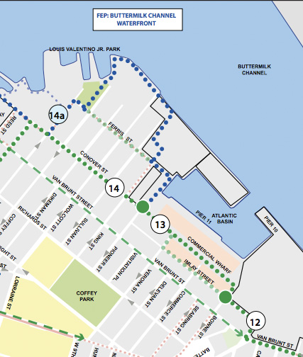
DOT also presented plans for a Brooklyn Waterfront Greenway segment that would loop out to Valentino Pier from Van Brunt Street. We have a request in with DOT for last night's presentation (Update: Here it is), but in the meantime, below is a map of this part of the greenway from DOT's implementation plan [PDF]. It looks like the segment that the CB 6 committee voted for last night includes capital projects 12, 13, and 14 (not 14a), or parts thereof:
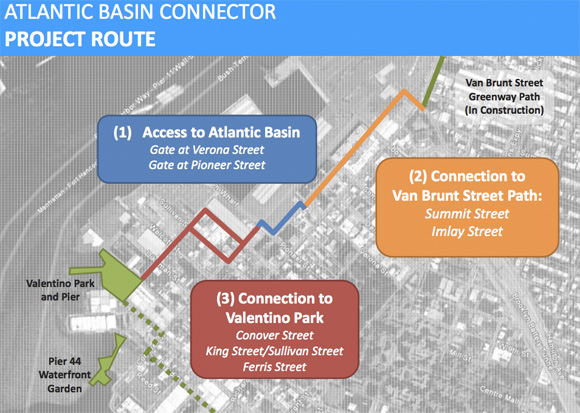
Update: The route DOT presented last night makes use of Imlay Street and not the "commercial wharf" blocks in the above map. Here's the proposed route map:
Committee member Eric McClure sends in this recap of the presentation:
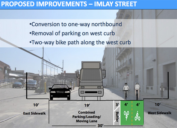
The proposal is to extend the two-way Greenway bike route from Van Brunt & Summit westward along Summit, then southward along Imlay just past Verona, where it will bend to the west through a new entrance into the large Atlantic Basin bus parking lot, turn south immediately against the eastern fence of the lot, west again following the interior contour of the lot and then exit onto Conover through another new entrance. It will continue south on Conover (which will be converted to one-way northbound for the portion containing the Greenway) and then westbound to Ferris, where it will turn south to the park entrance at Coffey. It will return via Coffey to Conover. The Dikeman and Coffey portions will have sharrows, and the Ferris portion will just be a signed route. Traffic volumes are tiny on Ferris, Dikeman and Coffey.
The plan for Van Brunt is simply to put down stencils, since it's too narrow to accommodate anything more without being reconfigured to remove parking or make it one-way.
