Traffic crash data, long a closely guarded secret of the NYPD, is now slowly being released online.
Pursuant to the Saving Lives Through Better Information Act, which took effect Wednesday, the department will begin posting monthly updates on summonses and crashes, differentiated by mode of travel and contributing factors and broken down by precinct and borough. Eventually, crash data will also be mapped.
The first data dump is limited to summonses, issued in May and in the year to date. At first look it appears that NYPD is concentrating on cell phones and seat belts -- with 81,639 and roughly 82,000 summonses, respectively, handed out this year. Meanwhile, only 36,660 drivers have been ticketed for speeding citywide as of the end of May, and the vast majority of them were cited by the Transportation Bureau, which includes NYPD Highway Patrol. When you drill down to the neighborhood-level data on local streets, speeding enforcement is almost non-existent.
In Manhattan's 34th Precinct, where I live, no speeding tickets were issued in May. The number of drivers cited for speeding so far in my precinct in 2011? Seven, or about as many as can be observed whipping down a neighborhood block every minute or two on any given day.
The value of this information can hardly be overstated, and we wouldn't have it without Transportation Alternatives and Jessica Lappin, who shepherded this bill through City Council. There's a reason advocates have for years pushed to make crash data available to the public. Says TA: "Formerly, traffic's chaos was anecdotal; vocal citizens storytelling too many crashes and nary a summons in response. Now the NYPD is required to publish exactly what they do to curb dangerous traffic. New York City is a safer place than it was 20 years ago because of NYPD crime data: analyzed, transparent, published. Now, with traffic data published too, TA expects equivalent reduction in traffic's danger."
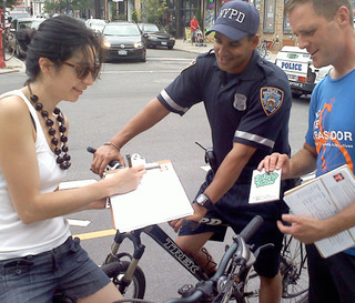
Another positive development is the collaboration between TA and NYPD to use traffic data to promote safety. Officers from the 94th Precinct in Brooklyn joined TA Wednesday in handing out flyers to pedestrians, cyclists, and drivers at North 6th Street and Kent Avenue, an intersection revealed by traffic stats to be particularly dangerous. TA will also be coordinating with neighborhood advocates to discuss data at precinct community council meetings this summer.


