Last week's MTA fare hikes marked the latest setback in a string of bad news for New York City transit riders. But with the launch of Select Bus Service on the East Side of Manhattan this week, some advocates are looking ahead to further opportunities to enhance the city's surface transit network. The Pratt Center for Community Development just released its Transportation Equity Atlas, a set of maps detailing the critical need for more transit options, particularly in New York City's low- and moderate-income neighborhoods.
Overall, Pratt shows that New York City's transportation system doesn't serve low-income residents nearly as well as it should. 750,000 New Yorkers have a commute longer than an hour each way, for example, and two-thirds of them earn less than $35,000 a year. Only six percent of those long commutes are made by those earning over $75,000 a year.
There's a racial divide, too. Black New Yorkers, on average, have trips to work that take 25 percent longer than white New Yorkers. Hispanic New Yorkers' commutes take 12 percent longer than white New Yorkers' commutes.
"If you work in a service or a manual job, you're more likely to work in a place that is also not well-served by transit," explained Pratt's Joan Byron. "I think there hasn't been much of a focus in transportation planning around blue collar and service job clusters in New York City."
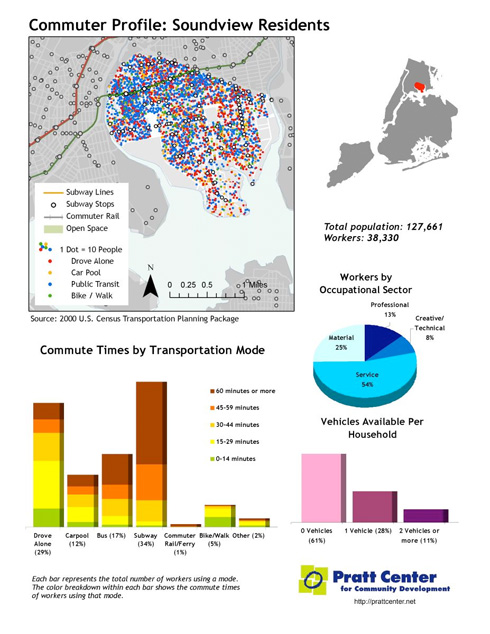
Pratt breaks down their information -- drawn from the 2000 Census -- to look at particular neighborhoods and job centers. In the Bronx, for example, most Soundview residents live outside walking distance of the subway. It's no surprise, therefore, that even though only 39 percent of households own a car, 41 percent of households drive or carpool to work. Without a decent transit option, many residents in this low-income neighborhood are forced to take on the huge financial burden of car-ownership and suffer lengthy commutes:

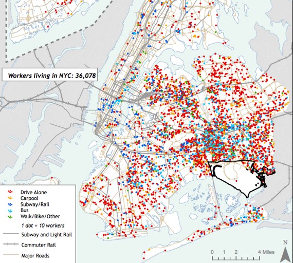
JFK Airport is one of the region's largest job centers, with 55,000 workers. But because of limited transit access to Southeast Queens, especially in the off-peak hours that many airport workers travel, most of those workers drive there. (The Airtrain, which opened after this data was collected, likely changed the numbers to some extent.) Better transit access to this economic engine could take thousands of cars off the road (especially the congested Van Wyck) and save working New Yorkers thousands of dollars a year.
Pratt has put together similar profiles for a total of 13 communities and 10 job centers and it's well worth exploring all of them. Byron noted that connecting workers with a huge job cluster like Central Brooklyn's hospital complex would be a top priority in a city like Cleveland, but that "because New York is such a huge job market, this isn't even on the radar here."
So how to fill in these major gaps in the transit system in a time of fiscal austerity? Pratt recommends building out a major new BRT network as the most cost-efficient way to bring transit to all New Yorkers quickly. They envision a network of 16 BRT routes, which would cross borough lines in a way that current Select Bus Service plans do not. Their map not only would connect lower-income neighborhoods to Manhattan but also to job centers in the other boroughs. One line, for example, would run from Washington Heights through Soundview to JFK.
Byron hopes that the data presented in the Transportation Equity Atlas inform the NYC DOT and MTA as they continue to plan the second phase of their BRT plan. "If you're going to do more than a pilot, you need to think about where are the people it could benefit the most, where are the difficult trips," explained Byron. She said that approach already appears more in evidence in phase two than in the first Select Bus Service routes.
Recently, transportation advocates have been forced to mostly play defense. When it comes time to plan for better service again, however, advocates and officials alike will now be able to do it with the Transportation Equity Atlas open in front of them, reminding them that the transit system still doesn't work for many New Yorkers.


