Brooklyn commuters -- already some of the biggest transit riders in the country -- are opting for transit at ever higher rates. New numbers from the Center for the Study of Brooklyn at Brooklyn College, first highlighted by City Limits' Brooklyn Bureau, crunch Census data to reveal the evolving commuting patterns in the borough's 18 community board districts. (To see the citywide breakdown of these numbers by state legislative district, check out Streetsblog's prior coverage.)
Given the weight that community boards exert over street designs like new bus lanes or bike lanes, the figures are a valuable resource as Brooklyn neighborhoods consider projects to improve surface transit and street safety.
Take plans for Select Bus Service along Nostrand Avenue, set to launch this year. Though the improved bus service will speed up the commute for the B44's 41,000 daily riders with dedicated bus lanes, off-board fare payment, and bus bulbs, at least one community board along the route has voted against the proposal. "Why would you even take the bus?" one Community Board 15 member asked.
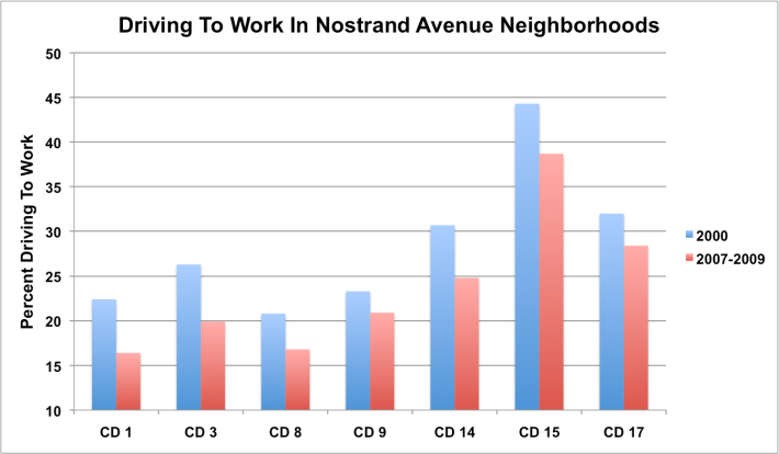
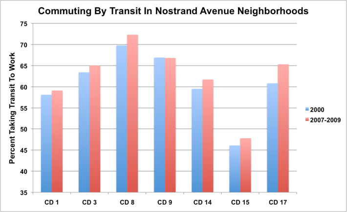
At debates like those, marshaling facts about the district that the community board is supposed to represent can be valuable. Of all the community boards along Nostrand, CB 15 represents the fewest transit riders, the Brooklyn College data shows. But even there, more commuters take transit than drive, and the gap is growing. Between 2007 and 2009, 47.8 percent of CB 15 residents rode transit to work; during the same period, only 38.7 percent drove. In 2000, 46.1 percent took transit while 44.3 percent took their car.
The story is the same up and down Nostrand Avenue. In every community district, driving is down (below 17 percent of commuters in both Greenpoint/Williamsburg and Crown Heights). In all but one, transit is on the rise, and in every district, more commuters use transit than any other mode.
When the Nostrand SBS launches this summer, there's sure to be a fresh round of griping about lost parking spaces and less space for private car travel. When that happens, this Census data should serve as a valuable reality check.


