Skip to Content
Streetsblog New York City home
Log In
Bicycling

20-20 Vision Zero: Mayor Adams Wants to Create a Harlem River Greenway

The Harlem River looking north from the High Bridge. Just imagine a greenway here one day. Photo: Kevin Duggan

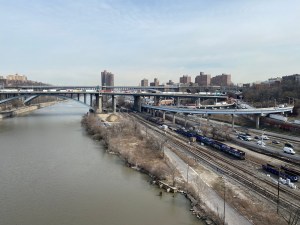
Mayor Adams wants to build a seven-mile greenway along the Harlem River in the Bronx, turning the borough's wasteland western waterfront into a safe route for Boogie Down bicyclists and pedestrians from Van Cortlandt Park to Randalls Island.

City officials will start planning the route in the coming year with virtual community meetings beginning next month, but the project will be challenging as some of the land along the proposed path is owned by private developers and the state.

The mayor also vowed to open up more bike and pedestrian space on the Harlem River's car-dominated bridges connecting the Bronx to northern Manhattan, reviving five-year-old efforts under his predecessor Bill de Blasio to improve the crossings.

"When we talk about greenways and our waterfront, we often do not include the Bronx and Washington Heights in this initiative, but that ends," Adams said at a news conference on the High Bridge, one of the few bike and pedestrian connectors between the Bronx and Upper Manhattan.

The city will host three evening online workshops starting on April 18 to hear from Bronxites about their ideas for the greenway's design, and Adams said the city will finalize a plan next year. City Hall does not have a timeline for when the new transportation infrastructure in the Bronx will open or how much it will cost, according to a spokesman.

Officials have also not yet set an exact route, but DOT put out a map Wednesday that shows the path going largely along the waterfront and the Major Deegan Expressway. It more or less parallels an ongoing $227-million project for a greenway on the Manhattan side between East Harlem and Inwood.

The city released this rough route for the proposed Harlem River Greenway in the Bronx. Map: DOT

The Bronx greenway will run along the waterway "whenever possible," said Department of Transportation Commissioner Ydanis Rodriguez, but might also divert inland, since the city will have to negotiate with developers and state agencies to get the space.

There are a few existing slices of greenway or waterfront paths already, such as Bridge Park, Robert Clemente State Park, and Mill Pond Park, but to get all the other properties on board to fill in the gaps will take years if not decades, according to one longtime advocate.

"The entire greenway itself is going to take over a decade," said Chauncy Young, a Highbridge resident who coordinates the Harlem River Working Group, a local coalition of organizations working to develop the greenway and improve access to the channel.

Just as crucial is giving more space for cyclists and pedestrians on the many bridges that span the river, many of which only have narrow paths for people outside of cars.

"Getting communities to the greenway is gonna be just as important as having the greenway itself," said Young. "It’s all interconnected."

DOT released a report in 2018 showing how the city could improve bike and pedestrian access on the 11 bridges it controls over the waterway, by repurposing car lanes and other excess space, or widening spans. The plans also called for better bike infrastructure leading up to the bridges on both sides. 

Some bridges have narrow paths shared by walkers and bikes, while the pedestrian and bike High Bridge provides a scenic and safe connection, but the Parks Department closes it overnight.

Officials have announced plans to repurpose a car lane for a two-way bike lane on the Washington Bridge (not to be confused with the George Washington Bridge), slated to happen this year, while work to rehab the Broadway Bridge has been pushed back to 2027.

Adams said plans from the bridge blueprint were interrupted by the pandemic, but he vowed to pick them back up and improve the cross-borough connectors.

"The goal is to open up all these bridges. I ride across the bridges all the time on my bike, so I know how important it is," he said in response to a question by Streetsblog.

Mayor Adams on the High Bridge on Wednesday. Photo: Kevin Duggan

For the newly revealed greenway, starting at its northern end at Van Cortlandt Park, the paths could connect to the planned extension of the Putnam Rail Trail, which is slated for railroad right-of-way extending south of the massive green space which the city recently bought from CSX Transportation.

Metro-North owns sections of the rail property south of 230th Street, so the city would have to get permission from the Metropolitan Transportation Authority, which operates the commuter line, to continue through and onward to the river.

Developer Dynamic Star plans to build a $2 billion mega-project of apartments and offices along a strip of land to the south with a promenade "to connect greenways," Norwood News reported.

There are some patches of waterfront access going south to the High Bridge, before stopping again at Metro-North's Highbridge Yard.

The Highbridge Yard seen from the High Bridge. Photo: Kevin Duggan

Real estate developers near the 145th Street bridge are supposed to build waterfront access as part of a local rezoning.

The city could continue for parts on Exterior Street on the inland side of some private properties, but the roadway adjacent to the Major Deegan is a "crazy street that's like a no man's land," Young said.

The route's southern end should be at the Randall's Island Connector, Young said, but there are also some industrial properties beforehand like the Harlem River Yard Transfer Station.

While those changes will still be years in the future, they will bring much-needed open space to the borough, said Young, whose group has been fighting for a greenway for three decades.

"Once we have greenways, families are going to be able to exercise, get out, spend time, enjoy time in parks. The rest of New York City has it and the Bronx deserves it too," he said.

Stay in touch

Sign up for our free newsletter

More from Streetsblog New York City

Friday’s Headlines: Canal Street Follies Edition

Manhattan Borough President Mark Levine isn't happy. Plus other news.

April 26, 2024

Community Board Wants Protected Bike Lane on Empire Blvd.

Brooklyn Community Board 9 wants city to upgrade Empire Boulevard's frequently blocked bike lane, which serves as a gateway to Prospect Park.

April 26, 2024

The Brake: Why We Can’t End Violence on Transit With More Police

Are more cops the answer to violence against transit workers, or is it only driving societal tensions that make attacks more frequent?

April 26, 2024
See all posts